Students can Download 2nd PUC Geography Previous Year Question Paper March 2017, Karnataka 2nd PUC Geography Model Question Papers with Answers helps you to revise the complete Karnataka State Board Syllabus and score more marks in your examinations.
Karnataka 2nd PUC Geography Previous Year Question Paper March 2017
Time: 3 Hrs 15 Min
Max. Marks: 100
I. Answer the following questions in one sentence each: (10 × 1 = 10)
Question 1.
Who is the founder of population Geography?
Answer:
G.T. Trewartha.
Quetion 2.
What is an Industry?
Answer:
Conversion of raw materials into finished goods and semi finished goods.
Question 3.
Which is the longest railway line of the world?
Answer:
Trans – Siberian Railway
Question 4.
What is the major occupation of the people of rural settlement?
Answer:
Agriculture, animal husbandry.
Question 5.
Which state has highest density of population in India?
Answer:
Bihar.
![]()
Question 6.
Which is the Longest dam of India?
Answer:
Hirakud.
Question 7.
Which is the highest sugarcane producing state in India?
Answer:
Uttar Pradesh.
Question 8.
Which is called ‘Black Diamond’?
Answer:
Coal.
Question 9.
Expand VISL.
Answer:
Vishveswariah Iron and Steel company Limited.
Question 10.
Name the major port of Kerala.
Answer:
Kochin.
II. Answer any 10 of the following questions in 2 to 3 sentences each: (10 × 2 = 20)
Question 11.
What are the types of mining?
Answer:
The different technique of mining are
- Open cast mining
- Underground mining
- Shaft mining
Question 12.
Mention the tertiary economic occupations.
Answer:
It includes all kinds of services, retail, entertainment, banking, education, healthcare, transportation & communication
Question 13.
Mention any four problems of urban settlements.
Answer:
Large scale urbanizations results with many problems.
1. Economic problems – Increasing population in the urban centres causes unemployment.
2. Socio-cultural problems
- Increasing the population results in lacking of social sendees as they cannot reach to everyone.
- Insufficient financial resources fail to create adequate social infrastructure and scarcity ‘ to the basic needs of huge population.
3. Environment problems – Urbanization also causes deterioration of environment quality by pollutions and disposal of waste.,
4. Problems of slums
- Slums are the most important and severe problem of urban settlements.
- Poverty, housing, sanitation, water facilities are the problems.
- Now-a-days the slums are occupying a large space of the urban centres and are still expanding.
Ex: Dharavi of Central Mumbai is the fastest grown and the largest slum of Asia.
Question 14.
What is the difference between emigration and immigration?
Answer:
Immigration: is used for in-migration from across the international border where.
Emigration: is used for out-migration from one country to another.
Question 15.
Why black soil is quiet suitable for cotton cultivation?
Answer:
- It keeps the Moisture for the long time.
- This soil is capable of retaining moisture to the crops. Therefore it is quiet suitable for cotton cultivation.
Question 16.
Name the types of iron ore.
Answer:
- Magnetite
- Haematite
- Limonite
- siderite
![]()
Question 17.
Write any four uses of manganese ore.
Answer:
Uses :
- Manganese is used to make steel tough and resistant to rusting.
- It is also used in the manufacture of paints, varnishes, batteries, dyes, fertilizers, pottery, calico printing, medicine.
- Manufacture of black enamel in chemical industries, bleaching powder, electrical, glass industries etc.
Thus it is known as “Jack of all Traders”.
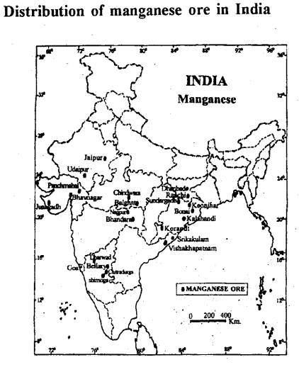
India has occupied the second place in respect of Manganese ore reserve in the world after Zimbabwe.
- Odisha : Odisha has about 40.4 percent of India’s reserves of Manganese ore. It is the largest producer and contributes over 24.1 percent of the manganese ore in htdia.
Best varieties of Manganese ore is found in Sundargarh, Kalahandi and Korput districts. - Maharashtra : It contributes about 27.7 percent of India’s manganese ore. The main manganese belt is in Nagapur and Bhandara districts.
- Madhya Pradesh : This state contributes nearly 27.6 percent of the total production of Manganese in the country.
Manganese ore are extend in Balaghat, Chindwara, Jabalpur and Dewas districts. - Karnataka : About 5.8 percent India’s Manganese ore is produced by Karnataka. The main Manganese ore deposits occur in Uttar Kannada, Shimoga, Bellary, Chitradurga and Tumkur districts.
- Andhra Pradesh : It contributes 13.8 percent of the total maganese ore production of the country. It is found in Srikakulam, Vishakapatnam, Nellore, Kumool and Cudapha dis-tricts.
- Others : Rajasthan, Gujarat, Jharkhand, West Bengal, Bihar etc are the states in which Manganese ore are distributed.
Production :
- India is the 5th largest producer of manganese ore in the world.
- Its total production was 23.22 lakh tonnes in 2010-11.
- The production of manganese is increasing from one year to another.
Question 18.
What are the four major raw materials used in Cement industry?
Answer:
Limestone, sea shalls, slag, silica alumina, clay and gypsum are the raw material used in the cement industry
Question 19.
Mention the materials of imports of india.
Answer:
Imports of India : Imports trade of India refers to buying goods from foreign countries and bringing them to home country.
The main items of Imports of India are :
1. Petroleum crude and products :
- It is the most important materials of Indian.Imports.
- In 2006-2007 India imported rupees 2,58,572 crores worth of crude oil and other petroleum products.
- It contributed 23% of our total imports.
2. Pearls precious and semi precious stones :
India imported rupees 33,881 crores worth of precious stone.
3. Capital goods :
In 2006-2007 India imported rupees 2,51,136 crores worth of capital goods.
4. Fertilizers :
India is a major importer of chemical Fertilizers. It is because the country is agrarian and the Internal production of fertilizers is insufficient. Potash fertilizers are largely imported.
Exports of India : Export trade of India refers to the sale of goods and services by India to other countries of the world.
The main items of our exports are as follows :
- Agricultural and Allied products: Products such as cereals, pulses tobacco, spices, nuts and seeds, oil meals, caster oil etc.
During 2011-2012 exports income is about US dollar 13300.63 million. - Ores and minerals: Export of ores and minerals like Iron ore, Manganese, Micca was estimated at US dollar 4700.29 million during 2011-12.
- Gems and Jewellery: India imports gems and precious stones in their raw form and . exports them after proper cutting and polishing.
- Electronic goods: Items under this group of consists of machinery, iron, steel and other engineering items.
- Petroleum products: Export of petroleum products increased to US dollar 34667.02 million.
![]()
Question 20.
Which materials are transported through pipelines?
Answer:
- It is most convenient, efficient and cheap mode of transporting products like crude oil and refined products, gas, water and milk.
- At present solid materials are also transported through pipeline after converting them into slurry.
Advantages of Pipelines :
- Pipelines can be laid through difficult terrain and also through water.
- The initial cost of laying the pipelines is high but the subsequent cost of maintainence and operation is low.
- Pipelines ensure a steady supply and minimizes trans-shipment losses and delays.
- Pipelines operation involves very low consumption of energy and keeps the environment free from pollution.
- Pipeline regions unites industrial regions.
Disadvantages:
- The capacity of pipelines cannot be increased once they are laid.
- The security of pipelines in certain areas and the detection of leakage are difficult.
- The construction of pipelines are expensive.
Question 21.
How is water pollution caused?
Answer:
- Sewage disposal
- Urban runoff
- Toxic effluents from industries
- Run-off over cultivate lands and nuclear power plants.
Question 22.
Mention two sources of solid waste.
Answer:
- Household or Domestic establishment
- Industrial or Commercial establishment
III. Answer any eight of the following questions in 25 to 30 sentences each: (5 × 8 = 40)
Question 23.
Explain the significance of the study Of human Geography.
Answer:
Scope of human Geography:
As early societies became more successful in meeting their need within.permanent settlements.
- The rise of agriculturing activities resource extra and manufacturing activities led to more complex economic and political boundaries were created and more settlement grew into towns and cities.
- The physical environment also changed with the influence of modem urbanize and industrialized world that we known today.
- One of the greatest challenges faced by humans today is how to manage energy resource in a sustainable fashion without inflicting permanent damage to environment in the form of land, air, water, pollution and climatic changes.
Importance of Human Geography:
- It clarifies the societies and cultures in different ^locations.
- The great diversity reflects through the fashion life.
- Which realizes carrying capacity of the Earth.
- It helps us to understand circumstances affecting people and nation.
- It is helpful to the planners, administrations, Industrialists and others.
Question 24.
Explain the stages of demographic cycle.
Answer:
Demographic cycle is the process of population transformation from the countries of high birth rate and high death rates to low birth rate & low death rate countries.
Stages of Demographic cycle:
1. First stage: High birth rate and high death is found when the country is economically most backward, so the population remains stationary. India was in the stage till 1920.
2. Second stage (Early expanding): It begins with the declining of death rate while the birth rate remains unchanged. These changes due to the advancement of science & technology, basic healthcare and education etc. At present many developing countries of Asia & Africa are in this stage.
3. Third stage (Late expanding): Death rate declines and birth rate begins to fall due to access of contraceptives, urbanization, an increase in the status and women education etc India appears to be this stage.
4. Fourth stage (Low stationary): It is characterized with low birth rate and low death rate. Growth is stationary due to changing life style, high obesity and many diseases are caused in this stage. Japan, Sweden, Belgium Denmark & Switzerland are in this stage.
5. Fifth stage(DecIining): Population begins to decline or birth rate is lower than deathrate. East European countries like Germany and Hungary and North European countries like Sweden, Norway are now in this stage.
Question 25.
Discuss about the measurement of human development.
Answer:
Meaning of Human development:
Human development is “development that enlarges people’s choice and improves their lives”. Standard of living & where people can live meaningful lives. Such as healthy, able to develop their talent, Participate in the activities of society etc.
Measurements of Human Development:
Human development is measured with –
1. The Human development Index.
2. The Human poverty Index.
1. The Human development index: It is measured in three dimensions.
- Health: Good health results of higher life expectancy means the people have a greater chance of living longer and health.
- Education: Based on the literacy rate development and status of a persons decides.
- Decent standard of living: It is measured in terms of purchasing power (in US dollars).
2. The Human poverty index: It measures the short fall in human development in following indices.
- The probability of not surviving till the age of 40.
- The adult illiteracy rate.
- The number of people who are not able drink pure water.
- The number of small children who are under weight.
![]()
Question 26.
Give an account of ocean (sea) water ways of the world.
Answer:
Water Transportation is ideal for the movements of bulky heavy large quantities of commodities as well as perishable products. As such the oceans are considered as the natural high ways of the world. Some of the important ocean routes are:
1. The Northern Atlantic Sea Route: It connects North Eastern USA & North Western Europe, the two industrially developed regions of the World. The North Atlantic Sea Route is the busiest Route in the world and called “The Big Trunk Route”.
2. The Mediterreanean Sea Route: This Route passes through the heart of the old world and serves more countries.
3. The Cape of Good Hope Sea Route: The Cape of Good Hope Sea Route is the oldest route of the World, Discovered by Vasco-Da-Gama in 1948. Many Ships follow this route to avoid Heavy Taxation at the Suez canal.
4. The North-Pacific Sea Route: The North-Pacific sea route connects the ports are Vnconver, Seattle, Postland, Sanfrancisco, Losangles on American side and Yakohoma, Kobe, Shangai, Hanking, Manila, Singapore on the Asia side.
5. The South Atlantic Sea Route: The Eastern Coast of South America with Western Coast of South America with Western Coast of Africa and Europe. This route is not well developed.
6. Shipping Canals: The shipping canals are most important and plays a crucial role in the World transport pattern. The Major shipping canals in the world are – The Suez and the Panama Canals.
Question 27.
Explain the reasons of rapid growth of population in india.
Answer:
1. High Birth Rate – High birth rate is the dominate factor in rapid growth of population in India. It was 49.2 in 1901 and has declined to 22.22 per thousand in 2011.
- Causes for high birth rate : There are several causes for high birth rate in India. For example: Early marriage, Universal marriage, religious and superstitions, joint family system, illiteracy, polygamy, predominance of agriculture, poverty, slow urbanization process, tropical climate etc. All these factors have been caused directly or indirectly for high birth rate.
2. Low Birth rate : Death rate was very high (42.6) in 1901, but it was sharply declined to 6.4 per thousand persons) in 2011.
- Causes for low death rate: There are many causes for declining trend of deathrate they are control of epidemics, decline in the incidence of Malaria and tuberculosis expansion of medical facilities, control of infant mortality, spread of education, improvement in the nutrition level etc, due to all of these programs and activities, death fate has been declining from one decade to another.
Question 28.
Discuss the factors influencing on distribution of population in india.
Answer:
The important factors are
1. Physical features – The Mountain and hilly regions are emost unstable for human habitation. For example; Northern Mountain, Western and Eastern Ghats, North Eastern hilly regions are moderately populated. The fertile great plains of North India and the river deltas have high density of population.
2. Climate – The density of population is high in good climatic regions. But the-very hot or cold and very dry climatic regions have low density of population.
3. Soils – The fertile soil regions have high crop productivity. So, the Northern, Eastern and Western coastal plains are most densely populated. In contrast, infertile sandy areas are less productive and they are low populated.
4. Resources – Mineral and power resources promote rapid economic development. Therefore, such areas are densly populated. For example, Chhattisgarh, Odisha, West Bengal etc.
5. Industries, Trade and Commerce – Highly industrialized, Commercial and business areas of the country have densly populated. For example Mumbai, Surat, Bhilai, Duigapur, Bangalore etc.
6. Security – People like to stay in a good security of life and property. Hence it is also influenced on population distribution. For example, Border areas of Jammu and Kashmir and Rajasthan are sparsely populated.
Question 29.
What is irrigation? Explain the need for irrigation in india.
Answer:
It is an artificial means of watering the crops or an art of supplying water to the crops.
Need for Irrigation : Distribution of water resources are highly varied. While some areas are dry some are wet and humid in such circumstances, we have to arrange water for crops through artificial means for fulfilling their needs. Thus, irrigation becomes necessary on account of following reasons.
- Nature of rainfall Due to irregular, uncertain and limited rainfall scarcity of water is caused so, need for irrigation arises.
- Nature of soil There is greater need of irrigation in sandy soil.
- Probability of DroughtAt places of droughts irrigation is essential.
- Need of Irrigation in dry areas In dry areas, where rainfall is less than 40 to 50 cm per year, the need arises for irrigation.
- More need of w;ater for special crops like rice, jute, sugar cane etc.
- More need of water to improve new and high yielding varieties of seeds for higher productivity.
- Water is essential to develop pastures for cattle and dairy development.
- Population of India is Multiplying fast, and it needs additional food production. This can be possible only through irrigation.
![]()
Question 30.
Give an account of upper Krishna Project.
Answer:
This is the biggest Multipurpose project in North Karnataka across the river Krishna.
- It comprises two dams namely Alamatti and Narayanapura.
- The Alamatti dam is constructed near Alamatti village in Basavana Bagewadi taluk and the Narayanapura dam is located near Siddapur village in Muddebihal taluk of Bijapur district.
- The Alamatti dam is 1,578 mt long & its height is 47.8 mt above the lowest foundation level with a gross capacity of 5,285 mcum.
- The Narayanapura dam is 10,637 mt long and 29.7 mt high above the lowest foundation level with a gross capacity of 10,66 mcum.
- It is going to irrigate about 6.22 lakh hectares of land in Bagalkot district, Bijapur district, Yadgir district, Gulbarga district, Raichur district.
- The project also include 6 units of power generation at Alamatti having a total capacity of 268 mw.
Question 31.
Explain the factors influencing on the location of industry.
Answer:
Some important factors are:
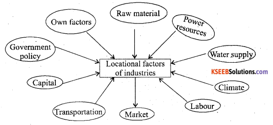
- Raw materials Industries are set up close to or in the regions where raw materials is available.
- Power Resources Power is essential for running the machinery of industries and influences much on the industrial location.
- Water supply Large quantities of water essential for the processing of raw materials or for cooling purposes. Therefore industries are usually localized near rivers or lakes.
- Climate: Industries are influenced by climate. For example Cotton textile industry requires humid climate.
- Labour Cheap and efficient labour is required to work in the industries.
- MarketNearness to market is essential for quick marketing of manufactured goods.
- Transportation It is necessary to carry raw materials to the factories and to carry finished products to the markets as well.
- Capital Development of Industries requires large capital investment.
- Government must have favourable policies such as tax exemptions electricity and sites at concessional rates, subsidies, rail-link, improved roads etc.
Question 32.
Explain the distribution of cotton textile industries in india.
Answer:
Importance:
- It provides employment to over 35 million people in the mills, power looms and hand loom sector.
- Indirectly millions of people derives livelihood in cotton production, processing trade, garments and also in the textile machinery sectors.
- It is the most important sector of employment in the country next to agriculture.
- The export of cotton textiles contributes about 17 percent Our total export earnings etc.
Distribution of cotton textile industries:
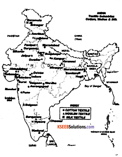
- Maharashtra: It is the largest producer of cotton textile in the country. It produces 39.38 percent mill cloth and 1079 percent yam of India. It has 169 mills – these are located at Mumbai, Pune, Sangli, Nagpur, Sholapur etc It is called ‘Manchester of India’ and the cottonopolice of India.
- Gujarath: It is second largest producer of cotton in the country. It has 120 cotton mills which are located in Ahmadabad, Baroda, Rajkot, Bhuvanger, Surat etc.
- Tamilnadu: It has highest number of textile industries in the country . They are about 893 mills on the state they are found in Coimbatore, Madurai, Salem, Tirpur etc. Coimbatore is the most important center with 323 cotton mills. It is called the ‘Manchester of South India’.
- Karnataka: There are about 54 industries which are located at Davanagere, Hubli, Bellary, Gokak, Mysore, Bengaluru etc Davanagere is the chief center cotton textile in Karnataka.
- Uttar Pradesh: Kanpur is the chief center of cotton mills in Uttar pradesh. Other important centers are Agra, Bareily, Aligarh, Moradabad, Varanasi etc.
- Madhya Pradesh: There are 52 cotton textile industries in the state. They are located at Indore, Gwalior, Ujjain, Bhopal and Jabalpur.
- West Bengal: The industries are elargely found in Kolkata Howrah.
- Others : In Rajasthan, Haryana, Punjab, Andhra Pradesh etc.
Question 33.
Explain the importance of road transport of India.
Answer:
A well known and co-ordinated system of transport plays an important role on trade, transport, social integration and economic development of the country. Importance:-
- Roads play a vital role in transporting the passengers for a short and medium distances.
- It is capable of providing door to door service
- the perishable goods like vegetables, fruits, and milk can be transported easily by road ways.
- Road – transport helps the industry by moving raw materials to industries and finished goods to market.
- it provides employment opportunities.
- The road traffic accounts for 85% of passengers and 65% of goods traffic by the end of length plan.
- It plays a vital role in national and International security.
- In hilly area, roads are only the means of effective transport.
- Lastly roads are especially useful for defence, purpose, particularly in border areas.
![]()
Question 34.
Explain the causes and effects of deforestation.
Answer:
- Extension of agriculture
- Constraction of roads, railways and industries
- Establishment human settlements and
- Mining activities
Effects of deforestration:
- Soil degradation and soil erosion.
- Destruction of natural habits of wild life and loss of biodiversity.
- Climatic changes such as desertification, global warming and etc.
Remedies to control the deforestration:
- Prevention of human settlements in forest areas.
- Check on expansion of agriculture.
- Prohibition of setting up of industries in forest areas.
- Controlling on irresponsible cutting down timber trees.
- Control of over grazing on forest region.
- Controlling of mining activity in forest lands.
- Limitation on construction of Large dams in forest areas.
IV. Answer any one of the following questions : (1 × 10 = 10)
Question 35.
What are the Geographical conditions required for the cultivation of Rice? And explain its distribution in india. .
Answer:
Rice Cultivation is widely distributed in India. Its cultivation is concentrated in River valleys, deltas, flood plains, low lying coastal areas of North-Eastern & Southern India etc are important rice growing areas.
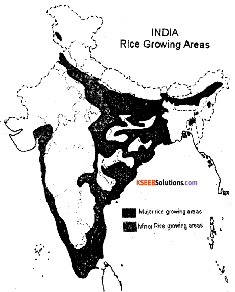
1. West Bengal : West Bengal is the largest producer of rice in India.
- About three fourth of the Total state’s cropped area is under the rice cultivation.
- Rice is growing in three seasons. They are called in different names.
- Aus
- Aman and
- Boro, Medinipur, Bardhaman 24 parganas, Bankura & Cochbehar are important rice producing districts in the state West Bengal producer 14.2% under total production of Rice in India.
2. Uttar Pradesh : This is second largest producer of rice in India.
- The rice cultivated area is concentrated in Gorakhpur, Basti, Varanasi, Allahabad, Shaharanpur, Azamgarh & Shajahanpur etc are important districts & major rice growing areas.
- Uttar Pradesh produces 13.44% of Rice under total production of Rice in India.
3. Andhra Pradesh : It is the third largest producer of rice in India.
- The delta of Godavari-Krishna & coastal plains are suitable for rice cultivation in the state.
- It contributes 12.3 5 % of Rice under total production of rice in India.
4. Punjab : Punjab is the fourth largest producer of rice in India.
- Amritsar, Patiala, Ropar, Firozepur districts are the major produces of rice in Punjab. Its share 10.11% under total production of Rice in India.
5. Bihar : Bihar is fifth leading producer of rice in India.
- Gaya, Rohtas, Bhajpur, Darbhanga, Champaran, Purenea, Bhagalpur & Patna districts.
It produces 6.90% under total output of rice in India.
6. TamilNadu: It is the sixth largest producer of rice in India.
- Tirunelveli, Tiruchirapalli, Salem, Madhurai, Coimbatore.
- Its production is 6.61 % under total production of total Rice in India.
7. Chattisgarh : It is the important producer of rice in country.
- Bastar, Bilaspur, Duig, Saiguja, Raipur, Raigarh& Janjgir are the main rice producing districts;
- Its production is 5.78% under total production of Rice in India.
8. Karnataka : Karnataka has rapid progress in rice cultivation during last few years. The important rice producing districts are Raichur, Davangere, Mysore, Bellary, Shimoga, Mandhya & Koppal.
- Its production is 3.87% under total production of Rice.
- Production of rice : India is the second largest producer of rice in the world next to the China. It produceses 104.3 million tonnes of rice during 2011-12, it accounts for 22% of the worlds production. Now India is self sufficient in rice production.
![]()
Question 36.
Explain the importance, development and distribution of petroleum in India.
Answer:
Occurance :
- In India petroleum .was discovered in I860.
- Another important achievement was the discover of oil in the Digboi area in 1889.
- The government of India contituted a separate Directorate of Oil and Natural Gas Commission (ONGC) on August 1956, Oil India Ltd., (OIL) on February 1959.
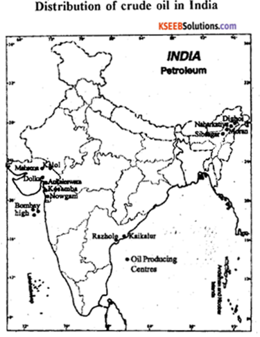
1. Bombay High: This is the largest oil producing area contributing 42.7 percent of the total crude oil output of the country.
- It is found in coat of Maharashtra about 176 km of the North-West Mumbai.
- It is known as “Sagar Samrat”.
2. Assam :
- In India the petroleum was first dicovered at Makum (Assam) in 1867. The first oil well was drilled at Digboi.
- It contributes about 13.2% of the oil production in the country. ‘
- Major oil fields of Assam state are the Digboi, Naharkatiya, Rudrasagar, Sibsagar and Hugrini.
3. Gujarat: It contributes 15.2% of Petroleum production in India.
Ankaleshwar and Cambay are the main oil fields, Kolob, Nangaon etc.
4. The Eastern Coast Oil field : The basin and deltas of the Godavari, the Krishna of Andhra Pradesh and the Cauvery river of Tamil Nadu holds great potential of oil and natural gas production.
5. Others : Uttar Pradesh, Punjab, Rajasthan etc Production :
- The total production of Petroleum in India was 380.9 lakh tonnes in 2011-12.
- India is not a significant producer of Petroleum in the world.
- Recently the domestic crude oil production has increased. This is because of the constant efforts made by ONGC and Oil India Ltd.
V. Answer the following questions: (2 × 10 = 20)
Question 37.
Construct a Pie-Diagram using data given in the table.
| Land-use pattern | Area (in million hectares) |
| 1. Forest | 69.63 |
| 2. Land not available for cultivation | 43.32 |
| 3. Cultivable waste food | 26.51 |
| 4. Fallow land | 24.80 |
| 5. Net area sown | 141.36 |
| 305.62 |
Answer:
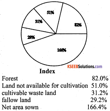
1. \(\frac { 69.63 }{ 305.62 }\) × 360 = 82%
2. \(\frac { 43.32 }{ 305.62 }\) × 360 = 51%
3. \(\frac { 26.51 }{ 305.62 }\) × 360 = 31.2%
4. \(\frac { 24.80 }{ 305.62 }\) × 360 = 29.2%
5. \(\frac { 141.36 }{ 305.62 }\) × 360 = 166.4%
Question 38
(a) Construct a simple line graph by using the following data.
Trend in Literacy rate of India
|
Year (in percentage) |
Lliteracy rate |
| 1951 | 18.33 |
| 1961 | 28.31 |
| 1971 | 34.45 |
| 1981 | 43.56 |
| 1991 | 52.21 |
| 2001 | 65.38 |
| 2011 | 74.4 |
Answer:
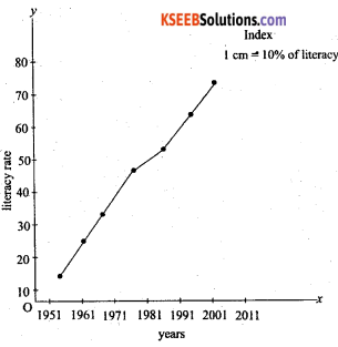
![]()
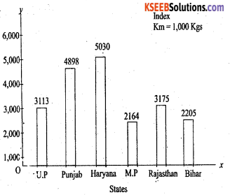
(b) Construct a single-bar graph by using the following data. India
Statewise yield of wheat 2011-12
| States |
Yield per hectare (in K.G’s) |
| Uttar pradesh | 3113 |
| Punjab | 4898 |
| Haryana | 5030 |
| Madhya | 2164 |
| Rajasthan | 3175 |
| Bihar | 2206 |
Answer:
For Blind Students only
Question 39.
Answer any two of the following : 2 x 10 = 20
(a) Explain the primary sources of data.
Answer:
Meaning – The data which are collected for the first time by a researcher or groups of researchers, institution or organizations are called Primary sources of data.
Types of Primary data collection:-
1. Through Personal interview : Personal interviews are the most commonly used method of collecting data, because the interviewer has the opportunity of explaing the study and answering any question, here the researcher gets direct information from the respondents.
2. By Personal observations: It refers to the collection of data or information by individual or group of individuals, through direct observations in the field.
3. By Questionnaire: The most common method used in surverys is the Questionnaire. In this method, simple questions and their possible answers are written on a plain paper, and the respondents have to tick mark the possible answers from given choices.
4. Others methods :
- Telephone interview : In this method, the researcher/interviewer can collect the information over the telephone.
- Measuring properties : In this method, the data about properties of soil, and water collected directly from the field by measuring their characteristics using soil and water quality kit.
(b) Explain the segment of GPS
Answer:
There are three segments of GPS:-
1. The space segments : The satellites of GPS are launched and positioned at an altitude of approximately 20200 km which is almost more than three times of the earth’s radius. The space segment consists of a constellation of 24 functioning GPs satellites located in 6 orbital plane with 4 satellites in each orbital plane. The time for the satellite to complete
one revolution around the earth is 11 hrs and 58 minutes.
2. The control segment: The control segment consists of facilities necessary for satellites especially healthy monitoring, telemetry, tracking command and control clock error ‘ computation .of satellites. There are 5 GPS stations spread over the earths surface they arc –
- Hawaii
- Colorado spring
- Ascension Island
- Diego Garcia
- Kwajalein.
3. The user segment: It is a total user and supplier community, both civilian and military. The user segment consists of all earth – based GPS receivers. Receivers very greatly in size and complexity, through the basic design in rather simple. The space and control segments are largely transparent to the operations of navigation functions.
![]()
(c)
Explain the elements of remote sensing.
Answer:
1. Energy source of Illumination (A) – The first requirement for remote sensing is to have an energy source which illuminates or provides electromagnetic energy to acquire information of the earth’s surface.
2. Radiation and the Atmosphere (B) – As the energy travels from its source to the target, it will come in contact with and interact with the atmosphere it passes through.
3.,Interaction with the Target (C) – Once the energy makes its way to the target through the atmosphere.
4. Recording of energy by the sensor (D) – After the energy has been scattered by or emitted from the target we require a sensor to collect and record the electromangnetic radation.
5. Transmission, Reception and Processing (E) – The energy recorded by the sensor has to be transmitted, often in electronic form, to a receiving and processing station where the data are processed into an image.
6. Interpretation and Analysis (F) – The processed image is interpreted, visually/or digitally or electronically, to extract information about the target which was illuminated.
7. Application (G) – The final elements of the remote sensing process is acheived when we apply the information to better understand it and solve a particular problem.