Students can download Class 10 Geography Chapter 6 Indian Water Resources Important Questions, KSEEB SSLC Class 10 Social Science Important Questions and Answers helps you to revise the complete Karnataka State Board Syllabus and score more marks in your examinations.
Karnataka SSLC Class 10 Social Science Geography Important Questions Chapter 6 Indian Water Resources
Question 1.
What are the uses of water?
Answer:
Water is one of the most precious natural resources. It is impossible to sustain life without water. Water is used by human beings for drinking, cooking, washing, agriculture, generating hydro – electricity, industries, navigation, etc.
Question 2.
Which are the different resources of water?
Answer:
Water resources can be divided into surface water and ground water resources. The surface water resources are rainfall, rivers, lakes, tanks and springs.
![]()
Question 3.
What are the uses of rivers?
Answer:
Rivers are useful for irrigation, generation of hydel power, inland waterways, fishing, etc.
Question 4.
Into how many groups are the river systems of India divided? Name them.
Answer:
The river systems of India can be divided into two groups. They are:
- Rivers of North India (Himalayan rivers)
- Rivers of Peninsular India (Peninsular rivers)
Question 5.
What are the rivers of North India also known as?
Answer:
The rivers of North India are also known as Himalayan rivers.
![]()
Question 6.
Which are the important river systems of North India?
Answer:
Indus, Ganges and Brahmaputra are the important river systems of North India.
Question 7.
Where does River Indus rise?
Answer:
River Indus rises near Mt. Kailash in Tibet.
Question 8.
Which sea does the Indus river join finally?
Answer:
The Indus river finally joins the Arabian Sea near Karachi in Pakistan.
![]()
Question 9.
Name the tributaries of river Indus.
Answer:
Jhelum, Chenab, Beas, Ravi and Sutlej are the tributaries of river Indus.
Question 10.
Write a note on Indus river system.
Answer:
River Indus or Sindhu rises near Mt. Kailash in Tibet. Initially it flows in the north – west direction and then in the south-west direction and enters Pakistan. Finally it joins the Arabian Sea near Karachi. The total length of Indus river is 2897 kms of which 709 kms lies in India. Jhelum, Chenab, Beas, Ravi and Sutlej are its tributaries.
Question 11.
Which is the longest river of India?
Answer:
River Ganga is the longest river of India.
Question 12.
Where does River Ganga rise?
Answer:
River Ganga rises in the Gangotri glacier.
Question 13.
Which river does River Ganga join after entering Bangladesh?
Answer:
River Ganga joins River Brahmaputra after entering Bangladesh.
![]()
Question 14.
Name the tributaries of River Canga.
Answer:
The tributaries of River Ganga are Yamuna, Ghaghra, Gandak, Ramaganga, Gomati, Sarada, Son and Kosi.
Question 15.
Which is the longest tributary of River Canga?
Answer:
Yamuna is the longest tributary of River Ganga.
Question 16.
Write a note on Canga river system.
Answer:
The Ganga is the longest river of India. It rises in the Gangotri glacier. It flows towards the south and then south-east and then enters Bangladesh where it joins the Brahmaputra. After joining the Brahmaputra, it continues as river Padma and finally flows into the Bay of Bengal. The total length of Ganges river is 2525 kms. Its major tributaries are Yamuna, Ghaghra, Gandak, Ramaganga, Gomati, Sarada, Son and Kosi.
Question 17.
Where does River Brahmaputra rise?
Answer:
River Brahmaputra rises near Lake Manasa Sarovar in Tibet.
![]()
Question 18.
Explain the Brahmaputra river system.
Answer:
The Brahmaputra rises near Lake Manasa Sarovar in Tibet and flows towards the east. It enters India through a narrow gorge in Arunachal Pradesh. Then it flows to the west and turns to the south in Bangladesh where it joins the Ganga. Its total length is 2589 kms.
Question 19.
By what other names is River Brahmaputra known?
Answer:
River Brahmaputra is known as Tsang-Po in Tibet and Jamuna in Bangladesh.
Question 20.
Which is the world’s largest river island formed by River Brahmaputra?
Answer:
Majuli is the world’s largest river island formed by River Brahmaputra.
Question 21.
What are the South Indian rivers known as?
Answer:
The South Indian rivers are known as Peninsular rivers.
Question 22.
Where do most of the South Indian rivers rise?
Answer:
Most of the South Indian rivers rise in the Western Ghats.
![]()
Question 23.
Name the important rivers of South India.
Answer:
The important rivers of South India are Mahanadi, Godavari, Krishna, Kaveri, Narmada, Tapi and their tributaries.
Question 24.
Which are the east flowing rivers of South India?
Answer:
The east flowing rivers of South India are Mahanadi, Godavari, Krishna and Kaveri.
Question 25.
Write a note on River Mahanadi.
Answer:
River Mahanadi rises in Siwaha range, flows towards the east and joins the Bay of Bengal.
Question 26.
Which is the longest river in South India?
OR
Which is the longest river of the Peninsular Plateau?
Answer:
River Godavari is the longest river in South India.
Question 27.
Write a note on River Godavari.
Answer:
River Godavari is the longest river in South India. It rises in Triambaka, flows towards the east and joins the Bay of Bengal.
![]()
Question 28.
Name the tributaries of River Krishna.
Answer:
Bhima, Tungabhadra, Koyna, Ghataprabha and Malaprabha are the main tributaries of River Krishna.
Question 29.
Write a note on River Krishna.
Answer:
River Krishna rises near Mahabaleshwar, flows towards south-east and joins the Bay of Bengal. Its main tributaries are Bhima, Tungabhadra, Koyna, Ghataprabha and Malaprabha.
Question 30.
Which are the tributaries of River Kaveri?
Answer:
Hemavathi,Shimsha, Kapila,Arkavathi,Lakshmanathirtha,Suvarnavathi and Bhavani are the main tributaries of River Kaveri.
Question 31.
Write a note on River Kaveri.
Answer:
River Kaveri rises at Talakaveri in Kodagu, flows towards the east and joins the Bay of Bengal. Hemavathi, Shimsha, Kapila, Arkavathi, Lakshmanathirtha, Suvarnavathi and Bhavani are the main tributaries of Kaveri.
![]()
Question 32.
Which are the west flowing rivers of South India?
Answer:
Narmada,Tapi, Sabarmathi, Mandovi, Zuari, Bedti, Sharavathi, Kali, Netravathi and Periyar are the west flowing rivers of South India.
Question 33.
Write a note on River Narmada.
Answer:
River Narmada rises in Amarakantak Hills and flows westwards through a narrow gorge called Marble Gorge and joins the Arabian Sea.
Question 34.
Write a note on River Tapi.
Answer:
River Tapi rises near Multai, flows westward and joins the Arabian Sea.
Question 35.
Classify these rivers into Himalayan rivers and Peninsular rivers:
- Mahanadi
- Sutlej
- Kosi
- Gandaki
Answer:
- Himalayan rivers : Sutlej, Kosi, Gandaki.
- Peninsular river : Mahanadi.
Question 36.
What is irrigation?
Answer:
The artificial supply of water for the purpose of agriculture is called irrigation. It refers to the supply of water to agricultural land from rivers, reservoirs, tanks or from underground sources.
Question 37.
What is the need for irrigation in India?
OR
Explain the importance of irrigation in India.
OR
Irrigation is very essential in India. Why?
Answer:
India is an agricultural country. Therefore it needs a regular and sufficient supply of water. In India, agriculture depends mainly on the monsoon rains, which is seasonal, uncertain and unevenly distributed. Certain crops like rice, sugarcane, etc., require larger and regular supply of water. Besides, to increase the yield and production of crops, regular supply of water is required. This can be provided only through irrigation. Hence the importance of irrigation in India.
![]()
Question 38.
Mention the types of irrigation practiced in India.
Answer:
Well irrigation, canal irrigation and tank irrigation are the different types of irrigation practiced in India. Recently other types of irrigation such as sprinkler irrigation and drip irrigation have been introduced.
Question 39.
Which is the most important type of irrigation practiced in India?
Answer:
Well irrigation is the most important type of irrigation practiced in India.
Question 40.
What is well irrigation?
Answer:
Well irrigation is a system of supplying water to crops by digging or drilling wells.
Question 41.
What are the advantages of well irrigation?
OR
Explain the importance of well irrigation.
Answer:
- Well irrigation is possible even in areas of low rainfall
- It is cheap and easy to dig wells
- It does not require superior technology
- Even small farmers can dig wells easily.
Question 42.
List the states where well irrigation is practiced in India.
OR
Explain the distribution of well irrigation in India.
Answer:
Well irrigation is largely practiced in the Ganga Plains including Punjab, Haryana, Uttar Pradesh, Bihar and West Bengal. In South India, well irrigation is practiced in Tamil Nadu, Andhra Pradesh and Karnataka.
![]()
Question 43.
Which are the two types of wells?
Answer:
Open wells and tube wells are the two types of wells.
Question 44.
Write a short note on well irrigation in India.
Answer:
Well irrigation is the most important type of irrigation in India. Nearly 60.7% of the total irrigated area comes under well irrigation. It is largely practiced in the Ganga Plains including Punjab, Haryana, Uttar Pradesh, Bihar and West Bengal. In South India, well irrigation is practiced in Tamil Nadu, Andhra Pradesh and Karnataka. Well irrigation is of two types – open well irrigation and tube well irrigation.Tube well irrigation has become widespread in India.
Question 45.
Who is responsible for the construction and maintenance of canals in India?
Answer:
The government is responsible for the construction and maintenance of canals in India.
Question 46.
Which are the two types of canals?
Answer:
Inundation canals and perennial canals are the two types of canals.
Question 47.
Distinguish between inundation canals and perennial canals.
Answer:
In inundation canals, water is drawn directly from the river without constructing dams. In perennial canals, dams are constructed across rivers and water is stored in reservoirs. This water is used for agriculture through canals.
![]()
Question 48.
Name the states where canal irrigation is practiced.
OR
Explain the distribution of canal irrigation in India.
Answer:
Canal irrigation is practiced in Uttar Pradesh, Punjab, Bihar, Madhya Pradesh, Rajasthan, Haryana, Andhra Pradesh, Gujarat, Tamil Nadu, Odisha, West Bengal and Karnataka.
Question 49.
Write a note on canal irrigation in India.
Answer:
Canal irrigation occupies the second place after well irrigation. It accounts for about 27% of the total irrigated area in the country. India has one of the world’s largest canal systems. Canal irrigation is practiced extensively in Uttar Pradesh, Punjab, Bihar, Madhya Pradesh, Rajasthan, Haryana, Andhra Pradesh, Gujarat, Tamil Nadu, Odisha.West Bengal and Karnataka.
Question 50.
What is tank irrigation?
Answer:
Use of rainwater that has collected in natural or man – made reservoirs for the purpose of agriculture is called tank irrigation.
Question 51.
Name the states where tank irrigation is practiced.
OR
Explain the distribution of tank irrigation in India.
Answer:
Tamil Nadu, Andhra Pradesh, Maharashtra, Karnataka, Odisha, Madhya Pradesh, Rajasthan and Uttar Pradesh are the states where tank irrigation is practiced.
Question 52.
Write a note on tank irrigation in India.
Answer:
Under tank irrigation, rainwater that has collected in natural or man-made reservoirs is used for irrigation. In recent years the area under tank irrigation has decreased. Now only about 3% of the tot-‘ irrigated area is under tank irrigation. Tank irrigation is mainly practiced in Tamil Nadu, Andhra Pradesh, Maharashtra, Karnataka, Odisha, Madhya Pradesh, Rajasthan and Uttar Pradesh.
![]()
Question 53.
Which country has the largest area under irrigation in the world?
Answer:
India has the largest area under irrigation in the world.
Question 54.
What are multi – purpose river valley projects?
Answer:
The river valley projects which provide multiple benefits are called multipurpose river valley projects.
Question 55.
What are the main objectives of multipurpose river valley projects?
Answer:
The main objectives of multipurpose river valley projects are:
- To provide water for irrigation
- To control floods
- To generate hydroelectricity
- To prevent soil erosion
- To develop inland waterways and fishing
- To provide recreation facilities
- To provide water for domestic purposes and industries
- To reclaim land for agriculture Afforestation.
Question 56.
Name four multipurpose river valley projects of India.
Answer:
Damodar Valley Project, Bhakra-Nangal Project, Hirakud Project and Tungabhadra Project are four multipurpose river valley projects of India.
Question 57.
Which was the first multipurpose river valley project to be set up in India?
Answer:
The Damodar Valley Project was the first multipurpose river valley project to be set up in India.
![]()
Question 58.
Which river was called the ‘sorrow of Bengal’?
Answer:
River Damodar was called the ‘Sorrow of Bengal’.
Question 59.
Why was river Damodar called the ‘sorrow of Bengal’?
Answer:
River Damodar caused devastating floods in West Bengal during the rainy season and damaged crops and human settlements. Hence river Damodar was called the ‘sorrow of Bengal’.
Question 60.
What were the aims of the Damodar Valley Project?
OR
Why was the Damodar Valley Project taken up?
Answer:
The Damodar Valley Project was taken up with the following aims: To control the floods caused by river Damodar, to provide water for irrigation, navigation, generation of hydroelectricity, afforestation, control of soil erosion, promotion of mining, industries and inland fishing.
Question 61.
Name the places where dams have been constructed across river Damodar.
Answer:
Dams have been constructed across river Damodar at Tilaiya, Konar, Maithon and Panchet Hill.
Question 62.
Write a note on the Damodar Valley Project.
Answer:
The Damodar Valley Project is the first multipurpose river valley project of India. It has been designed on the lines of Tennessee Valley Authority in U.S.A The project has been jointly undertaken by the Governments of Bihar and West Bengal, across river Damodar and its tributaries. The project comprises four dams at Tilaiya, Konar, Maithon and Panchet Hill, a barrage at Durgapur and three thermal power stations at Bokaro, Durgapur and Chandrapur.
Question 63.
Which is the highest straight gravity dam in India?
Answer:
The Bhakra dam is the highest straight gravity dam in India.
![]()
Question 64.
Name the reservoir created by the Bhakra dam.
Answer:
The reservoir created by the Bhakra dam is called Gobind Sagar.
Question 65.
What are the objectives of the Bhakra – Nangal Project?
Answer:
The main objectives of the Bhakra – Nangal Project are flood control, irrigation facilities, generation of hydroelectricity, prevention of soil erosion and promotion of afforestation.
Question 66.
Write a short note on Bhakra – Nangal Project.
Answer:
The Bhakra – Nangal Project is the largest multipurpose river valley project in India. It is a joint venture of the states of Punjab, Haryana and Rajasthan. The project comprises two dams at Bhakra and Nangal across the river Sutlej in Himachal Pradesh and four power houses. The Bhakra dam is the highest straight gravity dam (226 metres high) in India. The reservoir created by the dam is called Gobind Sagar.
Question 67.
Which river was called the ‘sorrow of Odisha‘?
Answer:
River Mahanadi was called the ‘Sorrow of Odisha’.
Question 68.
Name the places where dams have been constructed across river Mahanadi.
Answer:
Dams have been constructed across the river Mahanadi at Hirakud.Tikrapara and Naraj.
![]()
Question 69.
Which is the longest dam in India?
Answer:
The Hirakud dam is the largest dam in India.
Question 70.
Write a note on the Hirakud Project.
Answer:
The Hirakud Project is the most important project of Odisha. The project comprises the construction of three dams on the river Mahanadi at Hirakud.Tikrapara and Naraj. It also has two hydel power stations. Hirakud is the longest dam in India.
Question 71.
Where is the dam across the river Tungabhadra constructed?
Answer:
The dam across the river Tungabhadra is constructed at Mallapuram near Hospet in Ballari district of Karnataka.
Question 72.
Name the reservoir created by the Tungabhadra Project.
Answer:
The reservoir created by the Tungabhadra Project is called Pampa Sagara.
Question 73.
Write a note on the Tungabhadra Project.
Answer:
The Tungabhadra Project is a joint venture of Karnataka and Andhra Pradesh. It comprises a dam and three hydel power stations. A dam has been built across the river Tungabhadra at Mallapuram near Hospet in Ballari district. The reservoir created by this dam is called Pampa Sagara.
![]()
Question 74.
Name the places where dams have been constructed across the river Krishna.
Answer:
Dams have been constructed across the river Krishna at Alamatti in Basavana-Bagewadi taluk and Narayanapura near Siddapura village in Muddebihal taluk of Vijayapura district.
Question 75.
Name the places that benefit from the Upper Krishna Project.
Answer:
Bagalkot, Vijayapura, Kalburgi, Yadgir and parts of Belagavi district benefit from the Upper Krishna Project.
Question 76.
Write a note on the Upper Krishna Project.
Answer:
The Upper Krishna Project is a multipurpose river valley project in North Karnataka across river Krishna. It comprises two dams – one at Alamatti in Basavana – Bagewadi taluk and the other at Narayanapura near Siddapura village in Muddebihal taluk of Vijayapura district, and a hydel power station. Bagalkot, Vijayapura, Kalburgi, Yadgir and parts of Belagavi district benefit from the Upper Krishna Project.
Question 77.
Which river was called the ‘sorrow of Bihar’?
Answer:
River Kosi was called the ‘Sorrow of Bihar’.
Question 78.
At which place is the dam across the Kosi river constructed?
Answer:
The dam across the river Kosi is constructed near Hanuman Nagar in Nepal.
Question 79.
Write a short note on the Kosi Project.
Answer:
The Kosi Project is an international project and a joint venture of India and Nepal. A dam is built across river Kosi near Hanuman Nagar in Nepal. The project has been executed by India but the benefits are shared by both India and Nepal.
![]()
Question 80.
Name the reservoir created by the Rihand Valley project.
Answer:
The reservoir created by the Rihand Valley Project is called Gobind Ballabh Pant Sagar.
Question 81.
Write a note on the Rihand Valley Project.
Answer:
The Rihand Valley Project is an important multipurpose river valley project of Uttar Pradesh. It is built across the river Rihand, a tributary of the river Son. The reservoir created by this dam is called Gobind Ballabh Pant Sagar.
Question 82.
Where is the Nagarjuna Sagar Project constructed?
Answer:
The Nagarjuna Sagar Project is constructed across river Krishna near Nagarjunakonda in Telangana.
Question 83.
What are the canals of the Nagarjuna Sagar Project called?
Answer:
The right bank canal of the Nagarjuna Sagar Project is called ‘Jawahar Canal’ and the left bank canal is called ‘Lai Bahadur Canal’.
Multiple – choice Questions
Question 1.
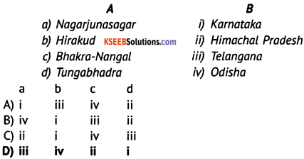
Match the projects under ‘A’ with the states given in ‘B’ and choose the correct answer from the combinations given below.

Answer:
D) iii iv ii i
Question 2.
The type of irrigation which is largely practised in India is ________
(A) Drip irrigation
(B) Tank irrigation
(C) Well irrigation
(D) Sprinkler irrigation
Answer:
(C) Well irrigation
Question 3.
Supplying water to agricultural lands through canals, wells and tanks is called ________
(A) farming
(B) cultivation
(C) irrigation
(D) water conservation.
Answer:
(C) irrigation
![]()
Question 4.
The largest irrigated area in the world is in ________
(A) India
(B) China
(C) Russia
(D) Australia
Answer:
(A) India
Question 5.
The multi – purpose river valley project jointly undertaken by Bihar and West Bengal is ________
(A) Damodar valley project
(B) Hirakud project
(C) Kosi project
(D) Bhakra – Nangal project
Answer:
(A) Damodar valley project
Question 6.
Damodar river is called ________
(A) Sorrow of Bengal
(B) Sorrow of Bihar
(C) Sorrow of Odisha
(D) Sorrow of Assam
Answer:
(A) Sorrow of Bengal
Question 7.
The river known as ‘Sorrow of Bihar’ is ________
(A) Damodar
(B) Mahanadi
(C) Ganga
(D) Kosi
Answer:
(D) Kosi
Question 8.
The highest straight gravity dam in India is ________
(A) Bhakra dam
(B) Nangal dam
(C) Hirakud dam
(D) Almatti dam
Answer:
(A) Bhakra dam
![]()
Question 9.
The dam built at Hanuman Nagar on the India-Nepal border is across the river ________
(A) Ganga
(B) Kosi
(C) Sutlej
(D) Gandak
Answer:
(B) Kosi
Question 10.
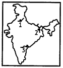
The exact matching of the marked river valley projects is ________

(A) 1 – Hirakud, 2 – Tungabhadra, 3 – Bhakra Nangal
(B) 1 – Tungabhadra, 2 – Bhakra Nangal, 3 – Hirakud
(C) 1 – Bhakra Nangal, 2 – Tungabhadra, 3 – Hirakud
(D) 1 – Bhakra Nangal, 2 – Hirakud, 3 – Tungabhadra
Answer:
(D) 1 – Bhakra Nangal, 2 – Hirakud, 3 – Tungabhadra
Question 11.
Which among the following is the longest dam in India?
(A) Hirakud
(B) Tungabhadra
(C) Nagarjunasagar
(D) Bhakra Nangal
Answer:
(A) Hirakud
Question 12.
This is a joint project between India and Nepal ________
(A) Narmada Valley Project
(B) Bhakra – Nangal Project
(C) Damodar Valley Project
(D) Kosi Project
Answer:
(D) Kosi Project
Question 13.
The multipurpose project constructed jointly by Karnataka and Andhra Pradesh is ________
(A) Tungabhadra Project
(B) Damodar Valley Project
(C) Nagarjunasagar Project
(D) Upper Krishna Project
Answer:
(A) Tungabhadra Project
Question 14.
River Indus rises near ________
(A) Mount K2
(B) Mount Abu
(C) Mount Kailash
(D) Mount Everest
Answer:
(C) Mount Kailash
Question 15.
The river which flows in three countries is ________
(A) Indus
(B) Ganges
(C) Yamuna
(D) Narmada
Answer:
(A) Indus
Question 16.
Kosi is the tributary of ________
(A) Ganges
(B) Indus
(C) Brahmaputra
(D) Krishna
Answer:
(A) Ganges
Question 17.
River Brahmaputra rises near Lake Manasa Sarovar in ________
(A) Assam
(B) Meghalaya
(C) Tibet
(D) Nepal
Answer:
Question 18.
The river Tsang – po is more popularly called ________
(A) Narmada
(B) Tapti
(C) Brahmaputra
(D) Yamuna
Answer:
(C) Brahmaputra
![]()
Question 19.
The river that rises at Triambak is ________
(A) Krishna
(B) Godavari
(C) Tapti
(D) Narmada
Answer:
(B) Godavari
Question 20.
The longest river in peninsular India is ________
(A) Cauvery
(B) Mahanadi
(C) Godavari
(D) Krishna
Answer:
(C) Godavari
Question 21.
River Krishna rises near ________
(A) Vindhyas
(B) Mahadeo
(C) Nasik
(D) Mahabaleshwar
Answer:
(D) Mahabaleshwar
Question 22.
River Cauvery rises at Talakaveri in ________
(A) Kodagu
(B) Mandya
(C) Chamarajanagar
(D) Mysore
Answer:
(A) Kodagu
Question 23.
River Narmada passes through a narrow gorge called ________
(A) Diamond Gorge
(B) Gold Gorge
(C) Marble Gorge
(D) Silver Gorge
Answer:
(C) Marble Gorge
Question 24.
River Tapi rises near ________
(A) Malabar
(B) Amarkantak
(C) Odisha
(D) Multai
Answer:
(D) Multai
![]()
Question 25.
Identify the river which flows towards the west.
(A) Mahanadi
(B) Krishna
(C) Narmada
(D) Godavari
Answer:
(C) Narmada
Question 26.
The west – flowing river of Karnataka is ________
(A) Netravathi
(B) Krishna
(C) Cauvery
(D) Tungabhadra
Answer:
(A) Netravathi
Question 27.
The exact matching of the marked River Valley projects is ________

(A) 1 – Hirakud, 2 – Tungabhadra, 3 – Bhakra Nangal
(B) 1 – Tungabhadra, 2 – Bhakra Nangal, 3 – Hirakud
(C) 1 – Bhakra Nangal, 2 – Tungabhadra, 3 – Hirakud
(D) 1 – Bhakra Nangal, 2 – Hirakud, 3 – Tungabhadra
Answer:
(D) 1 – Bhakra Nangal, 2 – Hirakud, 3 – Tungabhadra
Question 28.
The exact matching of the marked River Valley projects is ________

(A) 1 – Nagarjunasagar, 2 – Bhakra Nangal, 3 – Kosi
(B) 1 – Bhakra Nangal, 2 – Kosi, 3 – Nagarjunasagar
(C) 1 – Kosi, 2 – Nagarjunasagar, 3 – Bhakra Nangal
(D) 1 – Nagarjunasagar, 2 – Kosi, 3 – Bhakra Nangal
Answer:
(B) 1 – Bhakra Nangal, 2 – Kosi, 3 – Nagarjunasagar
Fill in the blanks
- River Indus rises near Mt.Kailash.
- The longest river in South India is Godavari.
- Hirakud Project is built across Mahanadi river.
- The longest tributary of the river Ganga is Yamuna
- The Kosi Project is a joint venture of India and Nepal.