You can Download Chapter 4 Transport and Communication Questions and Answers, Notes, 2nd PUC Geography Question Bank with Answers Karnataka State Board Solutions help you to revise complete Syllabus and score more marks in your examinations.
Karnataka 2nd PUC Geography Question Bank Chapter 4 Transport and Communication
2nd PUC Geography Transport and Communication One Mark Questions with Answers
I. Answer the following in a word or a sentence each:
Question 1.
What is Transportation?
Answer:
Transport is the means of carrying Goods & Passangers from one place to other by Human. Animals and different kinds of vehicles.
Question 2.
When was the First Railway Started?
Answer:
1825 between Stockton and Darlington in northern England.
Question 3.
Which continent has the highest density of rail network in the world?
Answer:
Europe is the highest density of Rail network in the world.
Question 4.
What is Ocean transport?
Answer:
Water transport is the means of carrying the goods and passangers through the boats, ships, steamers etc on the water from place to place.
Question 5.
What is Ocean transport?
Answer:
Carrying of heavy goods and Passangers through to the steamers and ships on the ocean from one country to another is called Ocean transport.
![]()
Question 6.
What are the inland waterways?
Answer:
The Movement of Goods, Passengers, through rivers canals, lakes is know as inland water¬ways.
Question 7.
What is Pipeline Transport?
Answer:
Pipeline is the means of carrying the liquid, slary and Gases through the pipes from one place to another.
Question 8.
What is Communication?
Answer:
Communication refers to Exchange of ideas and Information. From one person to another person.
Question 9.
What is Internet?
Answer:
An Inter connected system of networks that connects computers around the world.
![]()
Question 10.
What is cyberspace?
Answer:
The electronic medium of computer Networks, in which on line communication takes place.
Question 11.
Which is the Busiest canal in the world?
Answer:
The Suez canal is the Busiest canal in the world.
Question 12.
Expand ISRO?
Answer:
ISRO : INDIAN SPACE RESEARCH ORGANISATION. .
Question 13.
Which is the largest news agency in the world?
Answer:
The larget news Ageny in the world is Reuter. It is the first News Paper in the world.
Question 15.
What is Satellite Communication?
Answer:
An Artificial body in orbit around the Earth or another planet in order to collect and distribute information one place to another.
Question 16.
What is Road transportation?
Answer:
The means of carrying Goods and Passengers by road from one place to another place.
Question 17.
What is Rail transportation?
Answer:
The means of carrying heavy goods and large number of passengers for long distance through the Trains.
Question 18.
Who invented steam engine for the first time & when?
Answer:
Steam engine was invented by James Watt in 1781.
Question 19.
What is the total motorable road length of the word.
Answer:
15 Million kms.
Question 20.
When the Romans have constructed roads for the first time.
Answer:
In 400 BC.
Question 21.
When the Indians were built the road for the first time.
Answer:
During the period of Emperor Ashoka.
Question 22.
Which continent has the highest road density of the World.
Answer:
North America.
![]()
Question 23.
Name the pass which connects between canton to Ticino.
Answer:
The Gottard Pass located in Switzerland.
Question 24.
Name the highway of India which connects from Kanyakumari to Varanasi.
Answer:
NH – 7.
Question 25.
Name the longest road of the World.
Answer:
Pan American highway which connects Alaska – Canada – United States – Mexico.
Question 26.
Mention the total length of railways on the World.
Answer:
13,70,782 kms.
Question 27.
Which country has highest Length of railways for every l00sq km area.
Answer:
USA – 278.3/100 sq km area.
Question 28.
Name the railway proposal linking between Istanbul to Bangkok.
Answer:
Trans Asiatic railway.
Question 29.
Which is the busiest sea route in the World.
Answer:
North Atlantic sea route it is called “The Big trunk route”.
Question 30.
Which is the oldest sea route of the world.
Answer:
The Cape of Good Hope. ,.
Question 31.
Who discovered cape of Good hope & when.
Answer:
Vasco-Da-Gama in 1498.
![]()
Question 32.
Who was the first European reached the pacific for the construction of Panama canal.
Answer:
Vasounez-De-Balboa in 1517 A.D.
Question 33.
Who invented Aero plane for the first time.
Answer:
American wright brothers in 1903.
Question 34.
When was the first commercial aviation started in the world.
Answer:
1926 in USA.
Question 35.
Mention the places a flight reaches just 45 minutes.
Answer:
From Mumbai to Newyork.
Question 36.
Name the country which supplies milk through the pipelines from forms to Factories.
Answer:
NewZealand.
Question 37.
Who invented Telegraph.
Answer:
Samuel morse in 1844.
Question 38.
Who invented Telephone.
Answer:
Alexender Graham bell in 1875.
Question 39.
Who invented Radio.
Answer:
Marconi in 1888.
![]()
Question 40.
Who invented Television.
Answer:
LogiBlaird.
Question 41.
Who invented colour Television.
Answer:
Peter Mark USA in 1940.
Question 42.
Which is first newspaper in the world.
Answer:
Relation Alter Fumemmen in 1605 in German Language.
Question 43.
Name the cyclone which hists the Eastern coast of India in 2013.
Answer:
Phailyn Cyclone.
Question 44.
Name the first artificial satellite launched by India.
Answer:
Aryabhata-On 19 April 1975.
Question 45.
Name the satellite which helps the weather forecast.
Answer:
“Metsat Satellite”.
Question 46.
What is E-Commerce?
Answer:
Purchasing, selling and exchanging of goods and services over computer network.
Question 47.
What is E-Learning?
Answer:
It refers to using electronic application and processes to learn.
2nd PUC Geography Transport and Communication Two Marks Questions with Answers
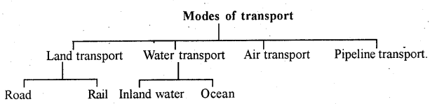
Question 1.
State the different types of Transportation?
Answer:
The Different Types of Transportation are:
- Land Transport
- Water Transport
- Air Transport
- Pipeline Transport.
Question 2.
Name any two different highways of North America?
Answer:
The Highways of North America are:
- The Trans-Canadian Highway.
- The Alaskan Highway.
Answer:3.
Name any two important Trans-continental Railways of Canada?
Answer:
The trans-Canadian Railways are as follows:
- Halifax in the East to Vancouver on the Pacific coast.
- Quebec – montreal industrial region.
Question 4.
Name the two shipping canals of the world?
Answer:
The shipping canals of the world are:
- The Suez
- The Panama canal.
Question 5.
Name nay two major International Airports of South America?
Answer:
International Airport of South America are:
- Rio-de-Janeiro and
- Brasilia.
![]()
Question 6.
Mention any two Inland Waterways in the world.
Answer:
The Waterways in the world is:
- The Rhine waterways
- The Danude waterways.
Question 7.
Mention any two means of modern communication?
Answer:
The means of modem communication is:
(a) Television
(b) Satellites
(c) Computer networking
(d) Internet, Email.
Question 8.
Expand GIS and GPS.
Answer:
GIS = Geography Information system.
GPS = Global Positioning system.
Question 9.
Name any two different highway of Australia.
Answer:
(a) The trans – continental stuart highway – connects Darwin to Melbourne.
(b) The southern highway passes through Kalgoorlie and Koolgardie.
Question 10.
Which is first continental under water railway line when it was opened.
Answer:
Marmary under water railway line. It was opened – In-2013 between Asia & Europe.
Question 11.
Who inaugurated Trans-Siberian railway & when it was opened for Transport.
Answer:
The Czar Nicolson-1891 and opened for transport in 1904.
![]()
Question 12.
Name any two important Trans-Siberian railway in Russia.
Answer:
- Moscow to the Atlantic coast in the West. ’
- Vladivostok along the pacific coast in the East.
Question 13.
Distinguish between Liners and Cargoes.
Answer:
Liners – are ships used for the transportation of passengers.
Cargoes – are the ships carrying only the goods. ’
Question 14.
Distinguish between Tankers and Refrigerators.
Answer:
Tankers – are ships used for the transportation of Petroleum products.
Refrigerators – Ships are used for the transportation of perishable products.
Question 15.
Write the important sea route connects of American side and Asian side.
Answer:
- American side: The north-pacific sea-route connects the ports are Vancouver, Seattle, Portland, sanfrancis co-losangeles.
- Asian.side: Yakohama, Koba, shanghai, Honking, Manila, Singpore.
Question 16.
Write the two canal linkages of Volga waterway.
Answer:
- The Volga – Mascow eanal.
- The Volga – Don canal with the block sea. –
Question 17.
Write the Pecularities of world wide Air routes.
Answer:
- Planes leave from Rome Airport of every 3 minus
- London’s Heathrow Airport is the busiest in the world interms of mail and fright.
- The British Airways is one of the most important which connects the entire world.
Question 18.
What is World Wide Web?
Answer:
It is the Electronic digital World for communicating or accessing information over computer networks.
Question 19.
What is E-mail?
Answer:
A system for sending and receiving messages electronic all over a computer network, as between personal computers.
Question 20.
What is E-Governance?
Answer:
The employment of internet and the World-Wide-Web for delivering government information and services to the citizens.
Question 21.
What is GI.S?
Answer:
Geographical information system designed to capture, store, manipulate, analyze, manage and .present all types of geographical data.
Question 22.
What is GP.S?
Answer:
Global Positioning system is a space based satellite navigation system that provides local and time information in all weather conditions anywhere on the Earth.
![]()
2nd PUC Geography Transport and Communication Five Marks Questions with Answers
Question 1.
Write about the World Road Transport.
Answer:
The Means of carrying Goods & Passengers from One place to another place by Road is called Road Transport.
World Distribution of Road:
- In North America highway density is about 0.65 kms/km, as every place is within 20kms just away from highway.
- The highest road density & the highest number of vehicles are in North America which accounts 33% of the total length of the roads in the world.
- Europe has the good density of road network which connects the entire Western and Central European countries.
- Russia, a vast country developed a dense highway Network in the industrial region West of urals with Vladivostok in the east.
- Asia has a good Networks of roads. A great highway connects from Turkey in the west to Malaysia in the east through India. In India N.H-7 connecting Varanasi from the north to Kanyakumari in the south is the longest road way.
- The Longest Road in the World is Pan American highway which connects Alaska- Canada-United States-Mexico.
- Africa has a few number of good quality roads which connects Algiers in the North to Guinea.
- In South America, Brazil has parallel Road along the Eastern coast.
- In Australia 90% of the road network is found along the Coastal Region.
Question 2.
Write a note on the World Water Transport.
Answer:
Water Transportation is ideal for the movements of bulky heavy large quantities of commodities as well as perishable products. As such the oceans are considered as the natural high ways of the world. Some of the important ocean routes are:
- The Northern Atlantic Sea Route: It connects North Eastern USA & North Western Europe, the two industrially developed regions of the World. The North Atlantic Sea Route is the busiest Route in the world and called “The Big Trunk Route”.
- The Mediterreanean Sea Route: This Route passes through the heart of the old world and serves more countries.
- The Cape of Good Hope Sea Route: The Cape of Good Hope Sea Route is the oldest route of the World, Discovered by Vasco-Da-Gama in 1948. Many Ships follow this route to avoid Heavy Taxation at the Suez canal.
- The North-Pacific Sea Route: The North-Pacific sea route connects the ports are Vnconver, Seattle, Postland, Sanfrancisco, Losangles on American side and Yakohoma, Kobe, Shangai, Hanking, Manila, Singapore on the Asia side.
- The South Atlantic Sea Route: The Eastern Coast of South America with Western Coast of South America with Western Coast of Africa and Europe. This route is not well developed. ‘
- Shipping Canals: The shipping canals are most important and plays a crucial role in the World transport pattern. The Major shipping canals in the world are – The Suez and the Panama Canals.
Question 3.
Write the World distribution of railways
Answer:
Europe has the highest density of rail. Network in the world. It has about 4,40,000 kms of railway track.
- Marmary is the first continental under water railway line. It is between Asia and Europe. It is about 13Kms through Bosporus strait (sea of Marama) & was opened in 2013.
- Railways are more in Russia. From Moscow major lines radiating to different parts of the Country.
- North America has one of the most extensive rail Networks accounting for nearly 40% of the World’s total.
- Chile rail route connects the coastal centres, mining centres as well as interior. Peru, Bolivia, Eurador, Colombia, Venezuela.
- In Asia rail Network is the most dense in Japan, China & India. Japan has 20,035 kms of rail routes.
- Africa has 82,000 kms of Railway route in which 18000 kms lies in South Africa alone due to the concentration of gold, diamond and copper mines. Africa has many major railway route which connects Benguela, Katanga, Zambia, Botswana, Zimbabwe.
- The Tranzam-great Churn railway is connecting the Copper mines of Zambia with the port of Dar-es-Salam of Tanzania.
- The Benguela railway links the Copper mines of Zaire with the Atlantic coast ports via Angola.
- The Blue train run for from Cape Town to Pretoria in the republic of South Africa.
- The Algeria, Senegal, Nigeria, Kenya, Ethiopia railway lines connects the port cities to interior centres.
![]()
Question 4.
Write a note on the Mediterranean Sea route.
Answer:
The Mediterraneas sea route: It passes through the heart of the old world and serves more countries. It passes through the Suez Canal, South of Asia and connects South East and East Asia on one hand and also Australia and NewZealand on the otherhand. A variety of products are transported through the route, in this the crudeoil is the most important, west bound product from the Middle east region.
The Suez Canal: It was first visualised by Napolean Bonaparte, but it was constructed by British in Egypt between Port said in the north and Port Suez in the South which connects the Mediterranean and Red Sea. It is.narrpw with 190 kms long & 19 meters deep. It is the gateway to the Indian Ocean and reduces the distance compared to the Cape of Good Hope.
Question 5.
Write about the Trans-Siberian & Trans-Canadian railways.
Answer:
1. The Trans-Siberian Railway system : It lies in Russia. It is the longest in the world. It connects Asia & Europe continents, Moscow with Vladivostok.
- It connects St. Petersberg, Moscow, Yekaterinbug, Tgumen, Omsk, Novosibirsk, Krasnoyarsk, Chita & Vladivostok. The total length of this railway is 9,289 kms.
- The Trans-Siberian Railway was Inaugurated by Czar Nicolson in 1891 & opened for transport in 1904. The Most important train Russio which runs in the Trans-Siberian Railway. It takes 6days and 10 hours to complete the. Journey.
2. Trans-Canadian railway –
- This railway has the length of2,500kms which runs from Halifax in the east to Vancouver on the Pacific coast passing Through Montreal, Ottawa, Winnipeg and Calgary. It was constructed in 1886.
- The Quebec-montreal industrial region & the wheat belt of Prairie region with the coniferous forest region in the North.
- This railway line is the economic artery of Canada through which wheat and meat are exported.
Question 6.
Write a note on the inland waterways of the world.
Answer:
Inland Waterways – The movement of goods, passengers, through rivers, canals, lakes known as Inland Waterways.
The Main Inland Waterways are:
- The Rhine Waterways – The Rhine River flows through Germany & Netherland which is navigable for 700 kms from Rotterdam of Netherlands to Basel in Switzerland.
- The Danube Waterways – This important inland waterway serves Eastern Europe. The river Danube rises in the black forest of Germany flows through many countries.
- The Volga Waterways – The Volga waterway in Russia provides a navigable waterway of 1200 kms and drains into the Caspian Sea. It has two Canal linkages. They are:
- The Volga-Moscow – Canal connects with the Moscow region.
- The Volga-Don – Canal with Black sea.
- The Great Lakes – St Lawrance Seaway. A Unique commercial waterway in the North Eastern Part of America. This waterway has Duluth and Buffalo ports.
- The Missipssipi Waterway – The Mississipi Ohio water way connects interior part of USA with the Gulf of Mexico in the south.
Question 7.
Write a note on the World air routes.
Answer:
- The North America – The Greatest air traffic is found in USA with internal and international flights. It has the top airports like Attanta, Chicago, Losangeles, Dallas.
- South America – It has far air routes.
The Major international airports are:
Rio-de-Janeiro, Brasilia, Saopaulo, Santiago and Buenos Aires. - Africa – It is served by 2 international Airlines.
- The East African air route through London, Rome, Cairo, Nairobi and Johannesbrug.
- SriLanka and South East Asia and the Central air route connects Paris, Capetown, logos.
- Australia – It is a well developed internal and external air services. Sydney is an important international airport.
- Asia – China has external links with other countries of the world. Its enroute location is between Europe, Asia, Australia and Africa.
- The Russian International Air Routes: Russia and other countries of former Soviet Union are well connected by air service. All Countries of the World connects each other through airlines of different comers.
![]()
Question 8.
Describe the Importance of Pipelines.
Answer:
- Pipelines have become more popular for transporting certain products for lpng distances.
- USA has a large network of pipelines. They are transporting natural gas, petroleum and refined products.
- BIGINCH is the famous pipelines which carries pertroleum from Gulf of Mexico to the north-east states.
- About 17% of all commodities is carried through pipelines in USA.
- In Europe pipeline system was laid to distribute refined products from sea ports to inland markets.
- In Africa, Pipe lines are found in Nigeria and other countries to carry crude oil and natural gas production.
- In NewZealand Milk is being supplied through Pipelines from farms to factories.
- China has one of the most impressive networks of pipelines.
- India has good network of pipelines connecting oil ports and gas fields, refineries and markets.
- Turkmenistan in Central Asia. Asia has extended pipelines to Iran and also parts of china. ‘
Question 9.
Explain the importance of Mass communication.
Answer:
- Communication plays a significant role in the Modem World. They create awareness about the policies, programme of developments, learning.
- Adopt new technological innovations in agriculture and industry as well as transportation.
- People can acquire information of day’s affairs of the world.
- It brings out the unity, integrity and stability of the country.
- It helps in the development of cultural, political and social aspects as well as trade and commerce. ‘
- They have laid a base for modem business. Thus, communication plays a vital role in the development of a nation.
- Speed with messages could be sent across the world with in a second.
- The Telephone or Radio are linked the people Worldwide and they can speak each other directly.
- Even today newspaper touch every part of the country as it coves international, national and local news as well as entertainments with other information.
- The radio has its own name by broadcasting news and information which will reach all comers of country and abroad.
- Television allows the audio and video facilities to gain information for public.
- It has a profound role to play in the forecasting of weather, the direction of aircraft, shipping and warning of usual events such as Hirricanes, snow fall and rainfalls as well as floods.
- Rapid communication have great political implication for leaders can speak to people all over the country.
Question 10.
Explain the significance of transportation.
- Transport is a service to facilitate the movements of goods and persons from one place to other by humans, animals and different, kinds of vehicles.
- Transport network is essential for economic development and commerce it helps agriculture, industry, forestry, mining, fishing, animal husbandary etc.
- To carry the raw materials from their source to the industries and the finished goods from industry’ to market.
- It also helps in the promotion of trade. Economic development of a nation.
- Requires the quick and efficient transportation.
- It is also required to establish tourism, conservation of culture and tradition as well as integration of a country.
- Thus “The Agriculture and Industry are the body and bones of the nation, transport and communication are the nervous system. Transport also help in unifying the scattered people of the globe.
Question 11.
Explain Internet, Remote sensing, E-mail and Satellite communication.
Answer:
- Internet: An Interconnected system of networks that connects computers around the world.
- E-Mail : A system for sending and receiving messages electronically over a computer network, in between personal computers.
- Remote Sensing: Remote sensing is the scanning of the earth by Satellite or aircraft to abtain information about it. It is also the gathering and recording of information through aerial Photographs and Satellite images.
- Satellite Communication: An artificial body placed in orbit round the earth or another planet in order to collect information for communication with other purposes.
![]()
Question 12.
Explain the Evolution of transportation in detail.
Answer:
In the primitive days transportation depended largely on animals and human beings the industrial revolution has opened a new era of transportation.
- New machines were invented which have revolutionized the transportation.
- Road and railway tracks were constructed.
- The introduction of air transport reduced the jomey time and the people were brought closer to each other as the wide world has become a global village.
- International Movement of goods is largely handled by Ocean freighters.
- Road transport is cheaper and faster over short distances. ,
- Railways are most suited for large volumes of bulky materials over long distances.
- High valued, light and perishable products are moved by airways.
- Recently Pipelines have become an important means to carry crude oil, natural gas, water and ores.
Question 13.
Explain the Longest Trans-continental railways of the world (The Railway lines moves from east to west or north to south).
Answer:
- The trans-Siberian raiway : It lies in Russia it is Longest in the World. It connects Asia & Europe continents, moscow with Vladivostok its length is 9,289.
- Trans-canadian railway : It has the length of 22,500 kms which runs Halifax in the East to Vancouver on the pacific coast.
- The union and pacific railway: It connects New york on the Atlantic coast to Sanfrancisco on the pacific coast.
- The Chile-Argentina railway: it is the longest railway line in South America. It connects the Buenos-Aires on Atlantic coast and Valparaiso a- major port on the coast of pacific.
- The Australian trans-continental railway : It locates in the southern part of Australia as . the Large interior part of desert. It connects perth & Sydney. ‘
- Northern trans-continental railway : It connects Seattle to Newyork in USA.
- The southern trans-continental railway : It connects Losangles to Newyork.
- The Canadian National railway : Iy connects saint John to Vancouver.
- Trans caucasioan railway : This railway line connects Batum to Kursk.
- Cape-Cairo railway : It connects Cape Town to cairo in Africa.
Question 14.
Describe the important Ocean routes of the World.
Answer:
Ships follows paricular paths are called
- The Nothem Atlantic sea route – It connects north eastern USA and north western Europe. The two industrially developed regions of the world and it is busiest route of the world.
- The Mediterranean sea route – It passes through the heart of old world like Suez canal, South of Asia and connects South cost & East Asia.
- The cape of Good hope sea route – It is Oldest sea route. It begins from western Europe countries along the West coast of Africa around cape of Good hope to connect Australia and Newzealand. –
- The north – pacific sea route – It links the ports on the west coast of North America. It is not well developed.
- The south pacific sea route – This sea route connects western europe and north America with Australia, New-zealand and the scattered pacific.islands.
- The south Atlantic sea route – It connects the Eastern coast of south America with Western coast of Africa and Europe. It is also not well developed.
![]()
Question 15.
Explain the role of Satellite in the communication in detail.
Answer:
Communication through satellites emerged as a new Era in communication technologes.
- Artificial satellites now are successfully even the remote areas of the globe.
- In India ISRO (Indian Space Reasearch Organisation) at Bangalore is responsible for . ‘ satellite building and launching.
- Satellites helps to have STD. ISD, Telegraph, Telephone. Telex, E-Mail, Computer networking, Radio, Television, Internet, GIS, GPS and Remote sensing.
- India has launched INSAT, METSAT and EDUSAT Satellites for different purposes.
- Insat Satellites helps Television.
- Metsat Satellites helps the Meterological Department and Weather forecast.
- Edusat – Satellites helps the education field.
- Billions of people are using the internet : cyber space will expand the Economic and social space of Humans through email – commerce, E – learning & E – governance.
- Development of Telecommunication and Satellite communication has made the world into a samll global village.
![]()