Students can Download 2nd PUC Geography Previous Year Question Paper March 2018, Karnataka 2nd PUC Geography Model Question Papers with Answers helps you to revise the complete Karnataka State Board Syllabus and score more marks in your examinations.
Karnataka 2nd PUC Geography Previous Year Question Paper March 2018
Time: 3 Hrs 15 Min
Max. Marks: 100
Section – A
I. Answer the following questions in one sentence each: ( 10 x 1 = 10 )
Question 1.
Define ‘Human Geography’.
Answer:
According to Ellen C. Semple – “The study of changing relationship between the unresting man and the unstable earth.”
Question 2.
According to 2012 mention the total population of the world.
Answer:
Seven billion population (7 billion).
Question 3.
What is ‘Internet’?
Answer:
An Inter connected system of networks that connects computers around the world.
Question 4.
Which is the first mega city of the world?
Answer:
Newyork is the largest mega city in the world.
![]()
Question 5.
Which state has lowest literacy rate in India?
Answer:
Bihar with 63.82% is the Lowest Literacy state.
Question 6.
Bhakra-Nangal dam was constructed across which river.
Answer:
Sutlej river.
Question 7.
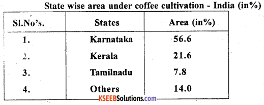
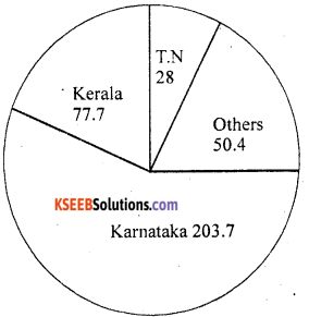
Mention the hightest coffee producing state of India.
Answer:
Karnataka is the hightest coffee producing state in India.
Question 8.
Which is called ‘Liquid gold’?
Answer:
‘Petroleum’.
Question 9.
Which city is called ‘Jawa of India’?
Answer:
The Gorakhpur distric of Uttar Pradesh is known as Jawa of India.
Question 10.
What is ‘Environmental pollution’?
Answer:
Environment Pollution means the release of Harmful substances and contamination of environment.
![]()
Section – B
II. Answer any 10 of the following questions in 2 to 3 sentences each: ( 10 × 2 = 20 )
Question 11.
Mention any four primary economic activities.
Answer:
- Primary activities
- Secondary activities
- Teritiary activities
- Quatemary activities.
Question 12.
State the importance of industries.
Answer:
- Industries helps in removing poverty and unemployment.
- The economic strength of a country is judged by the develepment of its industries.
- It contributes about 78 percent of our foreign exchange earning.
- Industries involve from the making of Machines euipement and tools for the automobiles, ships, aircrafts etc.
Question 13.
Write any four probblems of rural settlements.
Answer:
Some of the most important common problems of rural settlements are –
- Supply of water is most inadequate. People in the rural areas particularly in mountain and desert region walks for long distances to Fetch drinking water.
- The Water borne disease such as cholera, jaundice etc, are the common problems.
Many rural areas are facing the problems of natural diasters which occur frequently such as floods and droughts. - Agriculture areas are severely affected due to lacking of irrigation.
- Being dominated by agriculture the effects of droughts are severe and have effects which strech for many years.
- The rura1houscs are lacking toilet and disposal facilities of solid aster/garbages which cause health related problems.
- The houses are made up of mud, wood and thatch which are damaged by heavy rains & floods. They require proper maintainance every year.
- Most of the houses do not have proper ventilation and the design of the houses also includes animaL shed with fodder storage.
- The rural settlements are lacking roads and other modern communications.
Question 14.
What is migration? Give any one reason of migration.
Answer:
The movement of people from onc place to another place is known as Migration.
Causes of Migration : Migration is caused by a variety of factors including economic, social and political factors. Some of them are briefly discussed below.
- Marriage: Every girl has to migrate to her husband’s place after marriage, thus the entire female population of India has to migrate over short or long distance.
- Employment : The agricultural base of rural areas does not provide employment to all the people living here. In contrast, urban areas provide vast scope for employment in industries, trade, transport & services. Hence people like to migrate towards the urban areas.
- Education : Educational facilities are very low in the rural areas especially those of higher education and rural people have to migrate to the urban centers for this purpose.
- Lack of security: Large number of people have migrated out of Jammu and Kashmir and Assam during the last few cars due to disturbed conditions there. In this situation, people would like to migrate towards well secure areas.
![]()
Question 15.
Mention the types of canal irrigation.
Answer:
- Inundation canals :- taken out direct1 from ivers without making any barrage or dam.
- Perennial canals :- which are taken Out from the reservoirs by constructing barrage.
Question 16.
Mention the benefits of rainwater harvesting.
Answer:
- It involves collection and storage of rain water at surface or in Sub-surface aquifer before it is lost as surface run off.
- It is not only increase water availability but also check the declining water table.
Question 17.
What is ‘Mixed farming’?
Answer:
Raising of food as well as commercial crops and keeping of lives stock is called “Mixed farming”. It has been introduced in 1951.
Question 18.
Name the types of coal.
Answer:
The types of coal arc:
- Anthracite
- lignite
- Bituminous
- Peat.
Question 19.
Discuss the factors necessary for the production of Hydro-electricity.
Answer:
- The regular and uniform supply of water is essential.
- The water should fall from a sufficient height.
- It requires huge capital investment to purchase machines.
- A ready available market should be there.
Question 20.
Give any two examples of Agro-based industries.
Answer:
- Cotton textile industries
- Sugar industries
- Jute industries.
Question 21.
What are the main four items importing of India?
Answer:
Imports of India : Imports trade of India refers to buying goods from foreign countries and bringing them to home country.
The main items of Imports of India are:
1. Petroleum crude and products :
- It is the most important materials of Indian, Imports.
- In 2006-2007 India imported rupees 2,58,572 crores worth of crude oil and other petroleum products.
- It contributed 23% of our total imports.
2. Pearls precious and semi-precious stones :
India imported rupees 33,881 crores worth of precious stone.
3. Capital goods :
In 2006-2007 India imported rupees 2,51,136 crores worth of capital goods.
4. Fertilizers :
India is a major importer of chemical Fertilizers. It is because the country is agrarian and the Internal production of fertilizers is insufficient. Potash fertilizers are largely imported.
Exports of India : Export trade of India refers to the sale of goods and services by India to other countries of the world.
The main items of our exports are as follows:
- Agricultural and Allied products: Products such as cereals, pulses tobacco, spices, nuts and seeds, oil meals, caster oil etc.
During 2011-2012 exports income is about US dollar 13300.63 million. - Ores and minerals: Export of ores and minerals like Iron ore, Manganese, Micca was estimated at US dollar 4700.29 million during 2011-12.
- Gems and Jewellery: India imports gems and precious stones in their raw form and exports them after proper cutting and polishing.
- Electronic goods: Items under this group. of consists of machinery, iron, steel and other engineering items.
- Petroleum products: Export of petroleum products increased to US dollar 34667.02 million.
![]()
Question 22.
Mention the two sources of solid wastes.
Answer:
- Household or Domestic establishment
- Industrial. or Commercial establishment.
Section – C
III. Answer any eight of the following questions in 25 to 30 sentences each: ( 5 × 8 = 40 )
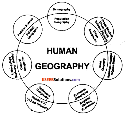
Question 23.
Explain the branches of Human Geography.
Answer:
The important branches of human Geography are as follows-
- Economic Geography: It deals with the study of influence of Geographical factors on the economic activities man like agriculture, industries, transport etc.
- Po1itica1 Geography: It deals with the influences of geographical environment on political aspects such as states nations & boundaries etc.
Question 24.
What is the growth of population? Explain the distribution of population in the world.
Answer:
The growth of population refers to the increases in the number of inhabitants of a country during specific period.
- It is estimated that the world population reached one billion for the first time in 1804.
- Due to the impact of the industrial revolution & improvement in living standards, the rate of population growth increased two billion in 1927.
- At present estimate of 2013 the globe is inhabited by 7121 million population.
- During the begining of 20th century the world population was only 2 billion and century ended with 6 billion. It continues to grow even in the 21st century.
Stages of Population growth:
I Three billion – July 1959
II Four billion – April 1974
III Five billion – July 1987
IV Six billion – 12th October 1999
V Seven billion – 12th March 2012.
Question 25.
What is ‘Demographic cycle’? Explain its different stages.
Answer:
Demographic cycle is the process of population transformation from the countries of high birth rate and high death rates to low birth rate & low death rate countries.
Stages of Demographic cycle:
- First stage: High birth rate and high death is found when the country ¡s economically most backward, so the population remains stationary. India was in the stage till 1920.
- Second stage (Early expanding): It begins with the declining of death rate while the birth rate ramins unchanged. These changes due to the advancement of science & technology, basic health care and education etc. At present many developing countries of Asia & Africa are in this stage.
- Third stage (Late expanding): Death rate declines and birth rate begins to fall due to access of contraceptives, urbanization, an increase in the status and women education etc India appears to be this stage.
- Fourth stage (Low stationary): It is characterized with low birth rate and low death rate. Growth is stationary due to changing life style, high obesity and many diseases are caused in this stage. Japan, Sweden, Belgium Denmark & Switzerland are in this stage.
- Fifth stage(Declining): Population begins to decline or birth rate is lower than deathrate. East European countries like Germany and Hungary and North European countries like Sweden. Norway are now in this stage.
Question 26.
Write a note on modes of communication.
Answer:
- Communication plays a significant role in the Modern World. They create awareness about the policies. programme of developments, learning.
- Adopt new technological innovations in agriculture and industry as well as transportation.
- People can acquire information of day’s affairs of the world.
- It brings out the unity, integrity and stability of the country.
- It helps in the development of cultural, political and social aspects as well as trade and commerce.
- They have laid a base for modern business. Thus, communication plays a vital role in the development of a nation.
- Speed with messages could be sent across the world with in a second.
- The Telephone or Radio are linked the people Worldwide and they can speak each other directly.
- Even today newspaper touch everypart of the country as it covers international, national and local news as well as entertainments with other information.
- The radio has its own name by broadcasting news and information which will reach all corners of country and abroad.
- Television allows the audio and video facilities to gain information for public.
- It has a profound role to play in the forecasting of weather, the direction of aircraft.
shipping and warning of usual events such as Hirricanes, snowfall and rainfalls as well as floods. - Rapid communication have great political implication for leaders can speak to people all over the country.
Question 27.
Explain the measures to check the growth of population in India.
Answer:
The government of India has taken several steps to control the growth of population in the country are as :
- Family Planning Programme : India was the first country in the world to adopt the family planning programme in the year 1952. The main aim is to control births by various means such as free sterilization (Vasectomy for males Tubectomy for females). Adopting contraceptives etc.
- Improvement of the status of women : The social, economic and political status of women have been improved through education and various women welfare scheme. For ex: In Karnataka free Education, Government jobs, Bhagyalaxmiyojana etc.
- Programmes to control infant mortality : The government of Karnataka has introduced many child welfare programmes to control infänt mortality. For ex: Jananisurakshayojan, Madilu Prasooti Araike etc.
- Area Projects : Under this project health worker visit door to door and advise. In addition they are also motivating the people to adopt contraceptives and undergo sterilization.
- Publicity : Broadcasting the benifits of small family through the Radio, Television and Ne spapers etc.
Question 28.
What are the types of migration? Analyse types of internal migration of India.
Answer:
The types of Migration are Internal Migration and International Migration.
I. Internal Migration :
Movement of people fiom one region to another within the same country is called internal
migration. In India there are four streams of mternal migration. They are
- Rural to Rural
- Rural to Urban
- Urban to Urban
- Urban to Rural
1. (a) Rural to Rural : This is estimated that about 65.2% of total migration is of this category.
Female migrants dominated in this stream, Thus it is an important example for matrimonal migration and it is called women migration.
2. Rural to Urban : Rural to Urban migration (17.6%) is second important type of migration.
Rural – Urban migration is caused b both push of the rural areas as well as pull of the urban areas.
3. Urban to Urban : Generally, people like to move from small town with less facility to large cities ith more facilities.
4. Urban to Rural : Urban areas are usually affected by the pollution.
The retired and aged people prefer to spend their old age life in nearby villages. Thus people move from ltrban to Rural.
2. International Migration : Movement of people from one country to another across international borders is called International migration.
Question 29.
Describe the land – use pattern of India.
Answer:
The important types of land use pattern in India are:
- Forest area
- Land not available for cultivation
- Cultivable wasteland
- Fallow land
- Net area sown.
1. Forest area : –
- According to National Forest Policy 1952, reporting area of the forest must be 33.3% of the total land.
- Madhya Pradesh, Arunachal Pradesh, Odisha, Maharashtra. Andhra Pradesh, Andaman Nicobar. Islands are reporting more area under forests.
- It is due to heavy rainfall and relief features.
2. Land not available for cultivation :
- The land used for human settlements, transport routes, canals, quarries, the mountains, deserts, marshes etc, are coming under this category. It accounts 14.2% of the total land in India.
- Arunachal Pradesh. Rajasthan, Gujarat and Madhya Pradesh, states are having more area under this category.
![]()
Question 30.
Write the types and distribution of cotton crop in India.
Answer:
Conditions for Cultivation of cotton:
- Cotton is a tropical & Sub-tropical crop. It requires high temperature. At the time of growing it requires 21°C to 24°Ç temperature.
- It requires moderate rainfall of 50 cm to 100 cm. However, it can cultivate in areas of lesser rainfall with the help of irrigation.
- Deep black soil is well suitable for cotton crop. This soil is commonly known as Black cotton soil. This is capable of retaining moisture.
- Cotton requires the use of Manures & fertilizers crop rotation helps to maintain fertility of the soil & improve the yield.
- Cotton cultivation requires large amount of cheap labours for planting, thinning, seeding, picking of cotton.
- Frosting, Moist weather & heavy rainfall are harmful to the crop.
- Cotton plant is susceptible to disease & pests. Site requires the use of insecticides & pesticides.
- The Sunny weather is necessary at the time of harvesting the cotton.
Varieties of Cotton:
(1) Long Staple Cotton:
- It is the best variety
- It has over 3.8 cm in length.
- Because of its length of fibre, fine & shining it is used for making fine & super fine quality of cloth.
- It is Largely grown in Punjab, Haryana, Maharashtra, TarnilNadu & MadhyaPradesh etc.
(ii) Medium Staple Cotton:
- The length of catton fibre is between 2.5 cm to 3.8 cm is known as medium staple cotton.
- It is used for making Medium cloth.
- his is grown in Rajasthan, Punjab, TamilNadu, Madhya Pradesh, Uttar Pradesh, Karnataka etc.
(iii) Short Staple Cotton:
- This is infèrior variety with fiber length less than 2.5 cm.
- This used for making inferior quality of cloth, stuffing purpose, blending with synthetic, fibre etc.
- This type of cotton production is reduced in India.
- Uttar Pradesh Andhra Pradesh & Rajasthan etc are growing this type of cotton.
Question 31.
What is ‘Green revolution’? Discuss the advantages of green revolution in India.
Answer:
Increase in Food production through the introduction of high yield crop varieties and the application of modem agricultural techniques is called Green Revolution.
- Increase in Agricultural production and yield per hectare.
- Better land use by employing two or three crop pattern.
- Reduction of imports of food grains.
- Improves country’s Economic status.
Question 32.
Explain the four major types of roads in India.
Answer:
Classification of roads: In India, roads are of the following types.
- National highways
- State highways
- District roads and
- Village roads.
Besides these, there are border roads and International highways linking major Indian cities with the capitals of other neighbouring countries.
National highways:
- They connect the capitals of the states, industrial centres and major ports.
- They are bell planned wide roads with two-lane, four-lane, and six-lane roads. Both construction and maintenance are carried out by the Central Government and National Highway Authority of India [NHAI].
- The total length of the national highways is about 71, 772 km as per 2011
- (i)The Golden Quadrilateral, (ii) The North South and East-West corridors, (iii) Port connectivity with industries are all part of this network.
Golden Quadrilateral Super Highway: The Governmcnt of India has implemented a major road development project linking Delhi-Kolkata-Chennai-Mumbai by six-lane super high-ways. It has a total length of 5846 kms and it is called as Golden Quadrilateral Super Highway.
North – South and East-West corridors: This project connects Srinagar (JK) in the North with Kanyakumari (TN) in the South and Silcher(Assam) in the East with Forbandar (Gujarat) in the West covering major cities along the way. The project has a total length of 7300 km.
Port connectivity project: This is also included in the programmes of NHAI. This project connects the Golden Quadrilateral roads with the 13 major ports (380 km) and other projects (962 km). This is still in progress.
State highways: The State Highways connect the important cities of the state with its capital. with the national highways and link with other slate capitals. The State Government is responsible for the construction and maintenance of the State Highways. Now there are about 1.54. 522 km length of the state highways in the country.
District roads: These roads connect the production and marketing centres with the highways, railways, towns and larger villages with the district headquarters. The Zilla Parishad takes the responsibility for the development and maintenance of these roads.
Village roads: Roads which link the Taluk headquarters with villages and the district highways are called village roads. They are mostly untarred or metalled, They are constructed and maintained by Taluk Panchayats and Village Panchayats.
Border roads: Border roads are constructed in the border areas of the country. They are constructed in the North and North eastern border areas adjoining Pakistan. Nepal. Bhutan and Bangladesh. These are mainly for army movement in the defense of the country.
International highways: Some of the national highways of the country have been linked with the international highways of the neighbouring countries.
Question 33.
Why railway transport is very important in India? Discuss.
Answer:
Importance of Railways : Indian Railway have benefited our country in the following ways.
- They have helped in the commercialization of agricultural sector through the movement of perishable goods, necessary inputs and implements.
- They help the industry by transporting raw-material, labour, fuel by distribution and ( marketing.
- Railways are useful for carrying bulky and heavy goods for long distance.
- Railways are promoting the movement of goods and passenger traffic.
- They are helping in unifying the national market by stimulating the process of equalization of prices.
- They are promoting the development of the foreign trade.
- They are helping in the process of better administration, understanding and national intergration.
- It helps tourism by connecting places of tourist interest.
- Our railway also help to strengthen the Law and Order situation in the country.
Question 34.
Explain the sources of water pollution.
Answer:
Causes of water pollution: Water pollution is caused by natural and human sources.
- Natural sources of water pollution are due to erosion, landslides, gases, soil, minerals.
- Human excreta, waste created by animals and other living organisms and rotting vegetation
are also some causes. More than natural sources, water pollution is largely caused by human activities. - Humans pollute water through industrial, agricultural and cultural activities. Among these, industry is the worst culprit.
- Industries produce a variety of waste products including industrial wastes, polluted water wastes, poisonous gases, chemical residuals, numerous heavy metals, dust, smoke etc.,
- Most of the industrial wastes are disposed off by running water. Consequently poisonous elements reach the lakes, river and other water bodies, which destroy them.
- Reservoirs -They in turn destroy the bio-systems of the water. Major water polluting industries are leather, pulp and paper, textiles and chemicals.
- Fertilizers, pesticides and insecticides, farm wastes and mineral particles from agricultural lands are washed down and end up in rivers, lakes and tanks.
- The chemicals also infiltrate into the soil to reach the ground water.
- Addition of fertilizer increases the nitrate content of surface waters.
- Religious and cultural activities like pilgrimages, fairs, tourism, immersiOn of idols after pujas etc., also cause water pollution,
- Urban activities such as improper sewage disposal also cause water pollution.
- Effects of water pollution: Water pollutants adversely affect the health of humans, animals and aquatic life.
- Water pollution is a source of various water borne diseases like diarrhoea, intestinal worms, hepatitis etc.
- World health organization shows that about one fourth of the communicable diseases in India are disease water borne.
IV. Answer any one of the following questions : ( 1 x 10 = 10 )
Question 35.
Explain the types of agriculture in India.
Answer:
Various types of farming are practised in different parts of the country. They are as follows :
- Primitive subsistence farming
- Migratory subsistence farming
- Sedentary subsistence farming
- Intensive farming
- Commercial farming
- Mixed farming
- Plantation farming
- Dry farming
- Humid farming
- Irrigation farming
1. Primitive Subsistence Farming : The production of crops for the purpose of domestic consumption and not for commercial use is called “Primitive subsistence farming”. Farmers -used primitive methods of cultivation. This types of farming is widely practiced in hilly regions like North-easterns states, Odisha and Madhya Pradesh. Primitive subsistence farming can be classified into two types. They are –
(i) Migratory subsistances farming and (ii) Sedentary subsistence farming.
(a) Migratory subsistances farming : It is a primitive method of farming, practised by tribals in the tropical rainy forests. Under this system formers clear patches of forest by cutting and burning the bushes and trees and cultivate land. Later people migrate to another parts of the forest. Along with cultivation of crops, hunting, fishing and collection of forest resource etc are done by the people.
This type of farming is called by different local names-eg- ‘ Jhumming’ in North Eastern regions(Assam), ‘Koman’ in Odisha, ‘Ponam’ in Kerala, and ‘Podu’ in Andhra Pradesh. Yams, Peanuts, beans, bananas, upland rice, buck wheat, maize, millets and sometime vegetables are grown under this farming. This farming is practiced in Assam, Meghalay, Nagaland, Manipur, Tripura, Mizoram, Arunachal Pradesh, parts of Madhya Pradesh, Odisha and Andhra Pradesh.
(b) Sedentary subsistence farming : This is an ancient form of cultivation and practiced by the people living permanetly. Here there is physical factors are favourable for cultivation, of land. The farm lands are not abandoned. They are cultivated through of the year and farmer lived near the land. Hence, this system is called “Sedentary subsistence farming”. Under this system, implements used and the mehtods Of cultivation are primitive. The surplus agricultural produce are sold to neighbouring people or sold in the market.
Sedentary subsistence farming also includes the rearing of animals for milk, meat, woo! and hides.
2. Intensive farming : It is found in the areas of dense population and land holdings are small. in this type of farming land in intentively used and 2-3 harvests are obtained in year. It is known as “Intensive farming”.
It is labour and capital Intensive farming. Large amount of labour and capital is used on a small land holding, to get maximum production of crops. The available small piece of land is ised for cultivation with irrigation facilities throughout the year. In this system, farmers try to raise two or more crops, with careful tilling of the soil. Intensive agriculture is characterized by high yields per unit area and farmers try to get the maximum production from small land holdings. It is common in the fertile and irrigated parts of the country. In this type, agricultural operations are carried on by manual labour and draught animals. Rice is the main crop of Intensive farming in India.
3. Commercial farming : Agricultural crops are produced on a large scale.for the purpose of sale and not for domestic consumption, is called ‘Commercial farming’. This type of farming is generally practised in the large areas of sparse population with good transportation facilities. On large scale farms, using small amount of labour, large scale use of machinery, cash crops are growth for scale.
4. Mixed farming: Farming that includes the raising of crops and keeping of livestock is called ‘Mixed farming’. In this system farmers use the land for raising food as well as commercial crops and also used for other purposes such as livestock-raising, poultry farming, sericulture, bee-keeping etc. Farmer get more income from both side. It has been introduced in India since 1951. It is popular in the states like, Rajasthan, Andhra Pradesh, Punjab, Haryana and Tamil Nadu.
5. Plantation farming: A single cash crop is grown on large area or estates is known as ‘Plantation farming’. This is mainly a commercial type of farming. It requires large amount of labour and capital. Manual labour and skilled labour is important. Under this system crops are grown mainly for export. The important plantation crops of India are Tea, Coffee and rubber.
6. Dry farming : The farming system practised in areas which receive scanty rainfall (i.e, less that 50 cms) and irrigation facilities are very limited or absent is called ‘Dry farming’. This type of farming is practiced in Deccan plateau of south India, Western Rajasthan and other arid and semiarid regions. Famines and droughts are common in these regions. Crops are growing with low yield. Only quick maturing and drought resistant crops are cultivated. Jowar, bajra, ragi, oilseeds are the important dry farming crops.
7. Humid farming: Cultivation of crops, where the areas receiveing sufficient rainfall without the help of irrigation is known as Wet farming or Humid farming. If the rainfall is sufficient i.e. 100 to 150cms throughout the year, double or multiple cropping is practiced in that area. Rice, sugarcane, Jute, tea, coffee, rubber etc, are grown. Sufficient rainfall helps to obtain higher yields and better quality of crops.
8. Irrigation farming: Cultivation of crops with the help of Irrigation is called ‘Irrigation farming’. This type of farming is very essential to India, because monsoon rainfall is seasonal, uncertain and insufficient. The largest area of cultivated land is under irrigation in India. This type of farming is highly concentrated in Uttar Pradesh, Punjab, Haryana, Bihar, Odisha, West Bengal, Andhra Pradesh, Tamil Nadu and Karnataka, and also practiced in many other states of the country.
Question 36.
Explain the major industrial regions in India. –
Answer:
Industrial region refers to the continuous development of industrial landscape, over a large area by concentration of a number of factories of different industries. in short, it is a wide area of manufacturing industries. :
1. Mumbai-Pune Industrial regions: It is the biggest and most important industrial region of the country. Opening of the Bhorghat to Pune in 1830, opening of steamer service through Suez Canal in 1843, opening of first railway line of 32 km in 1853 between Mumbai and Thane etc. Supports lot of development of industries in this region by the British who got the Mumbai island as marriage gift of Catherine Braganza’s dowry in 1661.
2. Kolkata-Hooghly Industrial region: It is an old atid important industrial region of the country. Kolkata is the main centre for Hoogigly basin, port., rich hinterland of Ganga and Bramaputra plain, Assam and Bengal tea plantations, coal and iron ore region of Chotanagapur plateau. Cheap labour from West Bangal Bihar, Orissa states. effecient transport by rail, road and waterways etc. are the important facIIitis supported to dc elop
this region.
3.Ahmedabad-Vadodara Industrial region : It is thrid largest industrial region of the country. It is located in Gujarat and includes the areaš around the Gulf of Khambhat and important industrial centres like Ahmedabad, Vadodara, Koyali, Baruch and Surat et. Ahmedabad is the main centre for cotton.textiles, woollen and silk, textiles, paper, petrochemicals milk products, Engineering, diesel engines, oil refining etc.. åre the other important industries of this region.
4. Madurai-Coimbatore-Bangalore Indusrial regiòns : This region lies in Tamil nadu and Kaniataka states. The important centres are Bangalore, Chennai. Coimbatore, Madurai, Sivakasi, Tiruchirapalli, Salem, Mysore, Mandya, Bhadravathi etc. The region hasdiversified Industries like cotton textiles, silk, sugar, leather, chemicals, machinery, rubber, electrical equipments telephone, railway coaches, Information Technology. Bio- Technology etc.
5. The Chotanagapur Plateau Industrial regions : This region is located in the states of Bihar, parts of Jharkhand and West Bengal. This region is called the Ruhr of India on account of the growth of a number of iron and steel plants and various engineering industies. Jamshedpur, Bokaro, Chittaranjan, Sindri, Durgapur, Hazaribagh etc are the important industrial town in this region.
6. The MatburaDelhi-Saharanpur-Ambala Industrial regions : This region covers Uttar Pradesh, parts of Haryana and Delhi. It includes Agra, Saharanpur, Faridabad, Ambala, Delhi, Modinagar, Ghaziabad, Ferozabad, Noida., Meerut, Math ura, Pan ipat etc. Delhi is the most important centre for the Industries of cotton textiles, glass, chemicals, automobiles, engineering, paper, soap, vanaspati, sugar and oil refineries. The region is facing the problem of environmental pollution.
Section – E
V. Answer the following questions: ( 2 x 10 = 20 )
Question 37.
Construct a Pie-Diagram by using the following date :
Answer:
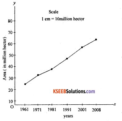
Question 38.
Construct a simple line graph by using the following data.
Growth of irrigated area in India 1961 to 2008
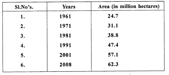
Answer:
Question 39.
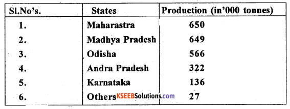
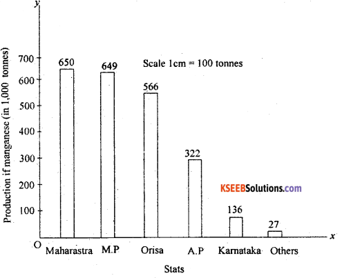
Construct a simple bar graph by using the following data.
State wise production of manganese in India. 2011-12 (in thousand tonnes)
Answer:
For Blind Students only
Answer any two of the following : ( 2 x 10 = 20 )
Question 37.
Explain the primary sources of data.
Answer:
Meaning – The data which are collected for the first time by a researcher or groups of researchers, institution or organizations are called Primary sources of data.
Types of Primary data collection:
- Through Personal interview : Personal interviews are the most commonly used method of collecting data, because the interviewer has the opportunity of explaing the study and answering any question, here the researcher gets direct information from the respondents.
- By Personal observations: It refers to the collection of data or information by individual or group of individuals, through direct observations in the field.
- By Questionnaire : The most common method used in surverys is the Questionnaire. In this method, simple questions and their possible answers are written on a plain paper, and the respondents have to tick mark the possible answers from given choices.
- Others methods :
- Telephone interview : In this method, the researcher/interviewer can collect the information over the telephone.
- Measuring properties: In this method, the data about properties of soil nd water collected directly from the field by measuring their characteristics using soil and water quality kit.
Question 38.
Explain the segment of GPS
Answer:
There are three segments of GPS:
1. The space segments : The satellites of GPS are launched and positioned at an altitude of approximately 20200 km which is almost more than three times of the earth’s radius. The space segment consists of a constellation of 24 functioning GPs satellites located in 6 orbital plane with 4 satellites in each orbital plane. The time for the satellite to complete one revolution around the earth is 11 hrs and 58 minutes.
2. The control segment : The control segment consists of facilities necessary for satellites especially healthy monitoring, telemetry, tracking command and control clock error computation of satellites. There are 5 GPS stations spread over the earths surface they are-
- Hawaii
- Colorado spring
- Ascension island
- Diego Garcia
- Kwajalein.
3. The user segment : it is a total user and supplier community, both civilian and military. The user segment consists of all earth – based GPS receivers. Receivers very greatly in size and complexity, through the basic design in rather simple. The space and control segments are largely transparent to the operations of navigation functions.
- Navigation : In navigation, by using GPS can save countless hours in the field. Any feature, even if it is under water, can be located upto one hundred meters simply by scaling coordinates from a map, entermg way points & going directly to site.
- Remote sensing and GIS : GPS positioning can be intergrated into remote – sensing methods such, as Photogrammetry and aerial scanning, magnetometry, and video technology using DGPs techniques.
- Surveying/Mapping : The high precision ofGPS carries phase measurements, together with appropriate adjustment algorithum, provides an adequate tool for a variety of tasks for surveying and mapping.
- Geodescy : Geodetic mapping and other control surveys can be carried out effectively using high grade GPs equipment.
- Military : The GPs was Primarily develped for real time military positioning. Military applications include airbone, marine and land navigation.
Question 39.
Write the importance of remote sensing.
Answer:
Remote sensing is the science and art of obtaining information about an object, area or phenomenon through the analysis of data aquired by a device that is not in contact with it.
This is done by sensing and recording reflected or emitted energy and processing, analyzing and applying that information.
In much remote sensing. the process involves an- interaction between incident radiation and the targets of interest. This device can be a camera or a bank of sensors operated from an airplane or a satellite. Though satellite we can collect date related agriculture, forest, urban land use, watcr, natural calamities etc the satellite data is based for mapping, monitoring, studyIng the various phenomena related to earth’s surface.