Students can Download 2nd PUC Geography Model Question Paper 1 with Answers, Karnataka 2nd PUC Geography Model Question Papers with Answers helps you to revise the complete Karnataka State Board Syllabus and score more marks in your examinations.
Karnataka 2nd PUC Geography Model Question Paper 1 with Answers
Time: 3 Hrs
Max. Marks: 100
Section – A
I. Answer the following in one sentence each: ( 1 × 10 = 10 )
Question 1.
Name any two countries which have highest birth rate in the world?
Answer:
- Neger – 51.26 briths per 1000 Population
- Chad-47 births per 1000 Population.
Question 2.
What is Mining?
Answer:
Mining refer to the Extraction of the minerals from the Earth such as Iron ore, Manganese. Gold, Coal, Diamond and Petroleum.
Question 3.
Name the first artificial satellite lounched by Russia?
Answer:
‘Sputnik’ on 1957.
Question 4.
Define Mega city?
Answer:
Mega city is a metropolitan area with total Population of more than 10 million People.
![]()
Question 5.
Which state has highest Sex – ratio in India?
Answer:
Kerala (1084 females for every 1000 males) accordings to 2011 census.
Question 6.
Name the dam which was constructed across the river Sutlej Himachal Pradesh?
Answer:
Bhakra – Nangal dam.
Question 7.
What is tissue culture?
Answer:
The growing of cell or tissue or an organ in an artificial aseptic and nutritive medium is called “Tissue culture”.
Question 8.
What for Digboi is famous?
Answer:
The first oil well was drilled at Digboi. And Major oil fields of Assam state are in Digboi.
Question 9.
Where was the first cotton industry established in India?
Answer:
The first modem cotton mill was setup in 1818 at ‘Fort Glaster’ near Kolkata.
Question 10.
On which river bank Kolkata Port located?
Answer:
On the Hoogly river 148km from the sea.
![]()
Section – B
II. Answer any ten the following in 2-3 sentences each: ( 2 × 10 = 20 )
Question 11.
Differentiate between secondary and tertiary activities?
Answer:
Secondary activities:- the processing and conversion of raw materials into useful Products are concidard as secondary activities.
Tertiary activities:- where as tertiary sector is basically the part of the economy that helps both the sector of primary and secondary it includes all kinds of services.
Question 12.
Why lumbering has developed in cold temperate regions?
Answer:
Coniferous forest region is ideal for the gathering forest products for livelihood by man which is found in cold temperate region. So it encourages largely on this part of the world.
Question 13.
Mention any two cultural and religious towns of the world?
Answer:
- Mecca
- Rome
Question 14.
Name two states of highest and lowest HD I in India.
Answer:
Kerala has a highest and Chhattisgarh has a lowest HDI in India.
Question 15.
Name the varieties of coffee?
Answer:
- coffee Robusta
- Coffee Arabica
- Coffee liberica
Question 16.
Mention any four metallic minerals?
Answer:
- Iron ore
- Copper
- Manganese
- Bauxite
Question 17.
Distinguish between conventional and non-conventional energy sources.
Answer:
The resources which cannot be used again and again for example, coal, petroleum natural gas are called ‘conventional power resources” in contrast, the resoures which can be use again and again forex: Solar, wind, tidal, Hydro electricity etc. are called ‘non conventional power resources”.
![]()
Question 18.
Mention the major sugar Producing states of India?
Answer:
- Uttar Pradesh
- Maharashtra
- Tamilnadu
- Karnataka, Andhra Pradesh, etc.
Question 19.
Write the advantages of Rail transport?
Answer:
- They help the industry by transporting raw – material,-labour, fuel by distribution and . marketing.
- Railways are promoting the movement of goods and passenger traffic
- They are promoting the development of foreign trade
- It is the cheapest means of surface transport to carry the bulky goods for the longer distances.
Question 20.
State the commodities of exports from India?
Answer:
Plantation crops, agricultural and- allied products, ores and minerals, chemical and related products, textiles, electronic goods, Information technology etc are the’ important exports of India.
Question 21.
What are the causes for air pollution?
Answer:
- Increased use of varieties of fuels such as coal. Petrol, and diesel.
- increase in emission of Toxic gases from industrial activities into the atomosphere.
- Mining activities release dust in the air.
- Important pollutants are oxides of sulpher and nitrogen hydro carbons dioxide, carbon monoxide lead and asbestos
Question 22.
Define sustainable development with examples?
Answer:
The term sustainable development is defind as development to acheive the needs of present generation without compromising future generation.
Ex: Sustainable development takes care of ecological, social and economic aspects of development.
Section – C
III. Answer any eight of the following in 25-30 sentences each: ( 5 × 8 = 40 )
Question 23.
Explain the scope of Human geography?
Answer:
Scope of Human geography.
As early societies become more successful in meeting their needs with in Permanent settlements.
- The rise of agricultureing activities led to more complex economic and political boundaries were created and more settlement grew into towns and cities.
- The physical environment also changed with the influence of modem urbanized and industrized world that we known today.
- One of the greatest challenges faced by humans today is how to manage energy resources in a sustainable fashion with our inflicting permanent damage to environment in the form of land, air, water, pollution and climatic changes.
Question 24.
Explain the distribution of population in the world?
Answer:
The population of the world is
unevenly distributed. The distribution of population is expressed in terms of density. The density is the ratio between the numbers of people to the size of land. Distribution of 0C£M population of the world has been divided into three regions.
(a) Area of high density
(b) Area of medium density
(c) Area of low density

1. Area of high density: The three principal high density zones are:
- Eastern, southern and south – eastern part of Asia.
- North – western part of Europe
- North – Eastern part of USA and south eastern part of Canada.
2. Area of Midiun density: The population moderately dense in tropical regions of the world and the moist temperature regions of the Argentina south East Africa and eastern Australia.
3. Aiea of low density: The area which are nearest to the north and south poles, hot and cold desertes and high rain fall zones near the equator have very low density of population.
- Asia is the most populous continent. It accounts about ’61 present’ of the world population.
- Africa is second most populated continent with 13 percent
- Europe has 12 percent
- South America 8.5 percent
- Northern America 5 percent
- Oceania is the least – populated region which has 0.5 percent
- Antarctica is uninhabited permanently.
![]()
Question 25.
Explain the demographic cycle?
Answer:
Demographic cycle is the process of population transformation from the countries of high birth rate and high death rates to low birth rate & low death rate countries.
Stages of Demographic cycle:
- First stage: High birth rate and high death is found when the country is economically most backward, so the population remains stationary. india was in the stage till 1920.
- Second stage (Early expanding): It begins with the declining of death rate while the birth rate ramins unchanged. These changes due to the advancement of science & technology, basic healthcare and education etc. At present many developing countries of Asia & Africa are in this stage.
- Third stage (Late expanding): Death rate declines and birth rate begins to fall due to access of contraceptives, urbanization, an ilicreascE in the status and women education etc India appears to be this stage.
- Fourth stage (Low stationary): It is characterized with low birth rate and low death rate. Growth is stationary due to changing life style, high obesity and many diseases are caused in this stagé. Japan, Sweden, Belgium Denmark & Switzerland are in this stage.
- Fifth stage(Declining): Population begins to decline or birth rate is lower than deathrate. East European countries like Germany and Hungary and North European countries like Sweden, Norway are now in this stage.
Question 26.
Write a note an water transport?
Answer:
Water Transportation is ideal for the movements of bulky heavy large quantities of commodities as well as perishable products. As such the oceans are considered as the natural high ways of the world. Some of the important ocean routes.
- The northern Atlantic sea route:- It connects north eastern USA and north western Europe. The two industrially developed regions of the world. The north Atlantic sea route is the busiest route in the world and called “The Big Trunk Route”.
- The Mediterranean sea route:- the cape of good hope sea route in the oldest route of the world discovered by vasco-da-Gama in 1948. Many ships follows this route to avoid heavy Taxation at the Suez canal.
- The north – Pacific sea route connects the port are vanconver. Seattle, posttand.
Sanfranciso, losangles onAmerican side andYakohoma, Kobe, Shangai, Hanking, Manila, Singapore on the Asia side. - The south Atlantic sea Route:- The eastern coast of South America with western coast of south America with western coast of Africa and Europe this route is not well developed.
- Shipping canals: The shipping canals are most important and plays a crucial role in the world transport Pattern. The Major shipping canals in the world are the suez and the panama canals.
Question 27.
Explain the causes and impacts of rapid growth of population in India?
Answer:
1. High Birth Rate – High birth rate is the dominate factor in rapid growth of population in India. It was 492 in 1901 and has declined to 22.22 per thousand in -2011.
Causes for high birth rate : There are several causes for high birth rate in India. For example : Early marriage, Universal marriage, religious and superstitions, joint family system, illiteracy polygamy, predominance of agriculture, poverty, slow urbanization process, tropical climate etc. All these factors have been caused directly or indirectly for high birth
rate.
2. Low Birth rate: Death rate was very high (42.6) in 1901, but it was sharply declined to 6.4 per thousand persons) in 2011.
Causes for low death rate : There are many causes for declining trend of deathrate they are control of epidemics, decline in the incidence of Malaria and tuberculosis expansion of medical facilities, control of infant mortality, spread of education, improvement in the nutrition level etc, due to all of these programs and activities, death rate has been declining from one decade to another.
The Rapid growth of population has led to a number of problems as follows:-
- Unemployment and Underemployment: It has been increasing from year to year. It has badly affected on young educated people both in rural and urban areas.
- Shortage of food & Malnutrition : A large number of people are poorly fed. Malnutrition is prevailing throughout the country. It is fatal for the development of the country.
- Burden on Civic & Social Amenities : Education, health and medical, housing, drinking water, electricity and problems increases.
- Low per’capita income : The increase in per capita income is only 15% annually. Low per capiia income has a direct impact on the economic condition of the people.
- Increase of Unproductive population : Below 15 years (Infants) and above 60 years (old age) are unproductive. They are dependent on earning persons. Thus rapid growth has increased dependents rather than producers. . .
- Others: Slow in economic development, mass poverty, low standard of living, political unrest and the social problems like theft robbery, immortality, corruption and the growth of slums, environment pollution are also directly related to the popuahion explosion.
![]()
Question 28.
What is Migration? Explain the types of migration?
Answer:
Migration:
The movement of people from one place to another is known as migration.
The types of Migration arc Internal Migration and International Migration
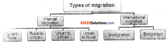
1. Internal Migration :
Movement of people from one region to another within the same country’ is called internal migration. In India there are four streams of internal migration. They are
(a) Rural to Rural
(b) Rural Lo Urban
(e) Urban to Urban
(d) urban to Rural
(a) Rural to Rural: This is estimated that about 65.2% of total migration is of this category’.
Female migrants dominated in this stream. Thus it is an important example for matrimonal migration and it is called women migration.
(b) Rural to Urban : Rural to Urban migration (17.6%) is second important type of migration. Rural – Urban migration is caused by both push of the rural areas as well as pull of the urban areas.
(c) Urban to Urban : Generally, people like to move from small town with less facility to large cities with more facilities.
(d) Urban to Rural : Urban areas are usually affected by the pollution.
The retired and aged people prefer to spend their old age life in nearby villages. Thus people move from Urban to Rural.
2. International Migration : Movement of people from one country to another across international borders is called International migration.
Question 29.
Give an account of land use pattern in India?
Answer:
The important types of land use pattern in India are :
- Forest area
- Land not available for cultivation
- Cultivable wasteland
- Fallow land
- Net area sown.
1. Forest area :
- According to National Forest Policy 1952, reporting area of the forest must be 33.3.% of the total land.
- Madhya Pradesh, Arunachal Pradesh, Odisha, Maharashtra, Andhra Pradesh, Andaman Nicobar. Islands are reporting more area under forests.
- It is due to heacy rainfall and relief features.
2. Land not available for cultivation :
- The land used for human settlements, transport routes, canals, quarries, the mountains, deserts, marshes etc, are coming under this category. It accounts 14.2% of the total land in India.
- Arunachal Pradesh, Rajasthan, Gujarat and Madhya Pradesh, states are having more area under this category.
3. Other Uncultivated lands including fallow land :
This category includes permanent pasture as other grazing area, land under miscellanous tree crops, groves and cultivable waste. This category covers about 8.6% of the country’s total reporting land.
The cultivable waste land is found more in the states of Rajasthan, Madhya Pradesh and Maharashtra.
4. Fallow lands :
- The land which is not used for cultivation for last 3 to 5 years is considered as fallow land.
- It accounts for about 8.13 % of Indias total land.
- The land under this category is reported more in the states of Rajasthan, Andhra Pradesh and Jharkhand.
5. Net area sown :
- India has a net sown area of 46.2% of the total reporting land in India.
- Punjab, Uttar Pradesh, Himachal Pradesh, Jammu and Kashmii, Meghalaya, Nagaland, Mizoram.
Question 30.
Write a note on UKP.
Answer:
This is the biggest Multipurpose project in North Karnataka across the river Krishna.
- it comprises two dams namely Alamatti and Narayanapura.
- The Alamatti dam is constructed near Alamatti village in Basavana Bagewadi taluk and the Narayanapura dam is located near Siddapur village in Muddebihal taluk of Bijapur district.
- The Alamatti dam is 1,578 mt long & its height is 47.8 mt above the lowest foundation level with a gross capacity of 5,285 mcum.
- The Narayanapura dam is 10,637 mt long and 29.7 mt high above the lowest foundation level with a gross capacity of 10,66 mcum.
- It is going to irrigate about 6.22 lakh hectares of land in Bagalkot district, Bijapur district, Yadgir district, Gulbarga district, Raichur district.
- The project also include 6 units of power generation at Alamatti having a total capacity of 268 mw.
Question 31.
Discuss the importance of agriculture in India? –
Answer:
Importance of agriculture in India :
Agriculture is the most important Primary activity and the oldest occupation of human beings in India.
- Main source of livelihood : About 70% of the people directly and indirectly depend on agriculture for their Livelihood.
- Food supply : Agriculture provides food grains, fruits, vegetables, spices etc to the people and fodder for the animals.
- Provides employment facilities : Agriculture is largest sector providing highest employment.
- Source of National income : It contributes to the national income .of the country.
- Source of raw materials for Agro-based-industries ex: Raw cotton, sugar cane and Jute.
- Source of large amount of revenue to the government.
- Support to tertiary sector like transport, communication, banking, insurance etc.
- Help to internal trade like Agricultural products are transported from the area of surplus production to the area scarcity.
- Support to export, many agricutlural products produced in the country are exported i.e. tea, coffee, Jute, Tobacco etc.
- Political & Social situation in the country is determined by the agricultural production
Question 32.
Describe the distribution of wheat cultivation in India?
Answer:
Wheat growing areas can be divided into two:
- Alluvial soilregion – Which includes Uttar Pradesh, Punjab, Haryana, Rajasthan Bihar,
Madhya Pradesh, west Bengal and Uttar Kannada. - Black soilregion – Includes Maharastra, Gujarath, and Western Andhra Pradesh.
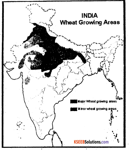
- Uttar Pradesh: It is the largest wheat producing state of India. About 75% area of the state is under wheat cultivation. It is found largely in Ganga – Ghagra and Ganga – Yamuna doabs. Gorakhpur, Meerut, Bulandsher, Jhans: etc.
- Punjab: It is second largest producer of wheat in India. Leading wheat producing districts are L Jalandhar, Ludhiana Bhatinda and Amritsar districts.
- Haryana: It is 3rd largest wheat producing state,and stands 1st in yield per hect of country ie 50.30 quintals per hectare. Kamal, Kurushetra Ambala, paniput, Sonipat are the leading wheat producing areas.
- Madhya Pradesh: It ranks 4th place in wheat production in the country. Sagar, Vidisha, Marena, Gwaliar are important wheat production areas.
- Rajasthan: It is fifth largest producer of wheat in the country. Ganganagar, kota, Jaipur, Ahwar, Tonk and Udaipur are the important produces.
- Bihar: It ranks 6th place in the wheat production. Bhoj pur, Nalanda, patna Begusarai, Saron, and siwan are main wheat growing districts.
- Others: Gujarath, Maharashtra west Bengal, Uttar Khand, Himachal Pradesh, and Karnataka.
![]()
Question 33.
Write a note on Road transport of India?
Answer:
A well known and co-ordinated system of transport plays an important role on trade, transport, social integration and economic development of the country. Importance:- * roads play a vital role in transporting the passengers for a short and Medium distances. * It is capable of providing door to door service * the perishable goods like vegetables, fruits, and milk can be transported easily by road ways. * Road – transport helps the industry by moving raw materials to industries and finished goods to market. * it provides employment opportunities. * The road traffic accounts for 85% of passengers and 65% of goods traffic by the end of length plan. * It plays a vital role in national and International security. * In hilly area, roads are only the means of effective transport. * Lastly roads are especially useful for defence, purpose, particularly in border areas.
Question 34.
Explain the causes and problems of Slums?
Answer:
- Slums are in environmentally unsuited and degraded area. Houses in slums are decaying, poor hygienic conditions, poor ventilation.
- Lack of basic amentities like drinking water, light and toilet facilities.
- They are overcrowded having narrow street pattern prone to serious hazards from fire.
- People living in slums are poor. Therefore problems are common.
- They arc the undernourished, prone to different types of diseases and illness.
- They can not afford to give proper education to their childern.
- The Poverty makes them valnerable to drug abuse alcoholism, critic, vandalism and ultimately they face social exclusion.
Causes for the slums:
City characterized by substandard housing and dirt
- Most are inhabited by poor people lacking reliable sanitation.
- Scarcity of clean water reliable electricity, timely law enforcement and other basic services.
- Slum residences are poorly built, deteriorated building.
Section – D
IV. Answer any one of the following: ( 10 × 1 = 10 )
Question 35.
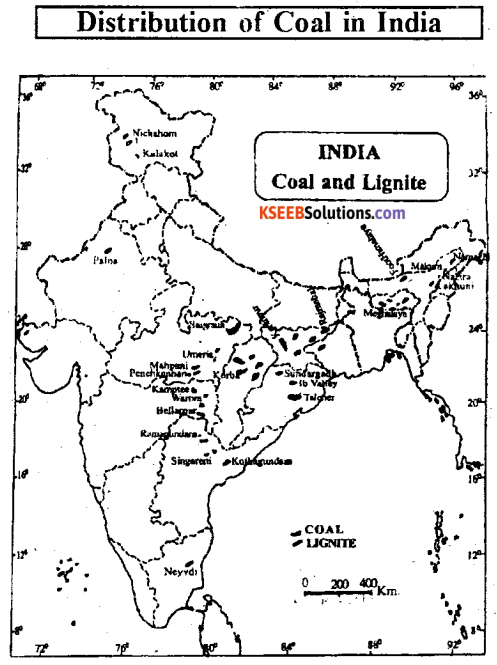
Discuss the distribution of coal in India? 1
Answer:
Importance :
- Coal constitutes about 70 percent of the total commercial power consumed in India.
- Coal is a source of energy and raw material for many chemical industries.
- It provides many by products i.e., tar napthaline, ammonia gas, coal gas, benezol etc.
- These are used in the manufacture of synthetic fibres, rubber, plastic, explosives, dyes and insecticides.
Distribution :
- Currently the leading producer of coal in India are Jharkhand, Chhattisgarh, Odisha and
- Madhya Pradesh.
- These four states contributes 84.33 per¬cent of the India’s coal production.
1. Chhattisgarh : It is having first place in the production of coal in India.
- It produces 31.3 percent coal of India.
- Major coal fields of the state are located in the Northern part of the state i.e, Surgija, Bilasapur and Korba.
2. Jharkhand : Jharkhand is the second larg¬est producer of coal in India.
- It produces more than 20.3 percent of coal in 2011-2012.
- Jharia, Bokaro, Giridhi, Karnapur, Ramagarh are very important.
- Jharia is one of the oldest and richest coal fields of India. It has been recognised as the “Store house of the best metallurgical coal” in the country.
3. Odisha : It is the third largest producer of the coal and contributing 19.5 percent of the total coal production of the country .
- Most of its coal deposits in Dhenkanal, Sambalapur and Sundaragh districts.
4. Madhya Pradesh : Jharkhand is the second largest producer of coal in India.
- The main coal depoists are located in Sindhi, Shahdol, Betul, Narasingour and Chhindwara districts.
5. Andhra Pradesh :
- It produces about 9.7 percent of coal.
- It is found in Adilabad, Karimnagar, Warangal districts. ‘
6. Maharashtra : The coal deposits of the state occur in Wardha valley, Ballarpur, Warora in Chandrapur district.
7. West Bengal :
- It has 4.48 percent of the total production of the country.
- Burdwan, Bankura, Purulia, Daijeeling and Jalpaiguri are the chief coal producing districts.
Production :
The total reserves of all grade coal in India is 283.50 billion tonnes.
- India is producing 560.90 million tonnes of coal in 2012-13.
- So India ranks third among the coal producing countries of the world next to China and USA.
- It contributes 10.2 percent of the total world’s production of coal.
![]()
Question 36.
Explain the development and distribution of Iron and steel industry in India?
Answer:
Importance:
- The Iron and Steel industry is described as a basic Industry.
- Iron and Steel supplied by this industry such as machineries, irrigation projects, ship build¬ing, power projects, construction of bridges, buildings, transport equipment, machine tools and so on.
- The Production and Consumption of Iron and Steel is an index level of the economic develpoment of a country.
Distribution:
There are nine major Iron and Steel industries in India.
- Tata Iron and Steel Company (TISCO), Jamshedpur :- It was established in 1907. It was the first largest steel plant of the country.
- Vishveswariah Iron and Steel Co. Ltd (VISL) Bhadravathi 11 was first estab¬lished in 1923 by the princely state of Mysore located at Bhadravathi in Shimoga district of Karnataka.
- India Iron and Steel Company Ltd (IISCO) Bunpur:- It was established in 1919 at Bumpur in West Bengal. It was the second largest integrated steel plant after Tata Iron and Steel Ltd.
- Hindustan Steel Company Ltd,
- Rourkela :- It was completed with the German collaboration. The steel plant was comminssioned in 1955.
- Bhilai Steel Plant :- It has the largest steel production plant of the public sector. It is located at Bilai near Raipur in Chhatisgarh.
- Durgapur Steel Plant :- The steel plant in Durgapur in West Bengal was established with British collaboration and was commissioned in 1956.
- Salem Steel Plant:- It is located at Salem in TamilNadu and the production was started from 1982.
- Vishakapatnam Steel Plant :- Established by National Ispat Nigam Ltd in Andhra Pradesh.
- New Steel Plants Some private sectors plants are.
- Jindal Vijaynagar Steel Ltd (JVSL):- This steel plant is located at Tomagal, Bellary district in Karnataka.
- Essar Steel Ltd (ESL):- It is situated at Hazira in Gujarat.
- Ispat Insutries Ltd (IIL):- It is situated at Dovi, Ratnagiri district of Maharashtra.
- Neelachal Ispat Nigam Ltd (NINL) :- It is a new steel plant located at Dubai, Odisha.
- Mini Steel Plants :- Presently, 199 lincensed electric ore furnace units with an installed capacity of 7.8 million tonnes have been commissioned and hence started commercial production.
Section – E
V. Answer any two of the following: ( 10 × 2 = 20 )
Question 37.
Represent the following data by a pie-chart?
India: Area under selected kharif crops (in lakh hectare)
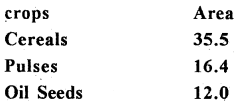
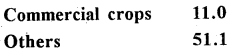
Answer:
| Crops | Area |
| Cereals | 35 |
| Pulses | 16.4 |
| Oil seeds | 12.0 |
| Commercial crops | 11.0 |
| Others | 5.1 |
![]()
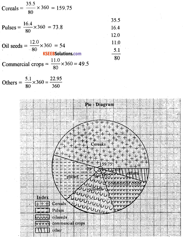
Question 38.
Construct a line graph to represent the following data.
Karnataka ; Selected districts wise area under rice [in hectares]
Answer:
| District | Area |
| Bellary | 1,22,72 1 |
| Davanagere | 1,30,208 |
| Mysore | 1,23,803 |
| Raichur | 1,64,925 |
| Shimoga | 1,31,070 |
| Mandya | 88,657 |

Question 39.
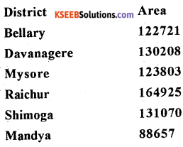
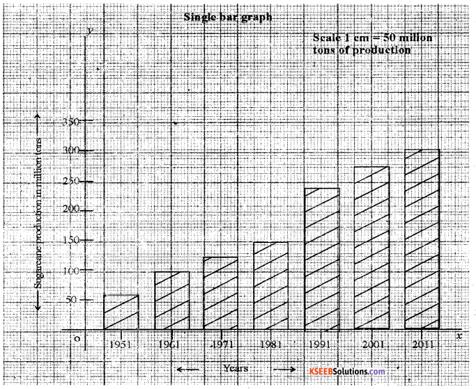
Represent the following data by means of vertical bar graph.
India : Decade – wise sugarcane production (in million tons)
| Year | Production |
| 1951 | 57.05 |
| 1961 | 110.0 |
| 1971 | 126.36 |
| 1981 | 156.24 |
| 1991 | 241.04 |
| 2001 | 286.00 |
| 2011 | 310.0 |
39. Answer any two questions of the following
(a) Distinguish between primary and secondary data.
Answer:
| Primary | secondary |
| (a) The data which are collected for the
first time by a researcher or group of researchers, institutions or organizations are called Primary data. |
(a) The data those have been collected and
analyzed already by some departments, NGO’s etc …. are called Secondary data, |
| (b) These are original in character and first
hand information. |
(b) Here instead collecting the data by primary
method the researcher may take, the help of secondary data. |
(b) Explain the components of GIS.
Answer:
The components of GIS are
- Data : Geographical data can jbe divided into 3
- Spatial data Any data which is associated with a specific geographical location, eg Locating of India, Bangalore city, KRS dam.
- Attribute/Non-spatial data Any data which is not associated with a specific geographical location.
- Continous dataThe data which have no discrete boundaries like soil, atmospheric temperature and land elevation.
- Software : There are the programmes designed to run the computer. However, GIS is designed to collect, store, process geographical data and construct maps.
- Hardware : Hardware comprises storing and processing devices like central process unit, monitor}’, key board, mouse, printer, scanner etc …
- People : This component consists of the skilled people who involve in data capturing, ‘, processing and analysing.
- Analysis : It involves the processing of GIS data with various analyses so as to get meaningful information.
(c) Explain the three segments of GPS.
Answer:
There are three segments of GPS:-
1. The space segments : The satellites of GPS are launched and positioned at an altitude of approximately 20200 km which is almost more than three times of the earth’s radius. The space segment consists of a constellation of 24 functioning GPs satellites located in 6 orbital plane with 4 satellites in each orbital plane. The time for the satellite to complete
one revolution around the earth is 11 hrs and 58 minutes.
2. The control segment: The control segment consists of facilities necessary for satellites especially healthy monitoring, telemetry, tracking command and control clock error ‘ computation .of satellites. There are 5 GPS stations spread over the earths surface they are –
- Hawaii
- Colorado spring
- Ascension Island
- Diego Garcia
- Kwajalein.