Karnataka 1st PUC Geography Question Bank Chapter 9 Physiography
You can Download Chapter 9 Physiography Questions and Answers, Notes, 1st PUC Geography Question Bank with Answers Karnataka State Board Solutions help you to revise complete Syllabus and score more marks in your examinations.
1st PUC Geography Physiography One Mark Questions and Answers
Question 1.
What is the other name to the Himalayas?
Answer:
The Himalayas means‘abode of snow’. Or Young fold mountains’.
Question 2.
Which mountain range is called ‘backbone of Asia’?
Answer:
Karakorum range is called backbone of Asia.
Question 3.
Name the longest and the largest glacier of India.
Answer:
Siachen (70Km) is the longest and largest glacier of India.
Question 4.
What is the other name to Outer Himalayas?
Answer:
Siwahk are called as outer Himalayas.
![]()
Question 5.
Name the largest Doon of India.
Answer:
Dehradun is largest Dun of India.
Question 6.
In which regional Himalayas Jclep la pass is found?
Answer:
The Central or Sikkim Himalayas.
Question 7.
What is Terai plain?
Answer:
It is a marshy land wide spread in the regions of excess dampness, thick forests, rich wild life etc. It is found to the south of Bhabar with wide marshy tract, where streams reappear to the surface.
![]()
Question 8.
Mention the highest peak of Peninsular plateau.
Answer:
The highest peak of Peninsular plateau is Anaimudi (2695m) situated in Annamalai hills of Kerala.
Question 9.
Which region of India is called ‘Ruhr of India’?
Answer:
The Chotanagpur plateau is called‘Ruhr of India’.
Question 10.
Where do Western Ghats and Eastern Ghats meet?
Answer:
The Western Ghats and Eastern Ghats meet in Nilgiri Hills
![]()
Question 11.
Name the longest coastal plains of India.
Answer:
The longest coastal plains of India from Gujarath (Rann of Kutch) in the west to West Bengal In the east, (61 OOKm)
Question 12.
State the location of the Great Indian Desert.
Answer:
The Great Indian Desert is located at the Western part of the Aravali Range.
![]()
Question 13.
Name one important river of the Great Indian Desert.
Answer:
The Luni is the important river among of the Great Indian Desert.
Question 14.
Name the Salt water lake in the Thar Desert.
Answer:
Sambhar Lake is the salt water lake in the Thar Desert.
Question 15.
Name the plateau which lies between the Western and Eastern Ghats of South India.
Answer:
The Deccan plateau lies between the Western and Eastern Ghats of South India.
![]()
Question 16.
Which is the highest peak of India?
Answer:
K2 or Mount Godwin (8611m) is the highest peak of India or Second highest peak of the world.
Question 17.
Which is the highest mountain peak in South India?
Answer:
Anai Mudi (2,695m) in Annamalai hills of Kerala is the highest peak in south India.
![]()
Question 18.
Which is the oldest and largest physiographical division of India?
Answer:
The peninsular plateau (16 lakh sq.km) is the oldest and largest physical division of India.
Question 19.
Which is the highest peak of Eastern Ghats?
Answer:
Mahendragiri in Orissa (1501m.) is the highest peak of Eastern Ghats.
Question 20.
Which island of India is formed with the volcanic activities?
Answer:
The Andaman and Nicobar Islands are formed with volcanic activities.
![]()
Question 21.
Which island of India is formed by Corals?
Answer:
The Lakshadweep islands are formed by corals.
Question 22.
Why are the Himalayan Rivers perennial?
Answer:
Most of the Himalayan Rivers originate from the glaciers and they get water from the rainfall as well as from the glaciers.
![]()
Question 23.
From which mountain pass does the river Sutlej enter India?
Answer:
Shipki-la-pass the river Sutlej enters to India.
Question 24.
Which is the longest and the largest tributary of Ganga?
Answer:
The Yamuna is the longest (1380) and largest tributary of the Ganga.
![]()
Question 25.
Which is the largest and longest river of South India?
Answer:
Godavari is the longest (1465km) and largest river of South India
Question 26.
What is Do-ab-region?
Answer:
The region or plain lying between two rivers. Ex: Ganga and Yamuna river is called as Do-ab region.
Question 27.
Which river makes Kapiladhara water fall?
Answer:
Narmada river.
![]()
Question 28.
Which river is called Dakishina Ganga?
Answer:
Kaveri (Cauvery-805 Km)
Question 29.
Which is the Asia’s First hydroelectricity generated station?
Answer:
The first hydro electric project of Asia was started on the river Kaveri in 1902atShivanasamudra (Shimsa).
![]()
Question 30.
Where do river Tungabhadra and Krishna meet?
Answer:
The Tufigabhadra and Krishna meets at Alampur near Kurnool in Andhra Pradesh.
Question 31.
Mention the major stream of river Ganga.
Answer:
The two major streams are Alakananda and Bhagirathi.
![]()
Question 32.
What is Hydel Power?
Answer:
The power generated from water is called the hydel power.
Question 33.
Which rives of India flow in rift valleys?
Answer:
Narmada and Tapi.
Question 34.
Which river is called ‘Sorrow river of Orissa’?
Answer:
Mahanadi river is called‘sarrow river of Orissa’.
![]()
Question 35.
What is a Lake?
Answer:
A water body, completely surrounded by land is known as a lake.
Question 36.
Name some important fresh water lakes of India.
Answer:
Dal Lake, Bhimtal, Nainiral, Loktak and barapani.
Question 37.
Why do many peninsular rivers have straight and linear courses?
Answer:
Because of hard rock bed and lack of silt and sand in their courses. They do not form meanders.
![]()
Question 38.
Which city is located on the water divide between the Indus and Ganga river systems?
Answer:
Amritsar located on the water divide between the Indus and Ganga river systems.
Question 39.
Which place is the confluence of rivers Alkananda and Bhagirathi?
Answer:
Devaprayag.
![]()
Question 40.
Which is the largest freshwater lake in India?
Answer:
Wulur lake is the largest freshwater lake in India.
Question 41.
Which river is called ‘sorrow river of West Bengal’?
Answer:
Damodar River is called Sorrow of West Bengal.
Question 42.
Which river is called ‘National River’?
Answer:
Ganga River is called National River.
![]()
1st PUC Geography Physiography Two Mark Questions And Answers
Question 1.
Name any four tributaries of river Indus.
Answer:
The Sutlej, Ravi, Jhelum, Chenab and the Beas are the major tributaries of Indus river.
Question 2.
Mention any four west flowing rivers of Peninsular India.
Answer:
The Luni, Sabarmati, Tapi, Kali, Sharavathi, Netravati, Peryiar are the major west flowing rivers.
Question 3.
What are the salient features of River regime?
Answer:
The pattern of the seasonal flow of water in a river is called its regime. It is the variability in its discharge throughout the course of a year in response to precipitation, temperature and drainage basin characteristics. The pattern of flow of water in the Himalayan river is different fro the peninsular river due to difference in climate. The Himalayan Rivers are perennial and the regime of the peninsular rivers is seasonal as they are dependent on monsoon rains.
![]()
Question 4.
What is the necessity of Inter-linking of Rivers?
Answer:
The distribution of rainfall in India is highly uneven and seasonal. The Himalayan rivers are perennial while the peninsular rivers are seasonal. During rainy season, much of the water is lost in floods and wasteful flow into the sea. But in other seasons there is scarcity of water. Even in India some parts gets more rainfall and some other parts get very low rainfall. The problems of floods and drought can be minimized through the inter-river linkages or through national water grid, under which water from one river basin can be transferred to another river basin for optimum utilization. ’
Question 5.
Mention the back water lakes of East Coast of India.
Answer:
Pulicat Lake (TN), Kolleru (AP) Chilka (Orissa) are the important back water lakes of India.
Question 6.
What are riverine islands?
Answer:
In the lower course of the river, due to gentle slope, the velocity of the river decreases and it involves into depositional work leading to the formation of rivierine islands. For example, Majuli in the Brahmaputra.
Question 7.
Mention any two ranges of Trans Himalayas.
Answer:
Karakoram range, Ladakh range and Zaskar range.
![]()
Question 8.
Mention any two hill stations of the Himalaya
Answer:
The important hills stations are Shimla, Mussorie, Raniket, Nainital, Almora, Chakrata, Darjeling etc.
Question 9.
Distinguish between Bhangar and Khadar plains.
Answer:
Bhangar Plains: It is an Old Alluvium. It contains the Kankar nodules with calcium carbonates and it is less fertile.
Khadar Plains: It is a new alluvium. It does not contain the kankar nodules and it is very fertile.
Question 10.
Name any two Ghats of the Western Ghats.
Answer:
Thalghat, Bhjorghat, Palghat, Agumbe ghat, Shiradighat, Charmadighat are the major Ghats of the Western Ghats.
Question 11.
Which coastal plains are found in Karnataka and Tamil Nadu?
Answer:
The Malabar Coast extends from Mangalore to Kanyakumari, Sand dunes, lagoons and backwaters are the important features of this coast.
![]()
Question 12.
State the difference between Lakshadweep and Andaman and Nicobar islands.
Answer:
Lakshadweep Islands: These islands are located to close to the Malabar Coast of Kerala. These are composed of small coral islands. They are small in size as compared to the Andaman and Nicobar islands.
Andaman and Nicobar islands: These are located in the Bay of Bengal. These are bigger in size and are more numerous and scattered. These are islands are an elevated portion of the submarine mountains.
Question 13.
What is ‘Duns’? Mention with examples.
Answer:
In the Siwaliks many flat bottomed valleys are there, they are known as duns. The important duns are Dehradun, Kotadun, and Patili, Chaukambadun in Uttaranchal and Udampur and Kotli in Jammu and Kashmir.
Question 14.
Mention the regional divisions of Himalayas
Answer:
The major regional divisions of Himalayas are:
- Punjab Himalayas (Sindhu-Sutlej)
- Kumaon Himalayas (Sutlej-Kali)
- Nepal Himalayas (Kali-Tista)
- Assam Himalayas (Tista-Brahmaputra)
![]()
Question 15.
Mention the Central Plateaus of India?
Answer:
The central plateaus are Malwa plateau, Bundhel Khand plateau, Bhagelkhand, ChotaNagpur and Ranchi plateau.
Question 16.
Which are the important valleys passes in Himalayas?
Answer:
Zojila and Burzil in Kashmir, Shipkila and Bralapcha la in Himachal Pradesh. Thang la, niti and lipu lekh in uttarPradesh,jelep laandNiithu lain Sikkim.
Question 17.
Write any four characteristics of the Indian desert.
Answer:
- It lies towards the western margins of the Aravalli hills.
- It is an undulating sandy plain covered with sand dunes.
- This region receives very low rainfall below 150mm per year.
- It has arid climate with a low vegetation cover.
- Streams appear during the rainy season.
- Luni is the only river in this region
- The Barchans cover larger areas but longitudinal dunes become more prominent near the Indo-Pakistan border.
1st PUC Geography Physiography Five Mark Questions And Answers
Question 1.
Name the important physical divisions of India. Explain the Himalayas.
Answer:
India is characterized by great diversity in its physical features. On the basis of physiography, the country is divided in to four major physical divisions. They are:
- The Northern Mountains
- The Northern Plains
- The Peninsular Plateau
- The Coastal Plains and Islands
The Himalayas: This is loftiest and snow covered mountains in the world. The area occupied by the Himalayas was earlier a part of ‘Tethys Sea’. The formation of this mountain is by tectonic forces of Gondawana land Angara land masses. It is situated to the north of the Indus and Ganga and the Brahmaputra plains.. The slopes of the Himalayas are gentle towards the north and steep towards south.
The Himalayas have distinct characteristics of high relief, snow covered peaks, complex geographical structures, parallel separated by deep valleys and rich temperate vegetation.The Himalayas are classified into three parallel ranges based on altitude and latitude.
The Great Himalayas or Himadri The lesser Himalayas or Himachal The Outer Himalayas or Siwaliks.
a. The Great Himalayas or Himadri: These are the inner most loftiest and continuous ranges of mountains. The average height of the Great Himalayas is 6200 m and the width varies between 120 and 190 km. The important peaks of great Himalayas in India are, Kanchenjunga-8598m in Sikkim, Nanga Prabat-8126m, Nandadevi, Badrinath, Karmet, Trishuletc.
b. The lesser Himalayas or Himachal: These ranges are also known as Inner Himalayas or Himachal ranges. It is situated between great Himalayas inn the north and Outer Himalayas or Siwaliks in the south. Its average height is around 1500-4500m and the width is about 60 to 80 km. These are very rugged and complex ranges due to erosion by rivers. The important ranges in Lesser Himalayas are Pirpanjal, Dhaul Dhar and nag- tiba etc. The important Hill stations are Shimla, Musooire, Ranikeht, Nainital, Almora, Chakrata, Darjeeling etc. Kulu valley, Kangra valley, Spiti valley are the famous valleys of Himachal.
c. The Outer Himalayas or Siwaliks: These are the outer most ranges situated to the south of Lesser Himalayas, known as Siwaliks. The Siwaliks extend from Jammu & Kashmir in the North West to Arunachal Pradesh in east. The average height of this range is around 600-1500m and its width varies between 15-5Qklm. The siwaliks are formed from the sediments brought down by the rivers of lesser, and Greater Himalayas.
There are flat floored structure valleys between Siwaliks and Lesser Himalayas, Known as Siwaliks. The Siwaliks extend from Jammu&Kashmir in the North West to Arunchal Pradesh in east.
![]()
Question 2.
Briefly explain the Regional Himalayas.
Answer:
The Himalayas are also classified into Regional and Longitudinal divisions. They are:
The Kashmir Himalayas The Himachal Himalayas The Kumaun Himalayas The Central or Sikkim Himalayas The Eastern Himalayas.
a. The Kashmir Himalayas: They are spread over in Jammu and Kashmir for about 700sqkm. The important parallel ranges in the Kashmir Himalaya are Karakoram, Ladak, Zaskar and Pirpanjal. They are characterized by high snow covered peaks, largest number of glaciers, deep valleys and High Mountain passes. The north-eastern part of the Kashmir Himalayas is a cold region and it lies between the Grater Himalayas and the Karakorum ranges. A special feature of the Kashmir valley is the Karewas. The important mountain passes are Banihal, zoji-la, Chang-la, Khardung-la etc.
b. The Himachal Himalayas: It is found in Himachal Pradesh and parts of Punjab, comprising of all the three ranges. The beautiful valleys of Kullu, Kangra, Lahul and Spiti known for orchards and scenic beauty are found here. Shipkila, Rohtang, bara- lacha la are the famous mountain passes and Kullu manali, shimla, Dalhousie, Chama etc.
c. The Kumaun Himalayas: This section extends from Sutlej to kali river valleys and has distance of320kms. The pilgrimage centers like Badrinath and Gangothri are located in this section of Himalayas.
d. The Central or Sikkim Himalayas: This section extends from kali to Tista and has a distance of about 800kms. It is also called as Nepal Himalaya. Mount Everest is located in this 3sectino of Himalaya. This section is further divided for the study into Sikkim, Darjeeling and Bhutan Himalayas.
e. The Eastern Himalayas: This range extends from Tista to Brahmaputra valley covering the states of Assam and Arunachal Pradesh. The width is about 730 kms Naga and Patkaibhum hills are located in this section. This region is very important for tea cultivation.
![]()
Question 3.
Describe the significance of Northern Plains.
Answer:
- The Northern Plain plays a very significant role in the life of the people and economy of the country.
- The Northern plains have high concentration of population 45% of India’s population.
- They are helpful for agro-based industries and urbanization.
- The northern plains have fertile soil, uniform surface and perennial rivers-suitable for agriculture.
- The plains have encouraged the development of transport and communication.
- The rivers in the plain help in the development of inland water transportation.
- It has rich underground water, useful for irrigation and other activities.
- It has cultural and traditional importance.
- They have great social, religious and political significance.
![]()
Question 4.
Peninsular Plateau is the largest physical divisions of India. Explain its features.
Answer:
The Peninsular Plateau is the largest and oldest physiographic division of India. It lies to the south of the Northern Great Plains and covers and area of about 161akh sq km. The elevation of this upland varies from 600 to 90m. This is in inverted triangle shape, with wide base lying in the north and the apex formed in the south, with tilt towards south eat.
It is bounded by the Aravallis in the North West, Bundelkhand plateau in the north, Rajmahal hills in the north east, the Western Ghats in the west and the Eastern Ghats in the east. The highest peak of Peninsular plateau is Anaimudi (2695 m) situated in Annamali hills of Kerala.
On the basis of relief features the peninsular plateau is divided into two main divisions. They are, The Central high lands: This is a smaller region of peninsular plateau situated to the north of the Narmada river. It is slightly tilted towards north. It include the Aravallies, the Malwa plateau, the Vindhya range, the Bundelkhand, the Baghelkhand and Chotanagpur plateau and Rajmahal hills.
The Aravallies runs from north east to south west for about 8900 km between Delhi to Gujarat. It is one of the oldest folded mountains of the world. Its highest peak is Guru Shikar (1722m). It separates Rajasthan- upland and agricultural region. The Aravallis are composed of quatizetes, gneisses and schists.
Rivers like the Luni, Sabarmati and the mahi flow from Aravalli ranges. The Malwa plateau is bordered by the Aravallis in the north and the vindyan range in the south. This plateau has to drainage systems i) Narmada and Mahi towards the Arabian Sea ii) Chambal, Sind, Betwa and Ken towards the Bay of Bengal. ’
The vindyan range extends in ease west direction for about 1050km. The kaimur hills lies in the east of Vindhya range and the Maikala range forms a link between the Vindhya and Satpura ranges.
The Deccan Plateau: this is a triangular plateau situated to the south of the river Tapi or Tapti. The Deccan trap is the crystalline core of the lava effusions forming this plateau are believed to have occurred through a fissure volcano and this region is considered a lava shield. It occupies the areas of Maharashtra, Karnataka, Andhra Pradesh and parts of Chhattisgarh, Odisha and Tamil Nadu.
Eastern Ghats: They form eastern boundary of the Deccan Plateau. They are “separated by the river valleys. The Eastern Ghats stretch to 800 km from Mahanadi valley in the north to Nilgiri hills in the south. Its average height is around 600m.Nallamalla, Kallamalai, B.R.Hills and M.M.Hilis are the important hills of Eastern Ghats.
The important peaks are Aramakonda, Singaraju, Nimalgiri, Mahendra giri etc. Aramakonda is considered as the highest peak of the Eastern Ghats. These zones are rich in Iron ore, Manganese ore, Limestone, Coal, Mica etc.
Western Ghats: It is also known as Sahyadris. They are almost continuous mountain system running parallel to west coast for about 1600km., from north-west to south direction. The Western Ghats meet the Eastern Ghats in Nilgiri hills.
The Western Ghats form a watershed of the peninsular rivers. Important rivers like the Godavari, Krishna, Kaveri, Sharavati, Periyar etc, rise in this zone. They are sources of hydro¬electricity. They are covered with dense evergreen and monsoon forest and rich bio-diversity zones.
![]()
Question 5.
Briefly explain the Coastal plains of India.
Answer:
This is the region all along the Indian coastline, lying between the coast and the mountain ranges of the peninsular plateau. India has 6100 km from Gujarat in the west to West Bengal in the east. The average width is 10-25 kms. The coastal plain of India is divided into two parts.
The West Coastal plains: It is extends between the Arabian Sea and the Western Ghats. It is narrower than the east coastal plains, stretching to a length of about 1400km and width of 10 to 80km from the Rann of katchchh to Kanyakumari. The west coastal plains have Gujarat, Konkan, Karnataka and Malabar Coasts.
The Gujarat Coast comprises of Rann of Kachchh and Cambay coasts. It is formed by the alluvial deposits of Sabarmati, Mahi, Luni and other small streams. Gujarat has the longest coastline in India Kandla and okha are famous sea ports and along is the biggest ship breaking center. It produces highest salt in the country.
Konkan Coast lies to the south of Gujarat coast and extends line which provides suitable site for natural seaports. Eg: Mumbai, Navasheva, Marmagoa, Karwar, New Mangalore etc., this coast records highest coastal erosion. It is very rich in Petroleum and natural gas. Karnataka coast: it is a part of Konkan coast.
It extends from karwar in the north to Mangalore in the south. It is the narrowest part of west coastal plains. Karwar and New Mangalore are important ports in this belt. Sea Bird, the naval base near Karwar is the largest naval base in India.
The Malabar Coast extends from Mangalore to Kanyakumari, Sand dunes, lagoons and backwaters are the important features of this coast. Cochin or Kochi is the biggest seaport in this coast. Backwaters of Kerala facilitate navigation and tourists enjoy traveling though small country boats. The first south west monsoon rainfall is received in this coast.
East coastal Plains: It lies between the Ea’stern Ghats and the Bay of Bengal stretching from the delta of Hooghly in the North to Kanyakumari in the south. Compared to the west coastal plains the east coastal plains are broader.
The Tatkal Coast: It is the coastal plain of Orissa state. It extend for about 400kmms, north from Subarnarekha river to south of the Rushikulya river. It has a chilka lake, which is the largest salt water lake in India, Para deep is the important horbour located here.
Coromandel Coast: The southern part of east coast is known as the Coromandel Coast. It gets more rainfall from the north east monsoons and it is highly affected by cyclones. The oldest harbor Chennai located here.
![]()
Question 6.
Describe the important features of Islands and Indian desert.
Answer:
India has a total of 247 islands. Ofthese204 are in the Bay of Bengal and the remaining 43are in the Arabian Sea. The islands of the Bay of Bengal are called Andaman and Nicobar islands, which are largely tectonic and volcanic in origin. In Andaman there are four groups of islands – North Andaman, Middle Andaman, South Andaman and Little Andaman, Port Blair the capital of Andaman and Nicobar Group Island is situated in South Andaman islands. Barren and Narcondam are famous volcanic islands in this group.
Nicobar are three groups of islands – Car Nicobar, Little Nicobar and Great Nicobar. The Andaman and Nicobar islands have warm tropical climate and receive heavy rainfall during monsoon seasons and they have thick forest and rich wildlife.
The islands of the Arabian Sea are called Lakshadweep Islands. These islands are very close top Kerala. These are coral in origin and are surrounded by fringing reefs. Kavarati is the capital of Lakshadweep islands. Minicoy and Amnidivi are the important groups in Lakshadweep.
Indian Desert: It lies to the west of the Aravallis. This desert is formed by the work of wind and climatic extremities. The total area of the desert is around 1, 75,000 sq.km. Rajasthan, parts of Gujarat, Punjab and Haryana come under Thar Desert.
The desert proper or central region of the desert is called ‘Marustali’. The atmospheric condition I the desert is extreme. During summer temperature exceeds 50° C and in winter it comes down to 10° C and below. Ganganagar of Rajasthan has recorded more than 54° C of temperature. The rainfall in the desert is very low. Roylee, a place in North Rajasthan, recorded the lowest rainfall in the country (8cm per year). Indian desert comprises mainly of sand dunes. There are a few salt lakes in the desert like Sambhar, Tal, Katu and it has thin vegetation.
![]()
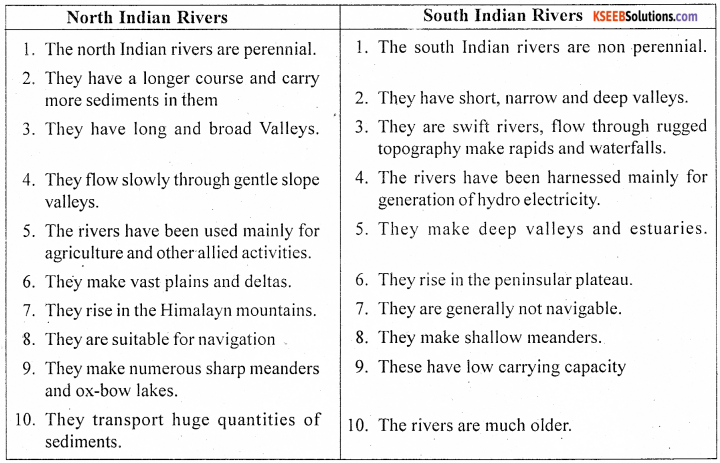
Question 7.
Compare the North Indian rivers with South Indian Rivers.
Answer:
Question 8.
Why does River water dispute arise? Mention the important disputes and proposed measures.
Answer:
Water dispute means any dispute or difference between two or more state governments with respect to the use, distribution or control of the waters of, or in, any inter State River or river valley. Water, being the most precious resource is required for domestic, irrigation and industrial purposes. Most of the Indian rivers flow across more than one state. Each of the state of the river tries to obtain the maximum quantity of water. This has resulted in many water disputes in the country.
Some of the important inter state water disputes water disputes in India are:
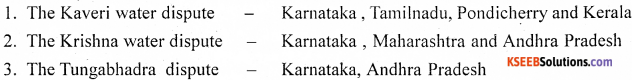
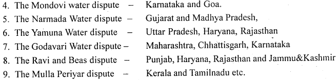
International water disputes:
In the recent years the rivers flowing across more than two countries are also creating trouble between the neighbouring countries. At present river water dispute has become a global phenomenon. In the developing countries like India the inter-state dispute must be resolved quickly so that water resources could be utilized and harnesses properly for basic need and economic development. One of the measures could be to declare all the major rivers as national property and national schemes under Central assistance should be launched for the development of total command area of the concerned states.
Interlinking of Rivers are played a significant role to solve the water dispute. The distribution of rainfall in India is highly uneven and seasonal. The problems of floods and drought can be minimized through the inter-river linkages or through national water grid, under which water from one river basin can be transferred to another river basin for optimum utilization.
The important inter-linking projects proposed are:
- The Ganga-Kaveri link canal connecting the basins of the son, Narmada, Tapti, Godavari, Krishna and Pennar.
- The Brahmaputra- Ganga link canal passing through Bangladesh.
- The Narmada canal passing through Gujarat and Rajasthan.
- The link canals between the rivers of the Western Ghats towards the east.
- The canal from the Chambal to central Rajasthan.
![]()
Question 9.
Briefly explain the importance of Inter-linking of Rivers in India.
Answer:
The distribution of rainfall in India is highly uneven and seasonal. The Himalayan rivers are perennial while the peninsular rivers are seasonal. During rainy season, much of the water is lost in floods and wasteful flow into the sea. But in other seasons there is scarcity of water.
Even in India some parts get more rainfall and some other parts get very low rainfall. Consequently there are floods in one region and drought and famine in other regions in the country. The problems of floods and drought can be minimized through the inter-river linkages or through national water grid, under which water from one river basin can be transferred to another river basin for optimum utilization.
The inter-link would consist of two parts, a northern Himalayan River Development component and a southern peninsular river development component. The northern component would consist of series of dams built along the Ganga and Brahmaputra rivers in India, for the purposes of storage, canals would be built to transfer surplus water from the astern tributaries of the Ganga to the west. The Brahmaputra and its tributaries would be linked with the Ganga and the Ganga with the Mahanadi river. This part of the project would provide additional irrigation and generate electricity.
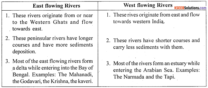
Question 10.
Differentiate between East flowing rivers and West flowing rivers.
Answer:
![]()
1st PUC Geography Physiography Ten Mark Questions And Answers
Question 1.
Explain the river system of India with suitable maps. (T.B.Qn)
Answer:
On the basis of origin and flow the river system of India can be broadly divided into two groups. They are.
- The Himalayan Rivers or North Indian Rivers
- The Peninsular Rivers or South Indian rivers.
A. The Himalayan Rivers: These rivers take birth in Himalayan Mountains by glaciers and flows throughout the year (perennial). There are three main river systems in the Himalayan rivers. They are the Indus, the Ganga and the Brahmaputra.
1. The Indus river system: The Indus is one of the most important river systems of India. It rises near Mt. Kailash (6714m), has a length of 2880km, of which 709 km lies in India. It flows through narrow gorges between Ladakh and Zaskar ranges in the North West direction in Jammu & Kashmir. It is one of the oldest river systems of the world. Major part of its course and catchment area are in Pakistan. The main tributaries are Jhelum, Chenab, Ravi, Beas and Sutluj.
2. The Ganga: The Ganga is the longest (2500Km) and the largest river system of the country. It is generally called, the ‘National river’ of India. The Ganga has two head streams-the Bhagirathi and the Alakananda. The Bhagirathi takes it is birth in Gangothri and Alakananda rises near Badrinath in Garhwal Himalayas. These two meet at Devaprayag, and continue to flow as the Ganga, after flowing across the Himalayas; the Ganga enters the Great Plains at haridwar. From Haridwar it flows towards south an south east up to Mirzapur.
It continues to flow eastwards in the Gangetic plains of Bihar and West Bengal and enters Bangladesh, where it joins the Brahmaputra and become padma, and finally flows into Bay of Bengal. The important tributaries of Ganga are Ramganga, Ghagra, Gandak, Gomati, Bagmati, Kosi, Yamuna, Chambal, Betwa, sone, ken, damodar etc.
3. The Brahmaputra river system: It rises at Manasarovar lake (chanmyandung). In Tibet it is known as Tsangpo. It enters Aruncal Pradesh and is known as Brahmaputra. It joins Ganga at Golunde (Bangladesh). The total length it flows is 2900km. and only 885km. in India. In Bangladesh it is called Meghana.
B. Peninsular Rivers: The peninsular plateau of India has the largest network of river systems in the country. Most of the south Indian rivers rise in the Western Ghats and central highland regions. On the basis of the direction of flow the rivers are grouped into two types.
- The East flowing rivers.
- The west flowing rivers.
B. 1 The East flowing rivers: These rivers rise in Peninsular region, flow in eastern direction and Finally join the Bay of Bengal. The important east flowing rivers are:
The Mahanadi: It rises in sihawa or simhava region of Chattisharh and is the most important river of Odisha and Chattishgarh. The river flows to a length of 885 km and joins the Bay of Bengal ear Cuttack. The main tributaries of Mahanadi are Seonath, hasdeo, Mand and Jonk. The Hirakud, Naraj, Tikarapara dams are built across this river.
The Godavari: it is the longest and largest river of Peninsular India. It rises at Triambakeshwar in Nasik district of Maharashtra. It flows though Maharashtra and Andhra Pradesh to length of 1465km and joins the Bay of Bengal near Kakinada. The main tributaries of Godavari are the Puma, Penganga, Pranhita, Sabri, Indravathi and Manjra.
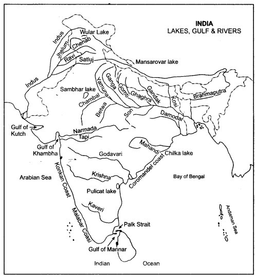
The Krishna: The Krishna is the second longest and largest east flowing river of peninsular India. It rises near Mahabaleshwar in Maharashtra, flows to a length of 140-0 km before joining the Bay of Bengal near Divi point. The koyna, Yerla, Panchaganga, Dudhganga, Bhima, Ghataprabha, malaprabha, Tungabhadra and the Musi are the main tributaries.
The Kaveri: The kaveri is a sacred river like the Ganga. It rises Talcauvery region in the Brahmagiri range of Coorg district in Karnataka state. If flows for a length of 805 kms before falling into the Bay of Bengal near Kaveripattinam. It drains an area of 87,900 sq.kms. Its main tributaries are Arkavathi, Hemavathi, Harangi, Lokapvani, Shimsa, Lakshmanathirtha, Kabini, Suvarnavathi, Bhavani, and Amaravathi.
B.2 West flowing rivers: These rivers rise in the peninsular region, flow in western direction and join the Arabian Sea. These are short and swift rivers are the luni, sabrmati, mahi, Narmada, Tapi, Mandovi, Zuari, kali, sharavvathi, Gangavati, Bedthi, Netravathi, and Periyar etc.
![]()