Students can Download 1st PUC Geography Model Question Paper 3 with Answers, Karnataka 1st PUC Geography Model Question Papers with Answers helps you to revise the complete Karnataka State Board Syllabus and score more marks in your examinations.
Karnataka 1st PUC Geography Model Question Paper 3 with Answers
Time: 3 Hrs
Max. Marks: 100
Note:
- Answer all questions.
- Draw maps and diagrams wherever necessary
- Questions No.V is on Cartography.
I. Answer the following in a word or a sentence each. ( 1 × 10 = 10 )
Question 1.
What is Lithosphere?
Answer:
The solid outer layer of the earth is known as Lithosphere.
Question 2.
Where is Gutenberg discontinuity?
Answer:
The boundary that separates the mantle from the core is known as ‘Gutenberg Discontinuity’.
Question 3.
What is the approximate age of the Earth?
Answer:
4.6 Billion years
Question 4.
What is an ‘Orbit’?
Answer:
The path on which the earth revolves around the Sun is called ‘Orbit’.
Question 5.
Why the inner core is called ‘solid core’?
Answer:
It is the lower layer of the Core consisting of hard molten rocks. Most of the materials are in molten form.
![]()
Question 6.
Where is Mohorovicic discontinuity?
Answer:
It is a boundary that separates the earth’s crust and the mantle.
Question 7.
Define Isohyets?
Answer:
These are the imaginary lines drawn to join the places with the same amount of rainfall.
Question 8.
What is the length of the land boundary of India?
Answer:
About 15,200 kilometers.
Question 9.
Which is called ‘Mawsynram of South India’?
Answer:
Agumbe of Karnataka is called ‘Mawsynram of South India.’
Question 10.
Define Ptomology.
Answer:
The Scientific study of Rivers.
II. Answer any ten of the following in two or three sentence each. ( 2 × 10 = 20 )
Question 11.
Why Geography is called ‘Earth Science’? (T. B. Qn)
Answer:
Geography is fundamentally a description of the earth. It deals with the varied natural or physical factors of environment, such as toad forms, mountains water bodies, minerals, climate, soils, natural vegetation and plains.
Question 12.
Why the Earth is called ‘Living Planet’?
Answer:
The Earth is the home for all forms of life like plants, animals and human beings because of its suitable distance from the Sun, range of temperature, life supporting gases, atmosphere water cycle etc. It is the only planet that supports life, that is why it is called ‘Living Planet’.
Question 13.
What is a Volcanic earthquake?
Answer:
These are associated with the activity of volcanoes and occur as a result of depth explosion of the gases and magma. Such volcanoes are confined to volcanic areas. The intensity of such earthquakes depends on the intensity of volcanic eruption. They are not very destructive e.g. Krakatau (1883) and Katmai (1912).
![]()
Question 14.
Mention the types of sedimentary rocks?
Answer:
Based on Origin and composition sedimentary rocks are divided into three types’
- mechanically formed rocks,
- Chemically formed rocks
- Organically formed rocks.
Question 15.
What is Mass movement?
Answer:
Mass movement includes a variety of gravity induced movements of slope material, but excludes transportation by running water, wind, and glacier. Transfer of one mass of rock debris down the slopes is the regular activity of mass movement. Rockfall, talus, Earth flows, landslides, are the major forms of mass movements.
Question 16.
What is Ionosphere?
Answer:
The thin layer extends from the ozonosphere form an altitude of about 80 to 640 km above the earth surface. The process of ionization takes place in this zone, resulting in a dense concentration of positive ions.
Question 17.
Why is ocean deep or trench important in the Ocean bottom?
Answer:
An arc-shaped depression in the deep ocean floor is called ocean deep or trench. These are the deepest parts of the ocean floor. Ocean trenches are produced by the subduction of oceanic crust under continental crust. They resemble step sided valleys or canyons on the land. Trenches or deeps are generally parallel of the coasts facing mountains and along the islands. Great earthquakes and tsunamis generally take birth in this region.
Question 18.
What is Echo sounding?
Answer:
It is a technique of using sound pulses to find the depth of water. Eco sounder is a device for measuring depth of water by sending pressure waves down from the surface and recording the time until the echo returns from the bottom.
Question 19.
What is the Aquatic bionic?
Answer:
Aquatic regions house numerous species of plants and animals, both large and small. This is where life began billions of years ago. Without water, most life forms would be unable to sustain themselves and the Earth would be a barren, desert-like place. Ponds, lakes, rivers, wetlands and oceans are sources of aquatic biomes.
![]()
Question 20.
Why has India selected a Standard Meridian of India with an odd value of 82° 30’ E?
Answer:
On the International basis the globe has been divided into 24 time zones (each of 15 longitudes).
In every zone local time of the middle longitude (divided by 7° 30’) is taken as standard time of the entire zone. Because 82 ’/2 ° E is well divisible by 7° 30’. A standard adopted by almost all the countries ofthe world while they selected a Standard meridian for their respective countries.
Question 21.
Write a short note on Retreating Monsoon?
Answer:
The season of Retreating Monsoon is the period of Transition. During the period of transition low pressure of the north-west shifts to the Bay of Bengal. It results in the formation of cyclones over the Bay. These cyclones cause havoc on the coasts of Orissa and Andhra Pradesh.
Question 22.
State two important flood prone areas of the country.
Answer:
The Ganga Basin: The badly affected states of the Ganga basin area Uttar Pradesh, Bihar and West Bengal.
The Brahmaputra basin: the Brahmaputra along with its tributaries floods the areas of Assam and North West Bengal regions.
III. Answer any eight of the following in 25 to 30 sentences each. ( 5 × 8 = 40 )
Question 23.
Explain the effects of the rotation of the Earth.
Answer:
Rotation of the Earth causes various effects. They are:
a. Day and night caused by the rotation of the earth on its axis. This is because parts of the earth which face the sun have day and the parts which do not face the sun have night. This happen with precision and progression and not suddenly – The time when the sun beings to cast its light in the sky is known as dawn. At noon. The sun is overhead. At dusk, it is twilight and the sun is seen disappearing in the sky. At night, it is completely dark.
b. The duration of the day and night is not equal at all places on the earth because of the inclined axis. The length of days varies with respect to the seasons as well as latitude
c. The sun, the moon and the stars seem to move from east to west. This is because the earth spins from west to east. This effect is similar to what one experiences while looking at trees from a moving train.
d. The speed of rotation has created a centrifugal force resulting in a bulge in the middle portion of the earth and flattened top at the poles.
e. The earth’s rotation affects the movement of water in the oceans. The tides are deflected because of the rotation of the earth.
f. Rotation causes difference in time over various places on the earth.
g. The Earth acts as huge magnet: The one end of the needle of the compass always points towards the north magnetic pole. That means, the earth acts as a magnet. The rotation . of the earth causes the earth to act as a magnet.
h. Rotation of the Earth influences the movement of ocean water, particularly ocean currents.
i. The rise and fall in the sea level is called tides. Rotation of the Earth causes the lacing of water bodies to the Moon. The gravitational attraction of the Moon and position of the water bodies cause tides. This is a regular phenomenon due to Earth’s rotation.
Question 24.
Explain the Earthquake waves?
Answer:
The earthquake waves based on their mode of traveling and velocity are broadly classified into three types. They are,
- Primary (P) waves
- Secondary (S)waves
- Surface (L) waves
1. Primary (P) waves: These are also known as Push waves or waves of compression. The particles vibrate in the direction of the movement of the wave, similar to a sound wave. They can travel through solid, liquid and gases. The velocity varies from 5.5 to 13 km per second depending on the medium of their travel they are the first to be recorded in the epicenter by the seismograph.
2. Secondary (S) waves: They are recorded on a seismogram after the P) waves. These are also called traverse or shake waves (S). These are distortional waves as the particles vibrate at right angles to the direction of the movement of the waves. The velocity of the secondary waves varies form 3 to 7 kms per second. They can travel through the interior and outer layer of the earth but cannot be transmitted by liquids.
3. Surface waves: These are also described as Long waves (L). The ‘L’ waves travel along the surface of the earth and are recorded after ‘P’ and ‘S’ waves. Their speed is 4 kms. The surface waves are most destructive as they vibrate much.
Question 25.
Explain the types of River Course.
Answer:
River is an important external agent of denudation on the ever-changing face of the Earth. The work of river is more or less common in all the drainage systems of the world.
The work of river consists of three closely interrelated activities.
1. Erosional work: The process of wearing and taking away the part of rock is known as ‘Erosion’. It depends upon the volume and velocity of water, nature of slope and the nature of rocks. The erosional work of the river is performed in two ways.
a. The Mechanical and b. The Chemical erosion.
There are various Iandforms associated to erosional work of river.
a. ’V’ Shaped valley: In the mountain course the speed of the river is greater and volume is less. As the water rushes down the steep slopes there is maximum vertical , or later erosion. The rapid down cutting or vertical erosion results in the formation of ‘V’shaped valley.
b. Gorge: A deep and narrow valley with steep rocky, sides in the river course is known as ‘Gorge’. They are formed by the regular vertical cutting by the rivers in the valleys eg. Narmada gorge.
c. I shape valley: Avey steep, deep river valley formed by the river, lookinglike T, is called ‘I’ Shaped valley. These are very deep compared to gorges.
d. Canyon: It is a wide, deep and steep valley almost with vertical walls like feature found in the arid or semi arid regions is called ‘Canyon’ eg. Grand Canyon of River Colorado in USA.
e. Potholes: These are the small depressions in the rocky beds of other river valley. They are formed by corrosion. Pebbles, sand and small rocks carried by the river swirled around on the river bed. This action erodes the rock on the river bed forming potholes.
f. Waterfalls: Huge volume of water falling from a great height along the course of a river is called “Waterfalls’. They are formed when the hard and soft rocks come in the way of flowing river. The soft rock gets eroded faster and hard rock does not erode easily. Therefore huge amount of water falls from great height and creates waterfalls. Eg. The Jog falls, The Angel falls, The Victoria falls.
g. River Capture: It is formed mainly due to head-ward erosion by the river near its source. When the source of a river is captured by another major and strong river it is called‘River Capture’.
2. Transportational work: The process of carrying away the eroded materials is known as ‘Transportation’. The rock materials and eroded particles carried by a river is called its Load. The transportation capacity of a river is based on velocity of water, volume of water, load, slope, smooth valley floor etc.
The major landforms associated with the transportational work of the river are:
a. Alluvial fans: The term alluvium refers to the debris transported and deposited by rivers. When the fast flowing river enters the plateau or plain region, it experience sudden decline in gradient and obstruction in its path. Due to obstruction of the river spreads and deposits many of its light materials in fan shape known as ‘alluvial fans’.
b. Alluvial cones: In the plateau and foot hill region when the river spreads out, the eroded materials carried by the river is deposited in conical shape called ‘Alluvial cones’.
3. Depositional work: The process of carrying and accumulating the eroded materials by the river at the lower course is called ‘deposition’. In the lower course due to gentle slope the river slows down and deposits most of its materials on the banks, course and the mouth.
The important landforms resulting from depositional work of the river are:
a. Meanders: In the lower course, river flows slowly in zig zag or curved manner due . to smaller obstruction in its path. A curve or loop formed by the river in its path is called ‘Meander’. When the river course formed by such crescent shaped loops due to continuous lateral deposition it is called meandering course.
b. Ox-bow Lakes: The ox-bow lakes are formed by depositional and erosional actions taking place simultaneously and they are a result of excessive meandering. The River which flows through the shorter route leaving the curve of the meander cut off and crescent shaped lake is formed known as‘Ox-bow lakes’.
c. Flood Plains: When the river is in floods the water overflows on its bank and spreads in the surrounding regions. The silt carried by the water gets deposited in these areas and creates flat plains on both the banks of the rive known as ‘Flood Plains’.
d. Delta: A triangular shaped alluvial deposition forced at the mouth of the river is called ‘Delta’. Important types of deltas are
a. Arcuate or Common delta
b. Bird-foot delta
e. Distributaries: As the river approaches the sea or Ocean, due to reduction in gradient, joining of tributaries, its volume increases, speed decreases hence, the rivet begins to break up into a number of branches from the main river called ‘Distributaries’.
f. Estuary: Estuaries are the tidal mouth of a river having a narrow, gradually widening lay at the mouth. In Estuary River water is mixed with seawater. Eg. The Narmada estuary, The Kali estuary.
Question 26.
What is solar radiation? Explain the factors controlling solar radiation.
Answer:
The solar radiation is in the form of shot waves. These waves strike the outer surface of the atmosphere. About 53% of the energy is lost through scattering by gas molecules, reflection by clouds and absorption by water vapor and other particles. Only about 47 percent of the energy reaches the surface.
Controlling factors: Insolation is not uniform on all parts of the earth’s surface. It differs from one region to another and also from one season to another. The important factors determining the amount of solar radiation are:
a. The angle of incidence of the sun’s rays: The sun rays do not strike the earth surface at an. equal angle. They are almost perpendicular as well as concentrated near the equator and slanting as well as spread over a large area at the poles.
b. Atmosphere: The amount of insolation also depends on the atmosphere through which it passes. The amount of cloud cover, its thickness, dust, water vapour absorbs temperature.
c. Duration of Day: The duration of sunshine or day varies with the seasons and latitudes. Longer the duration of sunshine, more will be the insulation and vise versa, d. Distance between the earth and the sun: The earth revolves around the sun on its orbit. It is nearest to the sun on January 3 and far away on July Thence the solar radiation is more in January than in the month of July.
![]()
Question 27.
What are the characteristics of Isobar?
Answer:
The distribution of pressure over the earth’s surface or part of it is shown by means of isobars.
The term isobar means line ofjoining the places of equal pressure.
Important characteristics of isobars are:
- If the isobars are far apart, it indicates gentle pressure gradient as well as calm weather characterized with light surface winds.
- The isobars usually follows east-west trend.
- The isobars deviate in their trend at the point of their entrance from sea to land as well as from land to sea.
- The isobars are almost parallel to latitudes in the southern hemisphere due to predominance of oceans.
- If the isobars are close to earth other it represents steep isobaric gradient. It also indicates more atmospheric disturbances as well as strong winds.
![]()
Question 28.
What are the cyclones? Explain the types of cyclones.
Answer:
Cyclone is a small low pressure area in the centre surrounded by high pressure. The winds blow spirally towards the low pressure area and form convergence of winds. In the northern hemisphere the direction of cyclonic winds is anti-clockwise and in the Southern hemisphere it is clockwise. The cyclones are classified into two types.
(i) Tropical Cyclones: The origin of tropical cyclones is much related to intensive They cause heavy rainfall with high-velocity winds. Tropical cyclones are highly dangerous and devastating.
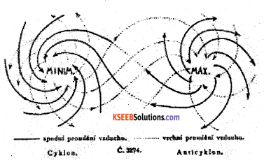
(ii) Temperate Cyclones: In the temperate region, cyclones are produced by the meeting of warm air mass of tropical region and cold air mass of the polar region. The tropical. air mass is lighter and it is pushed up by the advancing dense cold air mass. The process of mixing of these two air masses takes palace in the form of cyclones. They are ‘ associated with heavy rainfall.
![]()
Question 29.
Explain the factors affecting Rainfall.
Answer:
There are various factors affecting the rainfall. They are as follows:
Latitude: Rainfall is influenced by the latitude. If the latitude is low, temperature will be high. Water vapour in the air depends upon the temperature. Rainfall depends upon the amount of water vapour in the air. Evaporating is highest in the equator and least at the poles. Therefore rainfall is more in the equator and less or nil at the poles.
Distance from the sea: Winds blowing from the sea bring rainfall over the coastal lands. But as these winds go further, they become drier. Therefore they do not bring much rainfall in the continents.
Mountains: There is heavy rainfall in the windward side of the mountains because the mountains obstruct the winds carrying moisture. But there is little rainfall on the leeward side of the mountains. This is because, by the time the winds cross the mountains, they lose much of their moisture and become dry.
Type and direction of winds: Winds blowing from the sea contain moisture, and therefore bring rain to the land over which they blow. But winds blowing from the land is dry, and therefore, they do not cause rains. Similarly winds blowing from the cold regions to hot regions cause little rainfall, while the winds blowing from hot regions to cold regions cause more rainfall.
Vegetation: Rainfall is more in a region where there is thick vegetation, i.e., forests, because the forests make the air cool. That is why, Assam and mainland areas get more rainfall than the desert and the malnad areas.
![]()
Question 30.
Explain the topography of the Ocean floor with a diagram. (T. B. Qn )
Answer:
On the basis of the depth, the ocean floor can be divided into four zones, parts or relief features. They are.
1. The continental Shelf: The gently sloping portion of the continent or land that lies submerged below other sea is called the continental shelf. The continental shelf has a very gentle slope. It extends form the shore line to depths between 180 and 200 meters. Average width of the continental shelves is about 48km. The extent of the continental shelf depends on the relief of the broadening land masses.
If the coastal area is a plateau area, the continental shelf will be very broad. On the other hand, if the coastal region is hilly or mountainous, the continental shelf will be very narrow or even absent for example the Atlantic Ocean has 2.3%, the Pacific Ocean has 5.7% and the India Ocean has 4.2%.
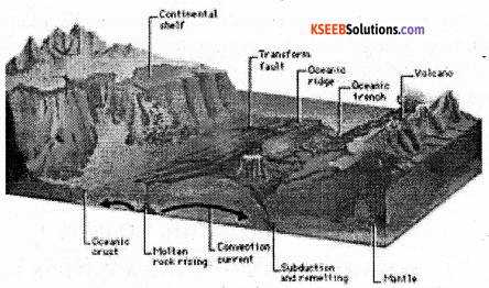
2. The continental slope: The zone of steep slope that descends from the edge of the continental shelf to the deep sea plains is called “continental slope”. It is the transitional zone lying between the continental shelf and the deep sea plains. The continental slope is very steep. It extends from 182 meters to 3.600 meters. The angle of the continental slope is 2 to 5 degre3es or even more. It occupies only 8.5% of the total area of the ocean floor. But it varies from ocean to ocean. The Atlantic Ocean has broader continental slopes and accounts for 12.4%. But it is 7% of the Pacific Ocean and 6.5% of the Indian Ocean.
3. The deep sea plains: The level and rolling areas of the ocean floor are generally called deep sea plains or abyssal plains or the ocean plains. They lie between 3,000 and 6,000 meters below other surface of the ocean. They occupy vast area of the ocean floor and account for about 82.7% of the total sea floor. They cover about 90% in the Indian Ocean. Their depth ranges from 5,000 to 6,000 meters. They are covered by oozes, which are the remains of deep sea creatures and plants, and of red volcanic dust.
4. The Ocean Deeps: The long narrow and deep troughs on the ocean floor are known as ‘ocean deep’ or ‘trough’. They cover only 1% of the ocean floor. They are most common neat the coasts where young fold mountains, volcanoes and earthquakes abound. Some they are tectonic in origin. They are the deepest portions of the ocean. Deeps may be caused due to tectonic forces, i.e. faulting earthquakes etc. There are 57known deeps. Of these 32 are found in Pacific Ocean, 19in the Atlantic Ocean and 6 in the Indian Ocean. The deepest trench in the world is Challenger deep located in Mariana Trench to the west of Philippines in the North Pacific Ocean.
Question 31.
Explain the major seismic zones of India.
Answer:
Zone V: This is the most severe seismic (intensity above 7 in Richter scale) seismic zone and is referred as Very High Damage risk zone. The areas are. Northeastern states, parts of Jammu Kashmir, Uttarkhand, and Bihar and Kutch region.
Zone IV: This zone is second in severity (intensity between 5 and 7 in R.S) to zone VG. This is referred to as High Damage Risk zone. Northern regions of Jammu and Kashmir, Himachal Pradesh, Parts of Bihar, UP, Gujarat, West Bengal lie in this region zone. Northern regions of Jammu and Kashmir, Himachal Pradesh, parts of Bihar, UP, Gujarat, West Bengal.
Zone III: This is termed as Moderate Damage (very strong) Risk zone (intensity between 3 and 5 in R.S). The areas are Gujarat, Madya Pradesh, Rajasthan, Chhattisgarh, Odisha, Maharashtra, Northern Karnataka, Andhra Pradesh, West coastal region etc.
Zone II: This zone is referred to as low Damage (strong) Risk Zone (intensity 2 to 3 R.S). The areas are Rajasthan, Madhya Pradesh, Parts of Karnataka, Andhra Pradesh, Odisha etc.
Zone I: This zone is termed as Very Low Damage (Slight-tremor) Risk Zone. The left out parts of India and Deccan Plateau region.
Question 32.
Peninsular Plateau is the largest physical divisions of India. Explain its features.
Answer:
The Peninsular Plateau is the largest and oldest physiographic division of India. It lies to the south of the Northern Great Plains and covers and area of about 161akh sq km. The elevation of this upland varies from 600 to 90m. This is in inverted triangle shape, with wide base lying in the north and the apex formed in the south, with tilt towards south eat.
It is bounded by the Aravallis in the North West, Bundelkhand plateau in the north, Rajmahal hills in the north east, the Western Ghats in the west and the Eastern Ghats in the east. The highest peak of Peninsular plateau is Anaimudi (2695 m) situated in Annamali hills of Kerala.
On the basis of relief features the peninsular plateau is divided into two main divisions. They are, The Central high lands: This is a smaller region of peninsular plateau situated to the north of the Narmada river. It is slightly tilted towards north. It include the Aravallies, the Malwa plateau, the Vindhya range, the Bundelkhand, the Baghelkhand and Chotanagpur plateau and Rajmahal hills.
The Aravallies runs from north east to south west for about 8900 km between Delhi to Gujarat. It is one of the oldest folded mountains of the world. Its highest peak is Guru Shikar (1722m). It separates Rajasthan- upland and agricultural region. The Aravallis are composed of quatizetes, gneisses and schists.
Rivers like the Luni, Sabarmati and the mahi flow from Aravalli ranges. The Malwa plateau is bordered by the Aravallis in the north and the vindyan range in the south. This plateau has to drainage systems i) Narmada and Mahi towards the Arabian Sea ii) Chambal, Sind, Betwa and Ken towards the Bay of Bengal. ’
The vindyan range extends in ease west direction for about 1050km. The kaimur hills lies in the east of Vindhya range and the Maikala range forms a link between the Vindhya and Satpura ranges.
The Deccan Plateau: this is a triangular plateau situated to the south of the river Tapi or Tapti. The Deccan trap is the crystalline core of the lava effusions forming this plateau are believed to have occurred through a fissure volcano and this region is considered a lava shield. It occupies the areas of Maharashtra, Karnataka, Andhra Pradesh and parts of Chhattisgarh, Odisha and Tamil Nadu.
Eastern Ghats: They form eastern boundary of the Deccan Plateau. They are “separated by the river valleys. The Eastern Ghats stretch to 800 km from Mahanadi valley in the north to Nilgiri hills in the south. Its average height is around 600m.Nallamalla, Kallamalai, B.R.Hills and M.M.Hilis are the important hills of Eastern Ghats.
The important peaks are Aramakonda, Singaraju, Nimalgiri, Mahendra giri etc. Aramakonda is considered as the highest peak of the Eastern Ghats. These zones are rich in Iron ore, Manganese ore, Limestone, Coal, Mica etc.
Western Ghats: It is also known as Sahyadris. They are almost continuous mountain system running parallel to west coast for about 1600km., from north-west to south direction. The Western Ghats meet the Eastern Ghats in Nilgiri hills.
The Western Ghats form a watershed of the peninsular rivers. Important rivers like the Godavari, Krishna, Kaveri, Sharavati, Periyar etc, rise in this zone. They are sources of hydro¬electricity. They are covered with dense evergreen and monsoon forest and rich bio-diversity zones.
![]()
Question 33.
Describe the major types of forest in India.
Answer:
The peninsular region of India has the largest forest cover with around 57% of the total forest area.
According to geo-climatic conditions, forests are classified into:
a. Evergreen Forests: These forests are found in the regions of heavy rainfall and high temperature. Tall umbrella shaped trees with dense assemblage is a prominent feature of this forest. The eve4rgree forest always looks green because various species of trees are found here and they shed leaves in different seasons.
The hardwood trees, rose wood, white cedar, toon, gurjan, chaplash, ebony, Mahogany, canes, bamboo, shisham etc. These are found in North-east India, Western Ghats, Andaman and Nicobar islands, parts of Assam and some areas of Himalayan foot hills.
b. The Deciduous forests: The deciduous forest covers a wide range of rainfall regimes. The trees of these forests seasonally shed their leaves. The Indian deciduous forest is found in a range of landscapes from the plains to the hills. These forests provide shelter to most endangered wild life in the country, such as the Tiger, Asian Elephant, Bison, Gaur etc. The deciduous forest are two types
(i) Moist Deciduous forests: The moist deciduous forests are found in wet regions, receiving annual rainfall between 100cm to 200cam and temperature of 25° C to 30° C. The trees of these forests shed their leaves during spring and early summer. They are found on the eastern slopes of the Western Ghats, Chota Nagpur Plateau, the siwaliksetc.
(ii) The Dry Deciduous Forests: The dry deciduous forest are found I the areas where annual rainfall is between 50cm to 150 cm and temperature of 25° C to 30° C. Sal is the most significant tree found in this forest. Varieties of acacia and bamboo are also fund here. These forests are found in areas of central Deccan plateau, South-east of Rajasthan, Punjab, Haryana and parts of Uttar Pradesh and Madhya Pradesh.
(iii) The mountain forests: As the name indicates these forests are confined to the Himalayan region, where the temperature is less compared to other parts of the country. The trees in this forest are cone shape with needle like leaves. The important trees are oak, fir, pin e spruce, silver fir, deodhar, devdar, juniper, picea chestnut etc. They provide softwood for making country boats, packing materials and sport articles.
c. The Desert forests: These forests are found in the areas of very low rainfall. Thorny bushes, shrubs, dry grass, acacia, cacti and babul are the important vegetation found in these forests. The Indian wild date known as ‘Khejurs”, is common in the deserts. They have spine leaves, long roots and thick fleshy stems in which they store water to survive during the long drought. These vegetations are found in Rajasthan, Gujarat, Punjab and Haryana.
d. The Mangrove Forests: These forests occur along the river deltas (Ganga, Mahanadi. Godavari and Krishna) of eastern coast and also concentrated in the coastal areas of Katchch, Kathiawar, and Gulf of Khambar. The mangrove forests in the Ganga delta are called Sunder bans because, they have extensive growth of Sundari trees. The trees in these forests are hard, durable and are used in boat making and as fuel. In the recent years mangrove vegetation is being grown I the coastal areas to control effects of tidal waves and coastal erosion.
![]()
Question 34.
What are Biosphere reserves? Mention the important biosphere reserves of India.
Answer:
A biosphere Reserve is a unique and representative ecosystem of terrestrial and coastal areas .The regions surrounding the biosphere reserves would be utilized for the research and experimentation in developing forest and other products.
The Man and the Biosphere Programme (MAB) of UNESCO was established in 1971 to promote interdisciplinary approaches to management, research and education in ecosystem conservation and sustainable use of natural resources. Eight of the eighteen biosphere reserves are a part of the world network of Biosphere reserves, based on the UNESCO man and the Biosphere Programme list.
The objectives of Biosphere reserves:
- Conservation of biodiversity and ecosystem.
- Association of environment with development.
- International network for research and monitoring.
| Sl.No | Name of the Biosphere reserve | State | Estd.Year |
| 1. | Nilgiri Biosphere Reserve | Tamilnadu, Kerala, Karnataka | 2000 |
| 2. | Gulf of Mannar Biosphere Reserve | Tamil Nadu | 2001 |
| 3. | Sunder bans Biosphere Reserve | West Bengal | 2001 |
| 4. | Nanda Devi Biosphere Reserve | Uttarkhand | 2004 |
| 5. | Nokrek Biosphere Reserve | Meghalaya | 2009 |
| 6. | Panchmarhi Biosphere Reserve | Madhya Pradesh | 2009 |
| 7. | Simlipal Biosphere reserve | Odisha | 2008 |
| 8. | Achanakmar-Amarkantak | Chhattisgarh, Jharkhand | 2012 |
![]()
IV. Answer any one of the following. ( 10 × 1 = 10 )
Question 35.
Describe the landforms associated to work of river.
Answer:
River is an important external agent of denudation on the ever-changing face of the Earth. The work of river is more or less common in all the drainage systems of the world.
The work of river consists of three closely interrelated activities.
1. Erosional work: The process of wearing and taking away the part of rock is known as ‘Erosion’. It depends upon the volume and velocity of water, nature of slope and the nature of rocks. The erosional work of the river is performed in two ways.
a. The Mechanical and b. The Chemical erosion.
There are various Iandforms associated to erosional work of river.
a. ’V’ Shaped valley: In the mountain course the speed of the river is greater and volume is less. As the water rushes down the steep slopes there is maximum vertical , or later erosion. The rapid down cutting or vertical erosion results in the formation of ‘V’ shaped valley.
b. Gorge: A deep and narrow valley with steep rocky, sides in the river course is known as ‘Gorge’. They are formed by the regular vertical cutting by the rivers in the valleys eg. Narmada gorge.
c. I shape valley: Avey steep, deep river valley formed by the river, lookinglike T, is called ‘I’ Shaped valley. These are very deep compared to gorges.
d. Canyon: It is a wide, deep and steep valley almost with vertical walls like feature found in the arid or semi arid regions is called ‘Canyon’ eg. Grand Canyon of River Colorado in USA.
e. Potholes: These are the small depressions in the rocky beds of other river valley. They are formed by corrosion. Pebbles, sand and small rocks carried by the river swirled around on the river bed. This action erodes the rock on the river bed forming potholes.
f. Waterfalls: Huge volume of water falling from a great height along the course of a river is called “Waterfalls’. They are formed when the hard and soft rocks come in the way of flowing river. The soft rock gets eroded faster and hard rock does not erode easily. Therefore huge amount of water falls from great height and creates waterfalls. Eg. The Jog falls, The Angel falls, The Victoria falls.
g. River Capture: It is formed mainly due to head-ward erosion by the river near its source. When the source of a river is captured by another major and strong river it is called‘River Capture’.
2. Transportational work: The process of carrying away the eroded materials is known as ‘Transportation’. The rock materials and eroded particles carried by a river is called its Load. The transportation capacity of a river is based on velocity of water, volume of water, load, slope, smooth valley floor etc.
The major landforms associated with the transportational work of the river are:
a. Alluvial fans: The term alluvium refers to the debris transported and deposited by rivers. When the fast flowing river enters the plateau or plain region, it experience sudden decline in gradient and obstruction in its path. Due to obstruction of the river spreads and deposits many of its light materials in fan shape known as ‘alluvial fans’.
b. Alluvial cones: In the plateau and foot hill region when the river spreads out, the eroded materials carried by the river is deposited in conical shape called ‘Alluvial cones’.
3. Depositional work: The process of carrying and accumulating the eroded materials by the river at the lower course is called ‘deposition’. In the lower course due to gentle slope the river slows down and deposits most of its materials on the banks, course and the mouth.
The important landforms resulting from depositional work of the river are:
a. Meanders: In the lower course, river flows slowly in zig zag or curved manner due . to smaller obstruction in its path. A curve or loop formed by the river in its path is called ‘Meander’. When the river course formed by such crescent shaped loops due to continuous lateral deposition it is called meandering course.
b. Ox-bow Lakes: The ox-bow lakes are formed by depositional and erosional actions taking place simultaneously and they are a result of excessive meandering. The River which flows through the shorter route leaving the curve of the meander cut off and crescent shaped lake is formed known as‘Ox-bow lakes’.
c. Flood Plains: When the river is in floods the water overflows on its bank and spreads in the surrounding regions. The silt carried by the water gets deposited in these areas and creates flat plains on both the banks of the rive known as ‘Flood Plains’.
d. Delta: A triangular shaped alluvial deposition forced at the mouth of the river is called ‘Delta’. Important types of deltas are
a. Arcuate or Common delta
b. Bird-foot delta
e. Distributaries: As the river approaches the sea or Ocean, due to reduction in gradient, joining of tributaries, its volume increases, speed decreases hence, the rivet begins to break up into a number of branches from the main river called ‘Distributaries’.
f. Estuary: Estuaries are the tidal mouth of a river having a narrow, gradually widening lay at the mouth. In Estuary River water is mixed with seawater. Eg. The Narmada estuary, The Kali estuary.
![]()
Question 36.
What is Bio-diversity? Explain the types and conservation of Bio-diversity.
Answer:
Bio-diversity means the diversity of variety of world’s living organism. In other words, the variety of species both flora and fauna present in an area is known as “bio-diversity”. According to the world resource institute: bio-diversity is a variety of the world’s organism’s including their genetic diversity and the assemblage they form.
The earth is endowed with a rich variety of living organisms. About 3,50,000 species of plants and 30, 00,000 species of animals have been identified so fat. India is one of the twelve countries of the world very rich in bio-diversity. India has about 46,000piant species and 81,000 animal species.
Types of Bio-diversity: Bio-diversity can be classified into there types. They are :
Genetic diversity, Species diversity and Eco-system diversity.
a. Genetic diversity: Genetic diversity refers to the variety of genes present in the members of species. This is basic level.
b. Species diversity: Species diversity refers to the variety of species in a specific place or among a specific group of organisms. This is the most familiar type and is found in the tropical zone that in cooler areas. India is rich in bio-diversity. This is due to its tropical location, varied relief features and climate.
c. Eco-system diversity: Eco-system diversity refers to the variety of geographical situations on the earth such as lakes, forests, deserts etc, and the number of plants and animals found in each. Each type of ecosystem has a variety of species that differ from each other.
Conservation of bio-diversity: As loss of biodiversity is not desirable, there should be conservation of biodiversity. Effort should be made to maintain biodiversity.
The following steps may be taken for preserving biodiversity:
- The biological diversity should be identified and monitored.
- There should be the development of national strategies and programs for conserving biological diversity.
- National parks and sanctuaries must be developed for the protection and maintenance of plants and animals.
- Botanical gardens should be developed for the developed for the development and maintenance of new species of flower and other plants.
- Zoos should be developed for the protection and development of rare and new animal species.
![]()
V (A) Answer the following in a sentence each. ( 1 × 5 = 5 )
Question 37.
What is latitude?
Answer:
These are the imaginary angular lines drawn parallel to the equator.
Question 38.
Define Index.
Answer:
A map is defined as a symbolical and conventional representation of the earth or a portion fit drawn to scale on a flat surface and bounded by the geographical coordinates as viewed from above.
Question 39.
What is Weather Map?
Answer:
They show the weather conditions at fixed time. Average atmospheric pressure, wind velocity and direction, cloudiness, rainfall, drizzle; know fall, sea conditions and other weather phenomena are shown on these maps. These maps are published daily by the meteorological department.
i.e. Indian Daily Weather Report.
Question 40.
What is full form of GIS?
Answer:
Geographical Information System.
Question 41.
Give an example for Large scale map.
Answer:
The distribution maps, where the dot method is applied to show the distribution of economic phenomena e.g. population, agricultural crops, industries etc. Dots of uniform size are used where each dot represents a certain number or quantity.
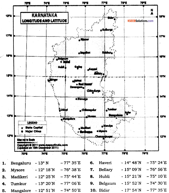
(B) Identify the latitudes and longitudes for the given places. ( 1 × 5 = 5 )
Question 42.
Bellary
Question 43.
Hubli
Question 44.
Madikeri
Question 45.
Shimoga
Question 46.
Hassan
Answers:
(C) Draw diagrams to the following. ( 2 × 2 = 4 )
Question 47.
Layers of earth interior.
Answer:
Earth’s Interior :
The Earth is divided into three main layers. The dense, hot inner core (yellow), the molten outer core (orange), the mantle (red), and the thin crust (brown), which supports all life in the known universe.
Question 48.
Temperate zones.
Answer:
The Temperate zone: In between the Torrid and the frigid zones i.e., between 23Y20N and South and 66V20N and S lies the Temperate Zone. ¡n this zone the sun’s rays fall obliquely and hence the region experiences a moderate climate.
(D) Draw the outline map of India, mark and name the following
Question 49.
Map drawing. (2)
Question 50.
Perennial River system of India. (2)
Question 51. (2)
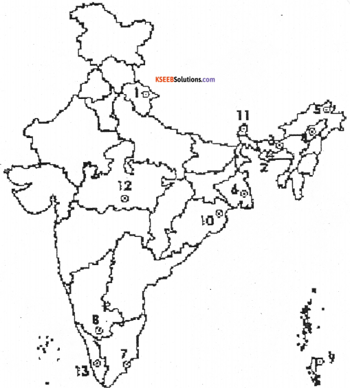
Manas and Cold desert biosphere reserves.
Answers:
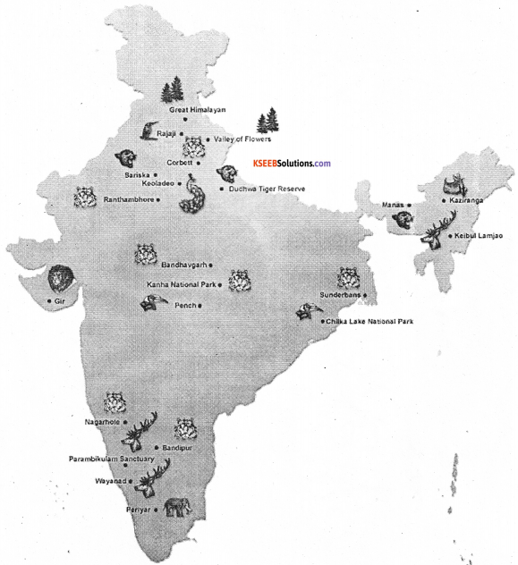
National park and Wild life in India
![]()
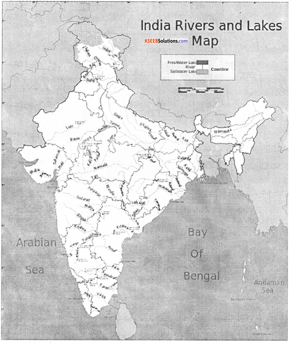
Rivers and Lakes
![]()
Biosphere Reserves
- Nanda Devi Saikhawa
- Nokrek
- Manas
- Dibru
- Dehang Debang
- Sunderbans
- Gulf of Mannar
- Nilgiri
- Great Nicobar
- Similipal
- Khanghendzonga
- Panchamarhi
- Agasthymalai
- Achanakmari – Amar Kantak